
Crévéchamps
| Crévéchamps | ||
|---|---|---|

|
|
|
| region | Grand Est | |
| Department | Meurthe-et-Moselle | |
| Arrondissement | Nancy | |
| Canton | My au Saintois | |
| Community association | Meurthe Mortagne Moselle | |
| Coordinates | 48 ° 31 ' N , 6 ° 16' E | |
| height | 235-337 m | |
| surface | 4.86 km 2 | |
| Residents | 393 (January 1, 2017) | |
| Population density | 81 inhabitants / km 2 | |
| Post Code | 54290 | |
| INSEE code | 54144 | |
 Town center in the 1920s |
||

Crévéchamps (1793 still with the spelling Crévéchamp ) is a French commune with 393 inhabitants (as of January 1, 2017) in the Meurthe-et-Moselle department in the Grand Est region ( Lorraine until 2015 ). The municipality belongs to the Arrondissement of Nancy and the municipality of Meurthe Mortagne Moselle .
geography
The municipality is located at the intersection of several roads on the left bank of the Moselle , around 25 kilometers southeast of Nancy and 22 kilometers southwest of Lunéville . Left, parallel to the Moselle, runs the Canal des Vosges , which crosses the Orvillers tributary in Crévéchamps .
Neighboring municipalities to Crévéchamps (clockwise, starting from the north) are: Tonnoy , Velle-sur-Moselle , Haussonville , Saint-Mard , Saint-Remimont and Benney .
Toponymy and History
Up until the 16th century there was a village called Urville (Orvillare) near where the village is today . The village of Crévéchamps was founded in late antiquity by the Gallo-Romans as Crépatus Campus , which could be derived from the Latin crepa = goat .
The field name La Garenne in the south of the municipality was a hunting area, named after the hermitage La Garenne on the southern edge of the municipality (today a farm). The two brothers hermits sheltered there a votive picture with the Titles of Mary Our Lady of Grace . Immediately pilgrims arrived in the hermitage. The statue was brought to the village church, consecrated in 1774, which is still the destination of pilgrims on July 2nd of each year.
The emblem of the Marquis von Neuviller , to whose rule Crévéchamps belonged, is immortalized with the burning mountain in the municipality's coat of arms . The crook symbolizes the former dependence on the Abbey in Flavigny .
Residents
| 1962 | 1968 | 1975 | 1982 | 1990 | 1999 | 2006 | 2017 | ||
|---|---|---|---|---|---|---|---|---|---|
| 238 | 247 | 271 | 262 | 298 | 304 | 320 | 393 | ||
| Sources: Cassini and INSEE | |||||||||
Attractions
- Church of the Assumption ( Église de l'Assomption )
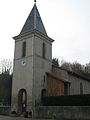
Tower of the Church of the Assumption

Statue of Our Lady of Grace in the Church of the Assumption

Mairie Crévéchamps


_mairie.jpg)
Economy and Infrastructure
There are four farms in the municipality of Crévéchamps (including horse breeding).
The D 570 from Ludres to Charmes runs through the municipality of Crévéchamps . A few kilometers to the west, the motorway-like RN 57 runs from Nancy to Épinal . In Rosières-aux-Salines , eleven kilometers away, there is a connection to the A 33 autoroute . Damelevières train station, eleven kilometers to the east, is on the Paris – Strasbourg line .
supporting documents
- ↑ toponym on cassini.ehess.fr
- ↑ Crévéchamps on cassini.ehess.fr
- ↑ Crévéchamps on insee.fr
- ↑ Farms on annuaire-mairie.fr (French)