Tomblaine
| Tomblaine | ||
|---|---|---|

|
|
|
| region | Grand Est | |
| Department | Meurthe-et-Moselle | |
| Arrondissement | Nancy | |
| Canton | Saint-Max | |
| Community association | Grand Nancy | |
| Coordinates | 48 ° 41 ′ N , 6 ° 13 ′ E | |
| height | 193-241 m | |
| surface | 5.55 km 2 | |
| Residents | 8,887 (January 1, 2017) | |
| Population density | 1,601 inhabitants / km 2 | |
| Post Code | 54510 | |
| INSEE code | 54526 | |
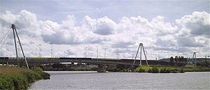
 Bridge over the Meurthe between Tomblaine and Nancy |
||
Tomblaine is a French commune with 8,887 inhabitants (as of January 1, 2017) in the Meurthe-et-Moselle department in the Grand Est region (until 2015 Lorraine ). It belongs to the Arrondissement of Nancy and the Canton of Saint-Max .
geography
Tomblaine is separated from Nancy by the Meurthe .
history
Origin of the name Tomblaine
There are several theories about the origin of the name Tomblaine :
- The Romans are said to have defeated the Alans at this point , hence the Roman name Tumulus Alanorum ( grave of the Alans ), French Tombeau des Alains , from which Tomblaine finally arose.
- The name is said to have developed from the Gallic words Tom (dam, mud) and Blaen or Blen (high place), i.e. a high place on a swamp.
Population development
| year | 1962 | 1968 | 1975 | 1982 | 1990 | 1999 | 2007 | 2017 |
| Residents | 5247 | 6617 | 8285 | 7828 | 7956 | 7853 | 7656 | 8887 |
partnership
The municipality of Tomblaine has maintained a partnership with the German municipality of Hasbergen since 1987 .
Personalities
- Dany Snobeck (* 1946), racing car driver
Web links
Commons : Tomblaine - collection of images, videos and audio files
