
Maidieres
| Maidieres | ||
|---|---|---|

|
|
|
| region | Grand Est | |
| Department | Meurthe-et-Moselle | |
| Arrondissement | Nancy | |
| Canton | Pont-à-Mousson | |
| Community association | Bassin de Pont-à-Mousson | |
| Coordinates | 48 ° 54 ' N , 6 ° 2' E | |
| height | 182-305 m | |
| surface | 1.81 km 2 | |
| Residents | 1,547 (January 1, 2017) | |
| Population density | 855 inhabitants / km 2 | |
| Post Code | 54700 | |
| INSEE code | 54332 | |
 Maidières Castle and Town Hall ( Mairie ) |
||

Maidières is a French commune with 1,547 inhabitants (as of January 1, 2017) in the Meurthe-et-Moselle department in the Grand Est region (until 2015 Lorraine ). It belongs to the Arrondissement of Nancy and the Canton of Pont-à-Mousson (until 2015: Canton Dieulouard ).
geography
Maidières is about 25 kilometers north-northwest of Nancy . Maidières is surrounded by the neighboring communities of Montauville in the north and west, Pont-à-Mousson in the north and east and Blénod-lès-Pont-à-Mousson in the south.
The former route nationale 58 (today's D958) limits the municipality to the north. The municipality is located in the Lorraine Regional Nature Park .
Population development
| year | 1962 | 1968 | 1975 | 1982 | 1990 | 1999 | 2006 | 2017 |
| Residents | 1143 | 1564 | 1571 | 1447 | 1353 | 1366 | 1521 | 1547 |
Attractions
- Saint-Nicolas church, Romanesque tower, otherwise from the 19th century
- Prochebois Castle from the 18th century
- Casanova Castle, built in the early 18th century
- Notre-Dame-des-Anges chapel ( Casanova ) from the 16th century

Saint-Nicolas church
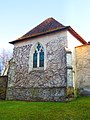
Casanova chapel


Web links
Commons : Maidières - Collection of images, videos and audio files