
Lazy
| Lazy | ||
|---|---|---|

|
|
|
| region | Grand Est | |
| Department | Meurthe-et-Moselle | |
| Arrondissement | Nancy | |
| Canton | Entre Seille et Meurthe | |
| Community association | Bassin de Pompey | |
| Coordinates | 48 ° 48 ' N , 6 ° 12' E | |
| height | 215-412 m | |
| surface | 17.2 km 2 | |
| Residents | 1,344 (January 1, 2017) | |
| Population density | 78 inhabitants / km 2 | |
| Post Code | 54760 | |
| INSEE code | 54188 | |

Faulx is a French commune with 1,344 inhabitants (as of January 1, 2017) in the Meurthe-et-Moselle department in the Grand Est region (until 2015 Lorraine ). The municipality belongs to the arrondissement of Nancy and the canton Entre Seille et Meurthe (until 2015: canton Nomeny ).
location
Faulx is about eleven kilometers north-northeast of Nancy . Faulx is surrounded by the neighboring communities of Belleau in the north and north-west, Sivry in the north, Bratte in the north and north-east, Montenoy in the east, Bouxières-aux-Chênes in the south-east, Eulmont in the south and south-east, Lay-Saint-Christophe in the south, Bouxières- aux-Dames in the southwest, Malleloy in the west and Custines in the west and northwest.
history
936 the place was called as Vadus sancti Petri .
Population development
| year | 1962 | 1968 | 1975 | 1982 | 1990 | 1999 | 2006 | 2017 |
| Residents | 810 | 859 | 1002 | 1064 | 1135 | 1170 | 1269 | 1344 |
| Sources: Cassini and INSEE | ||||||||
Worth seeing
- Saint-Pierre church from the 18th century
- Chapel of the former castle
- Old rectory from the 18th century
- Castle from 1730 (reconstruction of the castle from 1551)
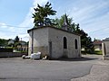
Chapel of the former castle

Saint-Pierre church

medieval tower


Personalities
- Louis Marin (1871–1960), politician