Saizerais
| Saizerais | ||
|---|---|---|

|
|
|
| region | Grand Est | |
| Department | Meurthe-et-Moselle | |
| Arrondissement | Nancy | |
| Canton | Le North Toulois | |
| Community association | Bassin de Pompey | |
| Coordinates | 48 ° 47 ' N , 6 ° 3' E | |
| height | 203-301 m | |
| surface | 14.44 km 2 | |
| Residents | 1,503 (January 1, 2017) | |
| Population density | 104 inhabitants / km 2 | |
| Post Code | 54380 | |
| INSEE code | 54490 | |
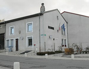
 Mairie Saizerais |
||
Saizerais is a French commune in the Meurthe-et-Moselle in the region Grand Est . It belongs to the Arrondissement of Nancy and the Bassin de Pompey municipal association, founded in 1995 .
geography
Saizerais, with 1503 inhabitants (as of January 1, 2017), is located roughly halfway between the cities of Nancy , Toul and Pont-à-Mousson . The landscape around Saizerais is poorly structured. It is part of a plateau, which in the south and east to the Moselle valley , in the north to Eschtal and southwest to Terrouintal drops. From a wider perspective, the plateau belongs to the Côtes de Moselle ridge that runs parallel to the left of the Moselle . Forests spread out around the municipality, which is almost entirely part of the Lorraine Regional Nature Park ( Forêt entre 2 Chemins, Forêt de l'Avantgarde, Forêt de Chenot-Hazotte, Forêt de Natrou ). The forests used to be part of the much larger forest area Forêt de Haye , the core of which today surrounds the city of Nancy in a semicircle.
The settlement itself consists of two parts, still recognizable today, which were independent until the 18th century: the smaller Saint-Georges in the north and Saint-Amand in the south. The dead straight road from Rosières-en-Haye to Marbache on the Moselle runs between the two parts. Along this street, a third settlement axis has formed next to the two old village centers. A housing estate was built in the east in the 1970s. The church was deliberately built between Saint-Georges and Saint-Amand in the 19th century to unite the villages. The distinction between le gros Saizerais and le petit Saizerais is still present among the residents today.
Saizerais also includes a street ( avenue le Gloan ) in Toulaire , a former military settlement , now part of the municipality of Liverdun . The settlement was built in 1957 by the Americans for the servants of the nearby air base in Toul ( Base aérienne 136 Toul-Rosières ). After the US Army withdrew, the houses were sold to private individuals in 1970. The houses standing close together in the forest without front gardens and with large windows look exotic today.
Neighboring municipalities of Saizerais are Dieulouard in the north, Belleville in the northeast, Marbache in the east, Liverdun in the south, Rosières-en-Haye in the west and Villers-en-Haye in the northwest.
history
Located on the Roman road from Lyon to Trier , the name Saizerais probably goes back to the numerous villas with arches from the time of Caesar ( Caesaris arces ).
Written sources for the two originally separate places Saint-Georges and Saint-Amand can be found from the years 923 (name of the church ecclesia sancti Amandi Sasiriaca ) and 965 (certificate from Emperor Otto confirming the foundation of the abbey in Bouxières-aux-Dames ). In 1188, the term two Saizerais ( utroque Sasireis ) appeared for the first time in a document from the Bishop of Toul, Pierre de Brixey .
In 1305 Simon de Valmeis sold his possessions in Saizerais to the Count of Bar Edward I. One of Edward's successors, Duke Robert I , became lord of the area around the Avant-Garde fortress , to which Saizerais also belonged. The Avant-Garde castle, located high above the banks of the Moselle near Pompey , existed until 1636, when King Ludwig XIII. let them drag.
In the 17th century, lands around a hamlet that existed until around 1850 south of Saizerais belonged to Louis de Guise , the Baron of Ancerville and future Prince of Pfalzburg . In archives one found references to the viticulture in the middle of the 17th century, which today, however, is concentrated on the slopes in the Moselle valley.
Saizerais was not spared from disasters. Harvest failures in 1628 and 1629 were followed by two years of plague. Between 1632 and 1635 French and Swedish troops plundered and pillaged the country, which resulted in extensive depopulation. Parts of the village were uninhabited for ten years and fell into disrepair. After the Peace of Westphalia , the area around Saizerais recovered only slowly.
After the Peace of Rijswijk in 1697 a period of relative prosperity began. At the beginning of the 18th century, the twin community Saizerais was formed. It consisted of 28 households in Saint-Amand and 22 households in Saint-Georges . The mayors came alternately from one of the two suburbs.
Saizerais remained ecclesiastically divided. While the tithe from Saint-Amand was paid to the Chapter Liverdun , the tithe from Saint-Georges went to the canons of Bouxières .
History of the military base
The Toul-Rosières air force base is located immediately west of Saizerais (municipality of Rosières-en-Haye ). The history of military aviation began there during the First World War with the construction of a small airfield called Les brûlés . A squadron of two-seater reconnaissance aircraft was stationed here. Shortly before the start of World War II, the British built a new 900 meter runway and some barracks. The construction activity was interrupted by the outbreak of war.
At the end of 1944, the Americans built a new, more efficient runway and used the base until the armistice in 1945. American Thunderbolt and British Dakota machines in particular were stationed .
For a few years the area was used again for agriculture until the Americans began to rebuild the base in 1952. It was the largest NATO air base in France. By 1957, two American settlements ( Toulaire and Régina village ) for a total of 3500 military and civil servants with the necessary infrastructure (schools, cinema, supermarket, hospital, fire department, laundry, train station, gas station, court, prison and chapel) were built.
After the withdrawal of France from the military organs of NATO and its demand for the withdrawal of Allied troops from the territory of France, the Americans gave up the base on March 21, 1967.
The French Air Force took over the site on September 15, 1967 and built the base aérienne 136 Toul-Rosières . From 1971 to 1977, the later Spationaut Patrick Baudry served here as a fighter pilot. After the abandonment of base aérienne 136 Bremgarten in southern Baden at the end of 1992, the unit stationed there was relocated to Toul-Rosières. In 2004 the base was shut down, which has guaranteed many residents of Saizerais a steady income for more than 30 years.
Festivals took place on the former airfield site in 2007 and 2008. Furthermore, the area was used for training and further education of army commands and security companies as well as for disaster control exercises.
Population development
| year | 1962 | 1968 | 1975 | 1982 | 1990 | 1999 | 2007 | 2016 | |
| Residents | 675 | 780 | 846 | 1130 | 1228 | 1242 | 1455 | 1526 | |
| Sources: Cassini and INSEE | |||||||||
Attractions
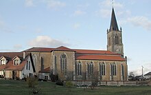
The church of St. George was built in the middle of the 19th century (consecrated in 1866). It replaced the two churches in the districts of Saint-Georges and Saint-Amand, which were now too small and partially dilapidated.
Economy and Infrastructure
After abandoning the nearby military base, Saizerais is now primarily the home of many commuters to the industrial areas in the Moselle valley and to Nancy . There are also smaller craft and service companies in the village. In addition, eight farms are located in the community (grain cultivation, poultry farming)
The community has a post office, a day care center and is a primary school location.
Photovoltaic system
The EDF subsidiary EDF-NE ( Énergies Nouvelles ) leased the entire former military site from the French Ministry of Defense for around € 1 million per year for 22 years. The world's largest photovoltaic system is to be built here on 400 hectares . Construction is scheduled to start in autumn 2011. With a peak output of 143 MW, the plant will be able to supply a city of 62,000 with electricity.
Around 150 jobs will be created during the construction phase, which will benefit Saizerais and other surrounding communities. In addition, buildings are being removed from asbestos and parts of the site are reforested. Finally, a museum will be set up as a future tourist aspect, which will also show formerly stationed military aircraft.
Transport links
Saizerais is located on the road from Rosières-en-Haye to Marbache on the Moselle , other roads lead to the neighboring communities Liverdun and Villers-en-Haye . The national road 411 ( E 23 ) leads from Toul to Dieulouard through the north-west of the municipality . A few kilometers east of Saizerais there are connections to the Autobahn 31 (Luxemburg-Metz-Nancy-Langres). The train station in nearby Marbache is on the Frouard - Novéant line (as part of the Nancy - Metz connection ).
supporting documents
- ^ History of Saizerais in contributions by Samuel Germain, M. Boulangé and Pascal Beau on saizerais.free.fr/histoire. (No longer available online.) Formerly in the original ; Retrieved January 30, 2011 (French). ( Page no longer available , search in web archives ) Info: The link was automatically marked as defective. Please check the link according to the instructions and then remove this notice.
- ↑ 60 years of aviation, article by Pascal Beau on saizerais.free.fr. (No longer available online.) Formerly in the original ; Retrieved January 30, 2011 (French). ( Page no longer available , search in web archives ) Info: The link was automatically marked as defective. Please check the link according to the instructions and then remove this notice.
- ↑ Saizerais on cassini.ehess.fr
- ↑ Saizerais on insee.fr
- ^ Farmers on annuaire-mairie.fr
- ↑ EDF investment in Toul-rosières photovoltaic system. Retrieved January 30, 2011 (French).


