
Ville-au-Val
| Ville-au-Val | ||
|---|---|---|

|
|
|
| region | Grand Est | |
| Department | Meurthe-et-Moselle | |
| Arrondissement | Nancy | |
| Canton | Entre Seille et Meurthe | |
| Community association | Bassin de Pont-à-Mousson | |
| Coordinates | 48 ° 51 ' N , 6 ° 7' E | |
| height | 195-377 m | |
| surface | 17 km 2 | |
| Residents | 197 (January 1, 2017) | |
| Population density | 12 inhabitants / km 2 | |
| Post Code | 54380 | |
| INSEE code | 54569 | |
| Website | http://villeauval.com/ | |

Ville-au-Val is a French commune with 197 inhabitants (as of January 1, 2017) in the Meurthe-et-Moselle department in the Grand Est region (until 2015 Lorraine ). It belongs to the Arrondissement of Nancy and the canton of Entre Seille et Meurthe (until 2015: canton of Pont-à-Mousson ).
geography
Ville-au-Val is located about 18 kilometers north-northwest of Nancy in a side valley of the Moselle . Ville-au-Val is surrounded by the neighboring municipalities of Sainte-Geneviève in the north, Landremont in the north and north-east, Belleau in the east, Millery in the south and south-east, Autreville-sur-Moselle in the south and south-west and Bezaumont in the west and north-west.
Population development
| year | 1962 | 1968 | 1975 | 1982 | 1990 | 1999 | 2006 | 2013 |
| Residents | 146 | 121 | 117 | 134 | 136 | 147 | 167 | 195 |
| Source: Cassini and INSEE | ||||||||
Attractions
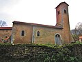
- Saint-Pierre-aux-Liens church from the 19th century
- Castle ruins from the 11th century, today's building from the 17th / 18th century. century
- Villers-les-Prud'homme castle from the 13th / 14th centuries century
- Chapel in Villers-les-Prud'homme

Saint-Pierre-aux-Liens church

Castle and chateau Villers-les-Prud'homme
Chapel in Villers-les-Prud'homme


Personalities
- François Antoine Louis Bourcier (1760–1826), general