Villers-lès-Nancy
| Villers-lès-Nancy | ||
|---|---|---|

|
|
|
| region | Grand Est | |
| Department | Meurthe-et-Moselle | |
| Arrondissement | Nancy | |
| Canton | Laxou | |
| Community association | Grand Nancy | |
| Coordinates | 48 ° 40 ′ N , 6 ° 9 ′ E | |
| height | 224-381 m | |
| surface | 9.95 km 2 | |
| Residents | 14,415 (January 1, 2017) | |
| Population density | 1,449 inhabitants / km 2 | |
| Post Code | 54600 | |
| INSEE code | 54578 | |
| Website | http://www.villerslesnancy.fr/ | |
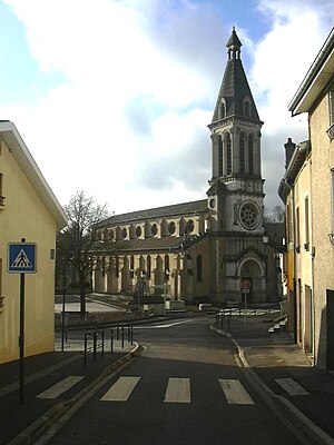
 Saint-Fiacre church |
||
Villers-lès-Nancy is a French commune with 14,415 inhabitants (as of January 1, 2017) in the Meurthe-et-Moselle department in the Grand Est region (until 2015 Lorraine ). It belongs to the Arrondissement of Nancy and the Canton of Laxou .
geography
Villers-lès-Nancy is located in the metropolitan area southwest of Nancy . Neighboring municipalities are Laxou in the north, Nancy in the northeast, Vandœuvre-lès-Nancy in the southeast, Chavigny in the south and Chaligny in the west.
Population development
| year | 1968 | 1975 | 1982 | 1990 | 1999 | 2006 | 2010 |
| Residents | 7,811 | 14,084 | 16,120 | 16,515 | 15,694 | 15,075 | 14,341 |
Town twinning
- Oerlinghausen in North Rhine-Westphalia, Germany
Web links
Commons : Villers-lès-Nancy - Collection of images, videos and audio files
