
Büchel (Eifel)
| coat of arms | Germany map | |
|---|---|---|

|
Coordinates: 50 ° 10 ' N , 7 ° 5' E |
|
| Basic data | ||
| State : | Rhineland-Palatinate | |
| County : | Cochem cell | |
| Association municipality : | Elms | |
| Height : | 453 m above sea level NHN | |
| Area : | 12.84 km 2 | |
| Residents: | 1168 (Dec. 31, 2019) | |
| Population density : | 91 inhabitants per km 2 | |
| Postal code : | 56823 | |
| Area code : | 02678 | |
| License plate : | COC, ZEL | |
| Community key : | 07 1 35 018 | |
| Association administration address: | Marktplatz 1 56766 Ulmen |
|
| Website : | ||
| Local Mayor : | Tino Pfitzner | |
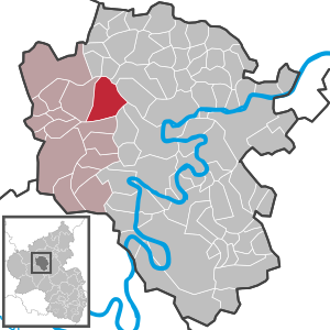
| Location of the local community Büchel in the district of Cochem-Zell | ||
  |
||

Büchel is a municipality in the Cochem-Zell district in Rhineland-Palatinate . It belongs to the Ulmen community and is the only location in Germany where nuclear weapons are stored.
geography
The Büchelermühle and Haykreuzerhof residential areas also belong to Büchel .
climate
The annual precipitation is 877 mm. The rainfall is high. They are in the upper quarter of the values recorded in Germany. Lower values are registered at 75% of the measuring stations of the German Weather Service . The driest month is September, with the most rainfall in November. In November there is 1.7 times more rainfall than in September. The rainfall varies moderately. Lower seasonal fluctuations are recorded at 62% of the measuring stations .
history
In 1141, Martental, located in the area of today's municipality, was first mentioned in a document as a monastery. A farm in Morschweiler is mentioned around the year 1238. 1476, the high court occupant of Alflen proceeded (including Georg Weiler and rotten Weiler) under the Kurtrierer state jurisdiction. In 1794 it was occupied by French revolutionary troops . In 1815 the places were assigned to the Kingdom of Prussia at the Congress of Vienna . In 1873 Büchel became a parish, the Georgsweiler and Morschweiler settlements belong to Büchel. Büchel has been part of the then newly formed state of Rhineland-Palatinate since 1946.
In 2012, 84.7 percent of the population were Catholic and 5.7 percent Protestant. The rest belonged to another religion or were non-denominational.
politics
Local council
The council in Büchel consists of 16 council members, who in the local elections on May 26, 2019 in a majority vote were elected, and the honorary mayor as chairman.
Local mayor
Since no candidate had been found for the primary election on May 26, 2019, the municipal council elected Tino Pfitzner as local mayor at its constituent meeting in July 2019.
coat of arms
|
|
Blazon : “Through a curled point up to the head of the shield, in it seven black crosses in silver, split; in front a silver tower growing in green; behind in red a silver column cross with a base growing out of the edge. " |
Economy and Infrastructure
The Büchel Air Base was west of the community after the Second World War, built by the French occupation army and in 1955 transferred to the federal government. Around 20 US type B61 nuclear weapons are stored in the bunkers at the Büchel site . Since July 2007, the air base has been the only location in Germany with nuclear weapons.
There is a kindergarten, a primary school and a gym in the village.
The federal road 259 runs through Büchel .
Personalities

- Hermann Nebel (1816–1893), German architect and master city architect in Koblenz. Built 1859–1863 the Catholic Church of St. Simon and Juda in Büchel (apart from the tower, demolished in 1957 and rebuilt).
See also
Web links
- Website of the local community Büchel
- Literature about Büchel in the Rhineland-Palatinate State Bibliography
Individual evidence
- ↑ State Statistical Office of Rhineland-Palatinate - population status 2019, districts, communities, association communities ( help on this ).
- ↑ State Statistical Office Rhineland-Palatinate (ed.): Official directory of the municipalities and parts of the municipality. Status: January 2018 [ Version 2020 is available. ] . S. 23 (PDF; 2.2 MB).
- ↑ KommWis, as of October 31, 2012
- ^ The Regional Returning Officer RLP: City Council Election 2019 Büchel. Retrieved August 21, 2019 .
- ^ Daniel Rühle: Mayor at the age of 30. Rhein-Zeitung, July 11, 2019, accessed on August 21, 2019 .
- ^ Otfried Nassauer: US nuclear weapons in Germany and Europe
- ^ Report in Spiegel Online from July 9, 2007

Alf | Alflen | Altlay | Alt-trimmed | Auderath | Bad Bertrich | Beilstein | Beuren | Binningen | Blankenrath | Brachtendorf | Bremm | Briedel | Brieden | Briedern | Brohl | Bruttig-Fankel | Büchel | Bullay | Cochem | Dohr | Durfus | Düngenheim | Ediger-Eller | Ellenz-Poltersdorf | Eppenberg | Serious | Eulgem | Faid | Felt | Forst (Eifel) | Forst (Hunsrück) | Gamling | Gevenich | Gillenbeuren | Greimersburg | Grenderich | Hambuch | Haserich | Hauroth | Hesweiler | Illerich | Kaifenheim | Kail | Kaisersesch | Kalenborn | Kliding | Klotten | Country core | Laubach | Leienkaul | Lie | Liesenich | Lütz | Lutzerath | Masburg | Mesenich | Medium- bodied | Möntenich | Moritzheim | Mosel core | Tired (Moselle) | Müllenbach | Neef | Nehren | Panzweiler | Peterswald -öffelscheid | Pomerania | Pünderich | Reidenhausen | Roes | Sankt Aldegund | Showers | Schmitt | Senheim | Sosberg | Tellig | Treis cards | Elms | Urmersbach | Urschmitt | Valwig | Wagenhausen | Walhausen | Hamlet | Wirfus | Wollmerath | Zell (Mosel) | Zettingen