
Federal motorway 73
| Federal motorway 73 in Germany | |||||||||||||||||||||||||||||||||||||||||||||||||||||||||||||||||||||||||||||||||||||||||||||||||||||||||||||||||||||||||||||||||||||||||||||||||||||||||||||||||||||||||||||||||||||||||||||||||||||||||||||||||||||||||||||||||||||||||||||||||||||||||||||||||||||||||||||||||||||||||||||||||||||||||||||||||||||||||

|
|||||||||||||||||||||||||||||||||||||||||||||||||||||||||||||||||||||||||||||||||||||||||||||||||||||||||||||||||||||||||||||||||||||||||||||||||||||||||||||||||||||||||||||||||||||||||||||||||||||||||||||||||||||||||||||||||||||||||||||||||||||||||||||||||||||||||||||||||||||||||||||||||||||||||||||||||||||||||
| map | |||||||||||||||||||||||||||||||||||||||||||||||||||||||||||||||||||||||||||||||||||||||||||||||||||||||||||||||||||||||||||||||||||||||||||||||||||||||||||||||||||||||||||||||||||||||||||||||||||||||||||||||||||||||||||||||||||||||||||||||||||||||||||||||||||||||||||||||||||||||||||||||||||||||||||||||||||||||||
 |
|||||||||||||||||||||||||||||||||||||||||||||||||||||||||||||||||||||||||||||||||||||||||||||||||||||||||||||||||||||||||||||||||||||||||||||||||||||||||||||||||||||||||||||||||||||||||||||||||||||||||||||||||||||||||||||||||||||||||||||||||||||||||||||||||||||||||||||||||||||||||||||||||||||||||||||||||||||||||
| Basic data | |||||||||||||||||||||||||||||||||||||||||||||||||||||||||||||||||||||||||||||||||||||||||||||||||||||||||||||||||||||||||||||||||||||||||||||||||||||||||||||||||||||||||||||||||||||||||||||||||||||||||||||||||||||||||||||||||||||||||||||||||||||||||||||||||||||||||||||||||||||||||||||||||||||||||||||||||||||||||
| Operator: |
|
||||||||||||||||||||||||||||||||||||||||||||||||||||||||||||||||||||||||||||||||||||||||||||||||||||||||||||||||||||||||||||||||||||||||||||||||||||||||||||||||||||||||||||||||||||||||||||||||||||||||||||||||||||||||||||||||||||||||||||||||||||||||||||||||||||||||||||||||||||||||||||||||||||||||||||||||||||||||
| Overall length: | 170 km | ||||||||||||||||||||||||||||||||||||||||||||||||||||||||||||||||||||||||||||||||||||||||||||||||||||||||||||||||||||||||||||||||||||||||||||||||||||||||||||||||||||||||||||||||||||||||||||||||||||||||||||||||||||||||||||||||||||||||||||||||||||||||||||||||||||||||||||||||||||||||||||||||||||||||||||||||||||||||
|
State : |
|||||||||||||||||||||||||||||||||||||||||||||||||||||||||||||||||||||||||||||||||||||||||||||||||||||||||||||||||||||||||||||||||||||||||||||||||||||||||||||||||||||||||||||||||||||||||||||||||||||||||||||||||||||||||||||||||||||||||||||||||||||||||||||||||||||||||||||||||||||||||||||||||||||||||||||||||||||||||
 |
|||||||||||||||||||||||||||||||||||||||||||||||||||||||||||||||||||||||||||||||||||||||||||||||||||||||||||||||||||||||||||||||||||||||||||||||||||||||||||||||||||||||||||||||||||||||||||||||||||||||||||||||||||||||||||||||||||||||||||||||||||||||||||||||||||||||||||||||||||||||||||||||||||||||||||||||||||||||||
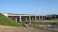
| A 73 - Main crossing at Lichtenfels | |||||||||||||||||||||||||||||||||||||||||||||||||||||||||||||||||||||||||||||||||||||||||||||||||||||||||||||||||||||||||||||||||||||||||||||||||||||||||||||||||||||||||||||||||||||||||||||||||||||||||||||||||||||||||||||||||||||||||||||||||||||||||||||||||||||||||||||||||||||||||||||||||||||||||||||||||||||||||
|
Course of the road
|
|||||||||||||||||||||||||||||||||||||||||||||||||||||||||||||||||||||||||||||||||||||||||||||||||||||||||||||||||||||||||||||||||||||||||||||||||||||||||||||||||||||||||||||||||||||||||||||||||||||||||||||||||||||||||||||||||||||||||||||||||||||||||||||||||||||||||||||||||||||||||||||||||||||||||||||||||||||||||
The federal autobahn 73 (abbreviation: BAB 73 ) - short form: Autobahn 73 (abbreviation: A 73 ) is a German autobahn that connects the southern Thuringian city of Suhl with the central Franconian city of Nuremberg . In the development area of the autobahn, it is also known colloquially as the Frankenschnellweg .
The A 73 begins at the Suhl ( A 71 ) motorway junction and initially leads via Coburg and Lichtenfels to Bamberg. The Suhl – Lichtenfels section was built as part of the German Unity Transport Project No. 16 and has been continuously passable since September 5, 2008. The new line cost around 794 million euros. It has a space requirement of 1557 hectares, which consists of 590 hectares of traffic areas and 967 hectares of compensation areas.
Between Schleusingen and Coburg-Nord and between Bamberg and Erlangen , the A 73 runs parallel and close to the B 4 or the old route of the B 4 and partially replaces it.
Section Suhl – Eisfeld
The 34 kilometer long section of the A 73 in Thuringia has the standard cross section (RQ) 26 and is characterized by a series of large bridges due to the difficult topography on the edge of the Thuringian Forest. Of the 17 large bridges on the Thuringian side with a total length of 6.6 kilometers, the first south of the Suhl motorway triangle, the Haseltal viaduct , is to be highlighted. This girder bridge has a total length of 845 meters and spans the Suhl district of Heinrichs with the former Simson plant at a height of 82 meters with pillar spacing of a maximum of 175 meters. The blue paint on the steel structure sparked some discussion. Construction of the Suhl – Schleusingen section began in 2003. The section to Suhl-Friedberg was opened to traffic in mid-2006, although the Suhl-Zentrum junction was only accessible in December 2007. The completion up to Schleusingen followed at the end of 2006. The Schleusingen – Eisfeld-Nord section was tackled in 2004 and opened to traffic on July 25, 2008.

Nahe valley bridge south of AS Schleusingen in May 2008


Section Eisfeld – Coburg – Lichtenfels


In December 2002 the first section from Eisfeld-Süd to Coburg was released. The Eisfeld-Süd junction is exactly on the former inner-German border. As a result, it interrupts a longer section of the German Green Belt than if the junction had been created a little further north or south, and disrupts the biotope network between the Baltic Sea near Lübeck and the border triangle Bavaria - Saxony - Czech Republic (formerly FRG - GDR - CSSR as the end point the inner-German border).
Shortly before the opening of the section between Eisfeld-Nord and Eisfeld-Süd at the end of 2003, it was found that the clearance height of the Eisfeld-Süd flyover was not the required 4.7 meters, but was only 4.45 meters at the edge. Therefore, the completed south-facing carriageway had to be lowered accordingly over a length of 300 meters.
The A 73 leads north of Coburg around the city to Rödental, Ebersdorf and Lichtenfels. The roughly three kilometer long section from Coburg to the Rödental junction was opened on October 31, 2006. Until this section was cleared (to Rödental), the transition to the B 4 served as the Coburg motorway exit. Since then, the junction in the direction of Rödental has been linked as a triangle with the B 4 in two lanes, as it connects two sections of the B 4 in this section.
The 8.5-kilometer section of the A 73 from Rödental to Ebersdorf has been accessible since October 19, 2007. The last section between Ebersdorf and Lichtenfels was opened to traffic on September 5, 2008. The Lichtenfels junction is partially linked to the B 173 with two lanes. The B 4 is connected to the Untersiemau junction by the newly built feeder ( B 289 ). Between the Untersiemau junction and the Lichtenfels Nord junction, drivers can enjoy a view of the Vierzehnheiligen basilica . The section between Ebersdorf and Lichtenfels was controversial because the route cuts through the " Gottesgarten " located between Bad Staffelstein and Lichtenfels below the Banz monastery and the Lichtenfels forest . In the summer of 2003, the Federal Administrative Court dismissed a lawsuit from the BUND nature conservation association , clearing the way for the crossing of the Main floodplain.
In July 2010, a speed limit of 120 km / h was introduced on the section between the Lichtenfels junction and the Untersiemau junction for safety reasons.
Itztal Bridge in September 2007
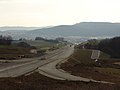
View from AS Untersiemau towards Lichtenfels in January 2008

Bridge for the LIF2 district road at AS Lichtenfels Nord in September 2008

Junction (9) Coburg 2006


Lichtenfels – Bamberg section
This section was part of the federal highway 173 and had already been expanded to four lanes. However, at a cost of around 50 million euros, the hard shoulder had to be supplemented on both sides and the superstructure reinforced. At the beginning of December 2007, signs with a blue background were consistently marked, with the designation of the connection points Bad Staffelstein-Ost in Bad Staffelstein and Bad Staffelstein-Nord in Bad Staffelstein-Kurzentrum being changed. On January 1, 2008, the official upgrade to the Autobahn took place. Due to inconsistencies and jumps, the operating kilometers were changed on September 4, 2008 in the section south of Lichtenfels. The kilometers of the autobahn begin at Suhl and end at kilometer 154 on the city limits of Nuremberg.
Bamberg – Nuremberg section

The section between Bamberg and Nuremberg was built between 1967 and 1986, whereby the Nuremberg - Fürth - Erlangen section, built from 1967 to 1972, is by far the oldest of the A73 and was originally opened as the B4a, but had motorway standard from the start. The further construction of the A 73 near Bamberg was controversial for a long time, as it cuts up a large contiguous forest area, the main moor forest .
Between Forchheim-Süd and Erlangen-Zentrum, the four-lane motorway regularly reached its capacity limit with over 60,000 vehicles per day, especially during rush hour, even before the connection to Thuringia was completed. For this reason, the hard shoulder is being expanded as a third, temporary lane in several construction phases on this section. In October 2007 the expanded hard shoulder and the electronic traffic control systems between Möhrendorf and Erlangen-Nord were completed, so that after a three-month trial run in this area, the hard shoulder can be opened for traffic since January 2008 if necessary. From April to October 2008, the expansion to Baiersdorf-Nord was continued. The hard shoulder release in this area went into operation at the end of December 2008 after a test phase in blind operation. From May 2015 onwards, the hard shoulder release between Forchheim-Süd and Baiersdorf-Nord was built; the work was completed in December 2015. In the opposite direction, the structural requirements for the temporary hard shoulder clearance between Erlangen and Forchheim have been created since June 2016.
In the Erlangen-Nord to Erlangen-Zentrum section, the previous hard shoulder can now be used as a permanent interwoven lane. In the last few years in the city of Erlangen, hard shoulders have been converted into interlacing strips in several sections. This took place in the areas Erlangen-Zentrum to Erlangen-Bruck (both directions), Erlangen-Bruck to the Fürth / Erlangen motorway junction (both directions) and Erlangen-Zentrum to Erlangen-Nord.
In the Erlangen, Fürth and Nuremberg area, the Frankenschnellweg largely follows the former route of the Ludwig-Danube-Main Canal . In 2013 the Fürth-Steinach exit was built between the Erlangen-Eltersdorf and Fürth-Ronhof exits and opened in December of the same year. It was necessary in order to relieve the traffic in Steinach, as a strong increase in traffic in this district was to be expected due to a newly built branch of the Höffner furniture chain . Noise barriers were also erected to reduce traffic noise by ten decibels . The section between the Nürnberg / Fürth and Nürnberg-Hafen junctions has only been dedicated as a district road since 2007 ; there the official Nuremberg street name is Frankenschnellweg. In the area of the Nürnberg-Gostenhof exit, the route is interrupted for a distance of around 500 m by three crossings or junctions that are regulated by traffic lights. When there is a high volume of traffic, the An den Rampen / Rothenburger Straße area is usually overloaded, while longer congestion areas (especially strong from the north / west) form on both sides of the Frankenschnellweg during rush hour, as the throughput of the traffic lights cannot cope with the volume of traffic. There are often rear-end collisions at the ends of the traffic jam, which is why a speed limit of 60 km / h is already signposted from the exits Nürnberg Westring and Nürnberg Südring. In addition, until September 2004 there were regular accidents with trucks that got stuck in the An den Rampen area (a railway bridge with a height of 3.70 m) despite electronic warning signs. Lowering the road by 30 cm has at least solved the problem with the truck getting stuck; nevertheless, local people tend to avoid the area during the day. Nuremberg is because of traffic jams in rush hour also spoke jokingly of "Frankenstauweg" or "Frankenschleichweg".
From autumn 2012 at the earliest, this part should be expanded to be free of intersections and the motorway should cross the urban area in a tunnel in some sections ("Frankenröhre"). The underground station Rothenburger Straße , located below the street, was built deep enough in the 1980s to accommodate a street tunnel. The start of construction was delayed until after 2016 due to appeals from the Federal Nature Conservation Association at the Ansbach Administrative Court in 2014.
In this area there are some efficient connection points with only one intersection on the feeder road .
While the Frankenschnellweg crosses the Nürnberg-Hafen junction as the N4 district road in a straight line and continues to the Nürnberg-Eibach junction, the restart of the A73 is there in a south-west direction at the Nürnberg-Hafen Ost junction of the south-west bypass . It crosses the A 6 at the Nürnberg-Süd junction and joins the A 9 a few kilometers further south at the Nürnberg / Feucht triangle and ends there. In the area of the motorway triangle, the motorway crosses the high-speed railway line Nuremberg – Ingolstadt – Munich .
Wildlife crossing protection
The A 73 is secured against game passage on the entire route between Suhl and Lichtenfels by continuous fences on both sides . In the case of newly released sections, it happened that the deer crossing protection fences were not yet in place, but were only installed later.
Numerous field and forest path underpasses as well as the valley bridges of the A73 enable the safe passage of game. Among other things, there is a special animal passage between Schleusingen and Eisfeld .
Others
Although the oldest sections are in the Nuremberg / Fürth / Erlangen area and the southern part Bamberg - Nuremberg was completed long before the northern part, the kilometrage and junction counts run from north to south.
The overpass structures in the new section between Eisfeld-Süd and Lichtenfels were all seamless . These include the 127 meter long prestressed concrete girder bridge for the overpass of the Unterlauter –Dörfles municipal road and the 101.8 meter wide steel truss bridge for the LIF 2 district road.
East of Bamberg between Memmelsdorf (22) and Bamberg-Ost (23) there was a junction that was only used for military purposes. It was a direct link to the American military area of the Warner Barracks .
Between the junctions Nürnberg / Fürth (39) and Kreuz Nürnberg-Hafen, the route is not dedicated to the city of Nürnberg as a federal motorway, but as the N4 district road. It is officially called Frankenschnellweg there and continues via the Nürnberg-Hafen junction and the Nürnberg-Eibach junction in the direction of Reichelsdorf (former planning for the federal motorway 77/751 ). The section between the Nürnberg / Fürth junction and the intersection with Rothenburger Strasse is nevertheless signposted in blue as a motorway. In the section between the junction at Kreuz Nürnberg-Hafen and Nürnberg-Hafen Ost, the route is part of the Südwesttangente and is dedicated as a municipal road. No truck toll has to be paid for the sections designated as district and municipal roads .
In the Erlangen – Nuremberg section, the autobahn was also designated as Bundesstraße 4a and Bundesautobahn 753 during the planning period and was also opened as B4a.
Trivia
As of January 1, 2016, the following were responsible for the A 73:
- Free State of Thuringia
- in the area between the Suhl motorway triangle (1) and the state border at the Zella-Mehlis motorway maintenance authority
- Free State of Bavaria
- in the area between the state border of and junction Ebersdorf b.Coburg (10) at the Coburg / Kronach road maintenance department,
- in the area between the junction Ebersdorf near Coburg (10) and the junction Breitengüßbach-Nord (18) at the Bad Staffelstein road maintenance depot,
- in the area between the Breitengüßbach-Nord junction (18) and Möhrendorf junction (30) at the Thurnau / Hirschaid motorway maintenance facility,
- in the area of the Möhrendorf junction (30) and the Nürnberg / Fürth junction (39) at the Erlangen / Neumarkt i. d. Upper Palatinate.
literature
- Federal Ministry for Transport, Building and Development; Bavarian State Ministry - Supreme Building Authority; Thuringian Ministry of Construction and Transport: Federal motorway A 73 Suhl – Lichtenfels . Documentation 2008.
Web links
- Information page of the Bavarian State Ministry of the Interior about the A 73
- Detailed route description of the federal highway 73
Individual evidence
- ↑ Silberling and flat iron: 1000 nicknames in transport and traffic and what's behind them. Richard Deiss , accessed January 16, 2019 .
- ↑ Frankenschnellweg: Less traffic jams or even more traffic? Franconian Day , July 14, 2014, accessed on June 21, 2016 .
- ^ Coburger Tageblatt, September 6, 2008
- ↑ The work is now done . In: Free Word from July 26, 2008 ( Memento from September 2, 2008 in the Internet Archive )
- ↑ Autobahn Directorate North Bavaria press release No. 22/08 of August 29, 2008
- ↑ Grand opening of the Autobahn exit to Möbel Höffner. In nn-online. 18th December 2013.
- ↑ Documents on item 7 of the agenda of the 60th meeting of the building and awarding committee of the city of Nuremberg on November 13, 2007
- ↑ http://www.nuernberg.de/internet/soer/fsw_startseite.html
- ↑ Expansion of the Franconian Expressway is delayed by years. In: Süddeutsche Zeitung . June 24, 2015.
- ↑ Areas of responsibility of the motorway maintenance depots in Thuringia. Thuringian State Office for Building and Transport, September 2016, accessed on October 3, 2016 .
- ^ Free State of Bavaria - Road overview map - Responsibilities of the motorway maintenance authorities. In: baysis.bayern.de. Supreme building authority in the Bavarian State Ministry of the Interior, for Building and Transport, January 1, 2016, accessed on September 17, 2016 (PDF; 2.9 MB).
