
Federal motorway 41
| Bundesautobahn 41 in Germany | |

|
|
| map | |
 |
|
| Basic data | |
| Operator: |
|
|
State : |
|
| Status: | Planning discarded |
Bundesautobahn 41 (abbreviation: BAB 41 ) - short form: Autobahn 41 (abbreviation: A 41 ) - was the project name for a planned motorway that was introduced with effect from January 1, 1975, from the A 31 near Rhade via Gelsenkirchen and Bochum to the A 43 should leadat Sprockhövel . With the Federal Transport Infrastructure Plan 1980, the planning was discarded. From the A 41, only a five kilometers long section between was Gelsenkirchen-Buer and the junction Dorsten -Ost over the A52 built as a freeway.
Planning history
In the 1971 plan for the expansion of the federal highways from 1971 to 1985, the route later called "Bundesautobahn 41" was planned as a new construction project for three federal highways:
| Short name | section | expansion | Urgency level |
|---|---|---|---|
| B 224n | Triangle with the A 113 (today: A 31) at Rhade - Dorsten - Kreuz with the B 1120 (later: A 40 or Lipperand motorway) | four-lane expansion, | I. |
| B 227n | Cross with the B 1120 (later: A 40 or Lipperandautobahn) - Gelsenkirchen - Cross with the B 1 (today: A 40 ) near Bochum | six-lane expansion, | I. |
| B 51 | Cross with the B 1 near Bochum - Hattingen - cross with the A 77 (today: A 43) near Sprockhövel, | six-lane expansion, | II |
In accordance with the urgency levels set for the construction of these federal highways, concrete plans existed for the section Rhade (A 113, today: A 31) - Dorsten - Gelsenkirchen - Bochum- Höntrop (L 654), while only one was insufficient for the subsequent southern section certain lines existed.
The following route was planned for the northern section:
Bundesstrasse 224n :
- Triangle with A 113 (today: A 31) near Rhade north of the Borken - Dorsten railway line
- east of Deuten ( B 58 ) and west of Wulfen
- southwest of Wulfen across the area east of Dorsten- Hervest to today's AS Dorsten-Ost (essentially corresponds to the existing state road 608)
- AS Dorsten-Ost - junction with the B 1120 or A 40 "Lipperandautobahn" (today completed section and designated as A 52)
Bundesstrasse 227n :
- Cross with the B 1120 (later referred to as A 40 or Lipperandautobahn) to the triangle with the B 224 north of the Gelsenkirchen-Scholven junction (now completed section dedicated to the A 52)
- south of Gelsenkirchen-Hassel and north of Gelsenkirchen-Buer
- east of Gelsenkirchen-Buer and southwest of Herten-Westerholt (with connection to the L 511)
- west of Gelsenkirchen-Resse (with connection to the K 4 at Resse and Kreuz with the A 2 in the area of today's service area "Resser Mark")
- east of Gelsenkirchen-Erle (with connection to K 11 / Willy-Brandt-Allee)
- west of Gelsenkirchen-Bismarck (junction with the A 42 at today's AS Gelsenkirchen-Schalke )
- west of Gelsenkirchen-Bulmke-Hüllen and east of Gelsenkirchen-Altstadt (with connection to the L 639 / Florastraße)
- west of the former Thyssen steelworks Schalker Verein (with connection to the L 627)
- west of Gelsenkirchen- Ückendorf and east of Gelsenkirchen-Neustadt
- west of Gelsenkirchen-Süd and west of Leithe (mainly on the route of the B 227 / Hattinger Straße)
- east of the AS Gelsenkirchen-Süd (junction with the B 1 , today: A 40 )
The southern section should be built on the following line:
Bundesstrasse 51 :
- east of the AS Gelsenkirchen-Süd (junction with the B 1 , today: A 40 )
- to the west of Essen-Freisenbruch and to the east of Höntrop
- east of Essen-Horst and west of Dahlhausen
- Burgaltendorf
- Niederwenigern
- west and south of Hattingen
- Bredenscheid
- Obersprockhövel
- south of AS Sprockhövel (junction with the A 77, today's A 43)
With the restructuring of the motorway numbering from January 1, 1975, the new construction projects for the B 224n, the B 227n and the B 51 between Rhade (A 31) and Sprockhövel (A 43) were combined to form a single route under the name "Bundesautobahn 41".
According to the first law of August 5, 1976 amending the law on the expansion of federal trunk roads from 1971 to 1985 (Federal Law Gazette 1976, Part I, p. 2093), the A 41 was almost completely assigned to possible further needs. Only a short section between AS Gelsenkirchen-Hassel and AS Dorsten-Ost was assigned to urgency level Ia.
With the second law of 25 August 1980 amending the law on the expansion of federal highways from 1971 to 1985 (Federal Law Gazette 1980, Part I, p. 1614), the A 41 was deleted from the requirement plan. In particular, no replacement plans were made on the previous route of the A 41, e.g. B. in the form of two- or four-lane federal roads are provided.
A resumption of the route by the Third Act of April 21, 1986 amending the Act on the Expansion of Federal Highways (Federal Law Gazette 1986, Part I, p. 557) and the Fourth Act on the Amendment of the High Road Expansion Act of November 15, 1993 (BGBl. 1993, Part I, p. 1877) did not take place. The A 41 also did not contain the requirement plans of both laws.
The A 41 is still not included in the federal transport infrastructure plans for 2003 and 2015.
Between Dorsten / Wulfen and AS Dorsten-Ost, the planning was taken up by the state of North Rhine-Westphalia and implemented as state road 608.
Completed sections
In 1974 a first section of the new building planned as the B 227n between AS Gelsenkirchen-Hassel and the junction north of AS Gelsenkirchen-Scholven was opened to traffic.
In 1977 construction began on the section between AS Dorsten-Ost and AS Gelsenkirchen-Hassel under the designation "A 41", which was completed in 1980. However, the dedication was initially neither as a federal motorway nor as a federal road, but as a state road. It was only later that it was rededicated to the A 52. AS Dorsten-Ost was initially designed in such a way that the carriageways of the A 41 in the direction of Wulfen could later be built: the carriageways of today's A 52 ran separately from each other in this area and with corresponding curves for the access and exit ramps for the connection to the A 41. However, this preliminary construction work was reduced in the course of the new construction of the L 608 to Dorsten / Wulfen and the associated redesign of the AS Dorsten-Ost.
On the other hand, the preliminary construction work between the junctions Gelsenkirchen-Hassel and Gelsenkirchen-Scholven for the once planned Gelsenkirchen-Buer-Nord motorway triangle was retained: the two lanes are separated here and the hard shoulder is extra wide.
Another preliminary construction work can be found in the area of today's Gelsenkirchen-Schalke junction of the A 42 . The bridges for the parallel lanes at the Gelsenkirchen motorway junction have already been laid there.
The following sections on the original route of the A 41 have been completed:
- AS Gelsenkirchen-Hassel - planned AD north of AS Gelsenkirchen-Scholven: 1974 (1.5 km; later dedicated as A 52)
- AS Dorsten-Ost - AS Gelsenkirchen-Hassel: 1980 (2.9 km; initially dedicated as a state road, later as A 52)
- north of AS Dorsten-Hervest - AS Dorsten-Ost: 1992/93 (6 km; two lanes, dedicated as L 608)
Individual evidence
- ↑ Construction work on federal trunk roads in 1972. Expansion of federal trunk roads from 1971 to 1985. Annex to the road construction report 1972. Federal Minister of Transport, Road Construction Department, accessed on March 31, 2013 (map excerpt).
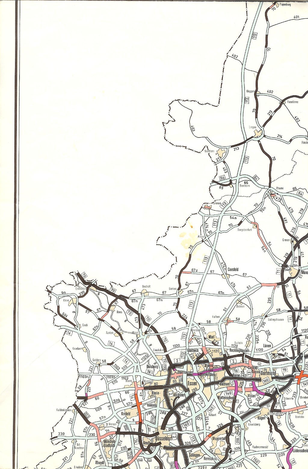
- ↑ The Great Shell Atlas. Germany and Europe 1977/78. Mairs Geographischer Verlag, Stuttgart, new edition 1977/78, sheet 32
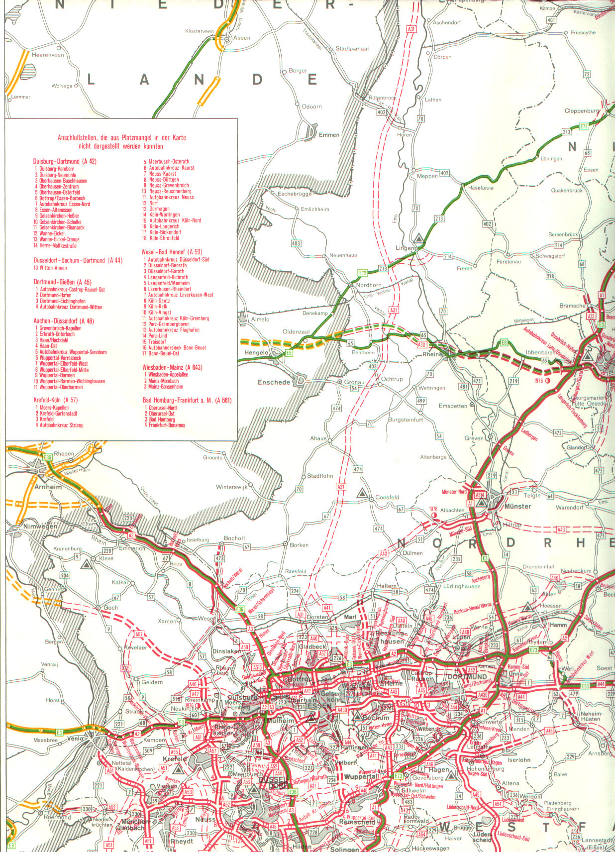
- ↑ Network of federal motorways and federal highways. Status January 1, 1976. Federal Minister of Transport, Road Construction Department, accessed on March 31, 2013 (map excerpt).
Web links
- Detailed route description of the federal motorway 41
- Planned course of the A 41 according to the land use plan of the city of Gelsenkirchen from August 17, 1976
- Photos of the planned Gelsenkirchen-Buer-Nord triangle
