
Federal Motorway 648
| Bundesautobahn 648 in Germany | |||||||||||||||||||||||||

|
|||||||||||||||||||||||||
| map | |||||||||||||||||||||||||
 |
|||||||||||||||||||||||||
| Basic data | |||||||||||||||||||||||||
| Operator: |
|
||||||||||||||||||||||||
| Start of the street: |
Eschborn triangle ( 50 ° 8 ′ N , 8 ° 34 ′ E ) |
||||||||||||||||||||||||
| End of street: |
Messe Frankfurt ( 50 ° 7 ′ N , 8 ° 38 ′ E ) |
||||||||||||||||||||||||
| Overall length: | 5 km | ||||||||||||||||||||||||
|
State : |
|||||||||||||||||||||||||
| Development condition: | 2/2 | ||||||||||||||||||||||||
|
Course of the road
|
|||||||||||||||||||||||||
The Bundesautobahn 648 (abbreviation: BAB 648 ) - short form: Autobahn 648 (abbreviation: A 648 ) - is a motorway in the German state of Hesse . It serves primarily as a feeder route from the A 66 and the A 5 to Frankfurt am Main and is also known as Wiesbadener Straße .
course
The motorway branches off from the A 66 at the Eschborn triangle . In the triangle itself there is no connection from the A 66 from Nordwestkreuz Frankfurt to the A 648. If you want to drive in this direction, you have to take a small detour via the Westkreuz Frankfurt and the A 5 or alternatively the one integrated in the triangle and accessible from the A 66 Junction Eschborn . The A 648 runs east of the Sossenheim district of Frankfurt and has the Frankfurt- Rödelheim junction there , which also connects the Frankfurt district of the same name.
Westkreuz Frankfurt follows. This connects the autobahn to the A 5 , one of the most important traffic routes in Germany. Since the A 648 is the most important feeder into Frankfurt city center, the junction is correspondingly busy. The crossings from the A 5 to the A 648 to the east, i.e. into the city center, have been expanded into two lanes. Furthermore, the cross is not designed in the classic cloverleaf shape, but has two direct ramps (each from the A 5 to the A 648). In addition, the Nidda River flows through the middle of the cross, which is why there are also numerous bridge structures.
After the Westkreuz, the motorway runs through the Bockenheim district and connects with the Frankfurt-Rebstock junction to the site of the same name, which consists of a park, sports facilities and a leisure pool. A petrol station is integrated into the connection point on both sides. There is also an ADAC office on the site of the southern motorway filling station (towards the city center) . Between the Westkreuz Frankfurt and the Frankfurt-Rebstock exit, five lanes are marked in the direction of the center. This is a rarity in Germany. However, minus the access ramps, the section is only approx. 250 m long. Another special feature is that this section is one of the very few in Germany that has lighting systems up to the end of the motorway.
The autobahn ends at the next junction, Katharinenkreisel , and merges into the B 8 , which leads past the exhibition halls and meets the B 44 at the Ludwig-Erhard-Anlage, a large traffic light-regulated roundabout . The Katharinenkreisel was called until 2004 unofficially Opel-Rondell , the name referred to a by the end of the 1980s befindliches at the roundabout Opel - Autohaus .
If you follow the B 44 from Ludwig-Erhard-Anlage, you will arrive at Frankfurt Central Station .

Connection ramp in Westkreuz Frankfurt over the Nidda

Dynamic alternating signposting towards the city center, newly built in 2017. The previous sign indicated the university , whose Bockenheim campus will disappear in the near future.

Motorway end in Frankfurt am Main during the day (2004)
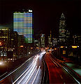
Same place, taken at night (2005)


history
The section between Eschborn and Westkreuz Frankfurt was built in 1954, when the B 40 from Wiesbaden-Erbenheim to Westkreuz was expanded like a motorway. This was upgraded to the Autobahn in 1965 and internally referred to as Bundesautobahn 80 . Today's Eschborn triangle did not exist at that time, so the road made a continuous curve from the direction of Wiesbaden into Frankfurt city center ( Eschborn curve ). It was not until 1972 that the motorway triangle was created as part of the expansion of the Wiesbaden – Frankfurt– Hanau - Fulda motorway via the Frankfurt Northwest Crossing to the current end of the motorway at Miquelallee , which now formed the continuous stretch from which the motorway branched off to Westkreuz.
When a new, uniform motorway numbering was introduced in 1974, the part of Federal Motorway 80 west of Eschborn and the continuation to Miquelallee were renamed Federal Motorway 66 . The motorway branching off to Westkreuz was henceforth called Bundesautobahn 648 .
The section from Westkreuz to the end of the motorway at Katharinenkreisel was expanded as a motorway in the 1970s and completed in 1975. Since then, the entire length of the A 648 has been drivable.
meaning
The A 648 is the most important feeder into Frankfurt city center and the exhibition center and is therefore colloquially known as the exhibition motorway . On average, it is used by around 60,000 vehicles per day over its entire length.
On trade fair days, the traffic routing is mostly changed and the car park on Rebstock can be reached directly. The entire length of the motorway was therefore equipped with variable signposts (prism inverters) in an easterly direction, which could indicate other destinations or change the direction of travel for certain destinations if necessary. In such a case, drivers were alerted by two alternating yellow flashing lights on either side of the signpost.
In 2017, new signposts with LCD surfaces were installed, which means that the signage can be adjusted more flexibly, especially on trade fair days.
Web links
- Detailed route description of the federal motorway 648
- Photo series of the A 648 in the direction of Frankfurt, with changed traffic routing on the wayside
Individual evidence
- ^ New building 1965 , autobahn-online.de, accessed on July 2, 2016
- ^ New building 1975 , autobahn-online.de, accessed on July 2, 2016
- ↑ Manual road traffic census 2010 of the BVM ( Memento from April 19, 2014 in the Internet Archive )
