Hattenbach
|
Hattenbach
Market town of Niederaula
Coordinates: 50 ° 48 ′ 17 ″ N , 9 ° 33 ′ 35 ″ E
|
|
|---|---|
| Height : | 263 m above sea level NHN |
| Area : | 13.5 km² |
| Residents : | 582 (December 31, 2015) |
| Population density : | 43 inhabitants / km² |
| Incorporation : | December 31, 1971 |
| Postal code : | 36272 |
| Area code : | 06625 |
|
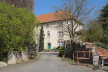
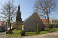
Image detail Hattenbach with church and castle
|
|
Hattenbach is a part of the market town of Niederaula in the Hersfeld-Rotenburg district in East Hesse . It is located in the Waldhessen region on the Hattenbach stream of the same name .
geography
To the west of Hattenbach, the federal highway 7 and the federal highway 5 meet at the Hattenbacher Dreieck . The high-speed line Hanover – Würzburg runs past the village . The Hattenbach valley bridge on this railway line is 308 m long.
history
Archaeological finds suggest a settlement in the Neolithic Age .
The place is mentioned in writing for the first time in a document dated December 17, 1234. A witness from "Haddenbach" is named in it. Until 1803 the village had its own jurisdiction as an independent office . When it then came to the Niederaula office, it lost this privilege. In 1766, 381 people lived in Hattenbach.
In 1235 the first noble family of the von Hattenbach is mentioned in Hattenbach. It expired in 1626. The von Peterswald family then followed until 1664 as landgrave owners of the place. The fiefdom reverted to the Hessian landgraves in 1651 , and Ernst Reinhard, an illegitimate son of the Landgrave Hereditary Prince Otto , born posthumously in 1617 , was enfeoffed with the place in 1654, then called himself Ernst von Hattenbach and thus founded a second noble family of the von Hattenbach family . Around 1672 he had a castle built on the remains of the former castle , which his son expanded again in 1713–1715 and also received an orangery . The second noble family died out in 1786.
Until around 1840 the owners of the castle changed several times, when Eduard von Biedenfeld bought it . His widow sold the estate and castle Hattenbach on September 25, 1854 to the former Hessian Minister of State. D. Georg Ferdinand von Lepel (1779–1873). His son Carl (1821-1901) was followed by his son Emil, who in 1892 sold to his brother-in-law Robert Patry. His family is still in possession of the castle to this day.
In 1968 the Protestant church was rebuilt; the place belongs to the evangelical parish Niederjossa-Hattenbach. The school operation was stopped in 1971, and in 1988 the place received a new village community center .
On December 31, 1971, Hattenbach was incorporated into the municipality of Niederaula as part of the regional reform in Hesse .
On August 22, 1977 at around 3 p.m. the village was hit by a dam break in the dam on Lake Ibrasee . The road connections from Hattenbach to Niederaula and in the direction of Kirchheim in Kleba were interrupted. The flood storage volume of 500,000 m³ of water poured through the Aula valley in the direction of Fulda in a tidal wave up to three meters high.
Hattenbach is shown in the documentary The Nuclear Battlefield 1981 as the ground zero of a future nuclear war.
Sons and daughters of the place
- Karl Patry (1898–1958), agricultural functionary, politician (NSDAP), SS brigade leader
Individual evidence
- ↑ a b Figures & data on the Niederaula municipality's website, accessed in March 2018.
- ↑ Historisch-Genealogisches Handbuch der Familie v. Lepel (Lepell). Developed by Andreas Hansert and Oskar Matthias Frhr on the basis of family history sources. v. Lepel with the assistance of Klaus Bernhard Frhr. v. Lepel and Herbert Stoyan. German Family Archives, Volume 151, Verlag Degener & Co., owner Manfred Dreiss, Insingen 2008, page 31, ISBN 978-3-7686-5201-8
- ^ Federal Statistical Office (ed.): Historical municipality directory for the Federal Republic of Germany. Name, border and key number changes in municipalities, counties and administrative districts from May 27, 1970 to December 31, 1982 . W. Kohlhammer GmbH, Stuttgart and Mainz 1983, ISBN 3-17-003263-1 , p. 396 .
- ↑ Helmut R. Hammerich : Fulda Gap: Focus of the Cold War between myth and reality in Thomas Heiler , Udo Lange, Gregor K. Stasch, Udo Verse: The Rhön - History of a Landscape , Michael Imhof Verlag, Petersberg 2015, ISBN 978-3 -7319-0272-0 , p. 294
Web links
- District Hattenbach In: Website of the municipality Niederaula.
- Hattenbach, Hersfeld-Rotenburg district. Historical local dictionary for Hessen. In: Landesgeschichtliches Informationssystem Hessen (LAGIS).
- Literature on Hattenbach in the Hessian Bibliography


