
Langendernbach
|
Langendernbach
Dornburg municipality
Coordinates: 50 ° 32 '22 " N , 8 ° 2' 54" E
|
|
|---|---|
| Height : | 246 m above sea level NHN |
| Area : | 8 km² |
| Residents : | 1591 (Dec. 31, 2019) |
| Population density : | 199 inhabitants / km² |
| Incorporation : | July 1, 1974 |
| Postal code : | 65599 |
| Area code : | 06436 |
 Aerial view of the place from the northwest
|
|
Langendernbach is a district of the Dornburg municipality in the Limburg-Weilburg district in Central Hesse . It owes its name to the Dermesbach, which flows through the town.
Geographical location

Langendernbach is located on the eastern slope of the Westerwald , around 17 kilometers north of the district town of Limburg an der Lahn . In terms of nature, Langendernbach is still assigned to the Oberwesterwald, more precisely to the Oberwesterwälder Kuppenland, but is in the transition to the high Westerwald. The place is cut through by the federal highway 54 running in north-south direction . The Elbbach runs southwest of the village, from the northeast the Dermesbach flows through the built-up area.
The district borders in the southeast in a short section on the Waldbrunn district of Hausen , in the south on the Elbe valley district Elbgrund , then in the southwest in a short section on the Dornburg central town of Frickhofen and in the west on Wilsenroth . In its northern course, the district boundary is also the state border with Rhineland-Palatinate . Berzhahn, Gemünden and Seck join in the northwest, Irmtraut and Neunkirchen in the northeast .
The place is located on the gently rising eastern slope of the Elbbachtal, which at this point is expanded to the northeast by the Dernbach valley. Except to the southeast, in the direction of the river Elbe, the terrain rises all around, especially in the direction of the Dornburg . The highest prominent elevation in the Langendernbach area is the Kohlhack with a height of 409 meters, close to the eastern edge of the village. The highest point of the district is at 414 meters, however, east of the Hohen Hahnscheid (433 meters), whose summit is in Rhineland-Palatinate. The village itself extends at an altitude of 210 to 280 meters.
In addition to the forest that covers the eastern and northern parts of the district, the area around Langendernbach is characterized in particular by agricultural areas and a clay pit northwest of the town.
history

The first mention under the name "Derembach" dates back to November 9, 879. At that time, a Fronhof in the village was donated to the St. Severus monastery in Gemünden . At the beginning of the 10th century, Langendernbach was attached to the parish Bleßberg with the Blasius Chapel as the center.
Around 1100 Langendernbach was part of the Diez rule. The Counts of Diez have pledged parts of their property on various occasions. In the 14th century they pawned u. a. Frickhofen to the Counts of Nassau-Hadamar. With the parish of Frickhofen, Langendernbach came to the Counts of Nassau-Dillenburg in the 15th century.
Burgmannen of Nassau appeared as local nobility. The Lords Obentraut had the courtyard house built as a mansion on the outskirts in 1556 . In 1602 the property came to Bernkott von Welschenengsten, the husband of Christine von Diez , whose family was expelled during the Thirty Years War. The Soldateska of the Thirty Years' War looted the entire place, so that by the end of the war only about 20 families lived in Langendernbach. The county of Nassau-Hadamar confiscated the lands of their tenants in Langendernbach during the war, but had to return the property after the Peace of Westphalia. In 1651 there were excavations for the occurrence of brown coal and iron ore in the district. A larger scale exploitation and the planned construction of an ironworks did not materialize, however. The property later came to Nassau-Dillenburg. In 1739 the place came to Nassau-Orange. In 1789 Langendernbach was considered one of the poorest places in the Westerwald.
Depending on the rule, the responsible administrative district also changed from Ellar to Hadamar or Mengerskirchen. In 1808 Langendernbach came to the Grand Duchy of Berg, and through the Congress of Vienna in 1815 to the Duchy of Nassau. With Nassau Langendernbach became Prussian in 1866. At that time the place had about 1370 inhabitants. The living conditions were still very modest, which u. a. led to heavy emigration. It was only after the transition to Prussia and the construction of the railway across the Westerwald to Cologne that there was an economic upswing in the area. The advance payment association founded in 1872 (forerunner of today's Volksbank) significantly favored construction activity and the establishment of small businesses in Langendernbach. Soon there were four local inns and numerous small businesses. The stone bridge over the Elbe was built in 1893, the parish church in 1897, and a decade later the parsonage and the Protestant church. The bakery, the syringe house and the water pipe were added until before the First World War. The strong credit-based construction activity was not without problems: the cooperative bank narrowly escaped ruin in 1910 as many debtors were insolvent.
The First World War, the subsequent economic depression and the Second World War led to several decades of stagnation in the development of the place. In March 1945 the place was occupied by advancing American units without a fight.
On July 1, 1974, Langendernbach was incorporated into the municipality of Dornburg as a district as part of the regional reform in Hesse by state law.
Territorial history and administration
The following list gives an overview of the territories in which Langendernbach was located and the administrative units to which it was subordinate:
- before 1711: Holy Roman Empire , Principality of Nassau-Hadamar , Mengerskirchen Office
- 1717–1743: Holy Roman Empire, Principality of Nassau-Dillenburg , Mengerskirchen Office
- 1743–1806: Holy Roman Empire, Counts of Nassau-Diez as part of the Principality of Nassau-Orange , Amt Mengerskirchen
- 1806–1813: Grand Duchy of Berg , Department of Sieg , Canton Hadamar
- 1813–1815: Principality of Nassau-Orange , Mengerskirchen Office
- from 1816: German Confederation , Duchy of Nassau , Hadamar Office
- from 1849: German Confederation, Duchy of Nassau, Hadamar District Office
- from 1854: German Confederation, Duchy of Nassau, Hadamar Office
- from 1867: North German Confederation , Kingdom of Prussia , Province of Hessen-Nassau , Administrative Region of Wiesbaden , Oberlahnkreis
- from 1871: German Empire , Kingdom of Prussia, Province of Hessen-Nassau, administrative district of Wiesbaden, Oberlahnkreis
- from 1886: German Empire, Kingdom of Prussia, Province of Hesse-Nassau, District of Wiesbaden, District of Limburg
- from 1918: German Empire, Free State of Prussia , Province of Hesse-Nassau, District of Wiesbaden, District of Limburg
- from 1944: German Empire, Free State of Prussia, Nassau Province , Limburg District
- from 1945: American zone of occupation , Greater Hesse , Wiesbaden district, Limburg district
- from 1949: Federal Republic of Germany , State of Hesse , Wiesbaden district, Limburg district
- from 1968: Federal Republic of Germany, State of Hesse, administrative district Darmstadt , district Limburg
- on July 1, 1974, Langendernbach was incorporated as a district of the municipality of Dornburg.
- from 1974: Federal Republic of Germany, State of Hesse, administrative district Darmstadt, district Limburg-Weilburg
- from 1981: Federal Republic of Germany, State of Hesse, Gießen district, Limburg-Weilburg district
population
Population development
| Langendernbach: Population from 1834 to 1970 | ||||
|---|---|---|---|---|
| year | Residents | |||
| 1834 | 1,152 | |||
| 1840 | 1,206 | |||
| 1846 | 1,270 | |||
| 1852 | 1,382 | |||
| 1858 | 1,363 | |||
| 1864 | 1,420 | |||
| 1871 | 1,308 | |||
| 1875 | 1,431 | |||
| 1885 | 1.105 | |||
| 1895 | 1,052 | |||
| 1905 | 1,090 | |||
| 1910 | 1,073 | |||
| 1925 | 1,152 | |||
| 1939 | 1,111 | |||
| 1946 | 1,594 | |||
| 1950 | 1,477 | |||
| 1956 | 1,350 | |||
| 1961 | 1,374 | |||
| 1967 | 1,454 | |||
| 1970 | 1,608 | |||
| Data source: Historical municipality register for Hesse: The population of the municipalities from 1834 to 1967. Wiesbaden: Hessisches Statistisches Landesamt, 1968. Other sources: | ||||
Religious affiliation
Source: Historical local dictionary
| • 1885: | 60 Protestant (= 5.43%), 1007 Catholic (= 91.13%) and 38 Jewish (= 3.44%) residents |
| • 1961: | 75 Protestant (= 5.46%) and 1294 (= 94.18%) Catholic residents |
religion
Around 1570 Langendernbach became Lutheran, later Calvinist and in 1629 Catholic again. In 1906 the Protestant church was built.
For the first time two Jews are recorded in Langendernbach for 1723. Just like their fellow believers in the surrounding areas, they initially belonged to the religious community of Ellar . For 1830 there are 33 Jews listed in Langendernbach. From 1823 onwards there were increasing conflicts between the Ellar community and its members from Frickhofen and Langendernbach. From this point on, Jewish services were celebrated in Langendernbach, from 1857 in a house bought for this purpose. This practice was only approved by the Prussian state in 1868. In 1913, the Langendernbach Jews moved to the Hadamar community , whereupon a Jewish cemetery was established between Frickhofen and Langendernbach. In 1933 35 Jews lived in the village. Most were in the cattle trade, the Stern family ran a general store. During the Reichspogromnacht in 1938, the cult objects from the prayer house were burned. Until 1942, all Jewish residents were either driven to emigrate or deported and murdered. In the last year eleven Jewish residents were deported and murdered.
Culture and sights
.jpg)
The place does not have an official coat of arms, but traditionally the billy goat, called "Gaasebock" in the local Westerwald dialect, is regarded as an unofficial heraldic animal. Among other things, the bronze sculpture of a billy goat at the “Old Forging Square” in the historic village center refers to this tradition.
societies
Langendernbach has a volunteer fire brigade (founded in 1897) with a youth fire brigade (founded March 12, 1971), a local branch of the KAB , a Catholic women's community, the church choir “St. Matthias ", a cultural association, a carnival association, the men's choir" Liederkranz ", the oldest music association in the Limburg-Weilburg district, a poultry breeding association, a gymnastics and sports association, a VdK local group, an association for Japanese martial arts, a chess club, a darts association and a beautification club. The place is also the seat of the DLRG local group for the whole of Dornburg.
Buildings
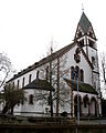
Parish Church of St. Matthias
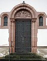
Side door of the parish church of St. Matthias
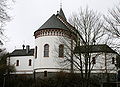
Apse side of St. Matthias Church, seen from the southeast

Old linden tree on the portal of the parish church of St. Matthias

Rectory

Evangelical Church, portal

Evangelical Church, side view

Courtyard house, seen from the southwest

primary school

Former syringe house

Kulturscheune (center) and part of the rear of Bahnhofstrasse 23

Bahnhofstrasse 12

Bahnhofstrasse 21

Carving on Bahnhofstrasse 21

Bahnhofstrasse 26

Gemündener Strasse 4/6

Heepengasse 5

In the monastery 7

In the monastery 11

Westring 16


Catholic parish church of St. Matthias and rectory
The Catholic St. Matthias Church was completed in 1897 in neo-Romanesque style based on designs by the Frankfurt architect Joseph Mack . Originally, the new building, which was very large for the size of the place at the time, was supposed to serve as a common church with Wilsenroth, but this was never realized because of a dispute between the two communities. The structure and an 800 year old linden tree stand on an elevation. A chapel has been located here since the 13th century at the latest. The immediate predecessor building was built around 1650. In 1931 the building received its current pulpit.
The building is closely based on the classic shape of the basilica . This is mainly expressed in the fact that the aisles and the transept are clearly subordinate to the main nave in terms of their height and area. The interior of today's church includes a Romanesque flat ceiling and columns with capitals as well as wall paintings and nave windows from Art Nouveau . To underpin the hillside location towards the Dermesbach valley, the church was underlain with an externally accessible crypt. This shows unplastered masonry in the typical dark basalt stone of the region.
The parsonage and the church form a listed ensemble. It was built in 1905 as a villa-like structure. It is likely that several parts of the building were originally designed as half-timbered structures, as can still be seen today in the dwelling on the entrance side. However, these and presumably other equipment details were lost during later modifications. The entrance and the associated vestibule, both of which show clover-leaf outlines, are further prominent building details. The entire ensemble at the church includes three baroque grave crosses .
Protestant church
In the strongly Catholic village, this church was built in 1905/06 for a Protestant diaspora congregation of around 50 people. The church blended into Mainzer Straße (now Bundesstraße 54 ), which was only recently built on and which comes from the south towards the old village center. The neo-baroque building was built from regional quarry stone that was left unplastered. The building mixes elements of Heimatstil and Art Nouveau , especially in the carving of the vestibule. The flat barrel vault is made of wood and still bears the painting from the time of construction. The architect was probably Ludwig Hofmann , state master builder of the Evangelical Church in Nassau . Address: Mainzer Straße 19
Courtyard house
The courtyard house on the northern edge of the village is a former Fronhof, which a Junker Oswald von Obentraut and his wife from the regionally influential House of Reifenberg had built in its current form from 1556 to 1577 . Oswald was an uncle of the rider general Hans Michael Elias von Obentraut . The western wing was already in place at the time of the expansion. Its year of construction is unknown. Shortly after the expansion, ownership of the facility began to change several times. In 1757 it was sold to the House of Nassau-Orange , where it remained as a leased domain until 1822.
The building was raised like a castle over the old village center. The western part is a massive stone building, the younger eastern part, which was built at right angles, has a stone base and a half-timbered structure. In the 16th century, the building got its present form with the erection of the stair tower with a spiral staircase and a curved hood. The half-timbering of the younger part is kept quite simple, with the firebacks of the southwest gable as a defining exception. The northwest wall shows a conspicuous lavatory bay on the upper floor . In 1728 a two-storey bay window was added to the southwest gable, which came from a house built in 1614. Address: Mainzer Straße 36
primary school
1860 the building in late classicist style from the typical local basalt stone-built, contrasting with the robe light sandstone. The straight lintels are only varied in the central axis with round arches above the also round arched double portal. The retaining wall facing the street with its wide staircase also adds to the architectural effect. Address: Bahnhofstrasse 20
Former syringe house
This half-timbered house, dated 1763, was built as a single house with a barn entrance in the middle of the street front. Overall, the framework is very simple and straightforward. In the right part of the house as seen from the street, the former residential zone, there is also jewelery in the form of nested S-shaped and arched struts. The roof and the sides facing away from the street are no longer in their original condition. For later use as a syringe house, another driveway was created on the left edge of the eaves side. After 2000, this driveway and the central barn entrance were converted into shop windows for use in shops. The non-historical roof was provided with dormers on this occasion and the window arrangement on the ground floor was slightly changed, which reduced some of the chassis malfunctions that had previously occurred. Address: Bahnhofstrasse 23
Culture barn
This Streckhof consisted of a small house, which was attached to a voluminous barn on the right. In 2005 the house was demolished and in the following years the barn was converted into a meeting and event location with a small exhibition on the history of the local area. The framework shows simple forms with a few cross braces and a three-zone structure. Address: Kirchstrasse 1
Bahnhofstrasse 12
The outer walls of the upper floor and gable of this house are still made of half-timbered and are therefore under monument protection. The remaining parts of the building have now been replaced by massive masonry. On the eaves side, the two different half-timbered zones are clearly visible, which were created between 1700 and 1750 in quick succession. The right section is more elaborate with nested round struts than the left half-timbered zone. At the time of construction, the building completed the development of today's Bahnhofstrasse towards the outskirts.
Bahnhofstrasse 21
This half-timbered building was built in 1717, as evidenced by a new date in the entablature. Today the building consists of three half-timbered zones and a recent extension. Outstanding building decorations are the grooved round struts on the upper floor, man forms in the half-timbered structure, the profiled threshold between the first and upper floors and the carvings on the Franconian bay window. These jugs, mugs and loaves of bread as well as a sun, which indicates a former bakery.
Bahnhofstrasse 26
This two-zone half-timbered house, facing away from the street, also contained stables, shows the typical, very simple structures of the late 18th century with some male shapes . By relocating the entrance to the gable side, the original state of the ground floor was changed significantly. It is likely to have been one of the first houses to be built on today's upper Bahnhofstrasse.
Gemündener Strasse 2/6
The two houses are built next to each other on the gable side and form a single eaves side. At number 6 you can see the half-timbered structure with man forms and St. Andrew's crosses as well as carvings on the frames and corner posts, which presumably continues under the plaster at number 2. The building closes off the upper Bahnhofstrasse with its comparatively well-preserved historical development and is highlighted on the “Alten Schmiedeplatz” at the junction of the Landstrasse in the direction of Gemünden.
Heepengasse 5
The three-zone house of this small property, laid out as a Streckhof, was built in the 18th century with rich half-timbered decorations. The beams are wide, the struts as man forms, St. Andrew's crosses or grooved S-woods. The entrance that was created later on the left, the former stable and workshop area, disturbs the otherwise exemplary specimen of the Westerwald half-timbering. Additional carvings are only made in the middle zone of the building, in which there is also a Franconian bay window. The front door, including the handle, lock and flanking carved columns, seems to date from the construction period. However, the lintel was apparently changed and an inscription panel was removed. In terms of interior design, the room layout, which has hardly changed, and a Cologne ceiling are worth mentioning, from which at least the consoles come from the construction period. The barn on the right with simple half-timbering probably dates from the end of the 18th century.
In the monastery 7
The eaves wall on the street side of the half-timbered upper floor of this largely changed residential building has been preserved. The two-zone, otherwise simple construction shows carvings on the frame and threshold as well as restrained jewelry with simple St. Andrew's cross and nested S-struts below the window.
In the monastery 11
This elongated, very simple half-timbered building was part of the so-called "Westerburger Hof", which was owned by the Seligenstadt Benedictine monastery in the Middle Ages . The building dates from the 16th or 17th century.
Westring 16
Langendernbach's youngest listed building was built on a ring road that was then around the old village center. It shows elements of home and country style. Valuable elements are the half-timbering of the attic, the distinctive quarry stone plinth and the wooden portico above the entrance.
Natural monument
.jpg)
- Langendernbacher Kirchlinde
It is on Bahnhofstrasse in the churchyard of the village church of St. Matthias. As a natural monument designated (ND 3533003 1) and in the prominent list and old tree specimens registered Sommerlinde one of the oldest trees in Germany. According to various sources, their age is given as 500 to over 800 years. In the originally huge trunk of the imposing tree veteran, there is no longer any wood, it is completely hollow. The remaining stem fragments now look like three individual stems. Its total circumference, measured in 2017, is 11.75 m. Today's relatively low crown is formed from much younger branches and new shoots that have grown back on the old trunk parts.
Economy and Infrastructure
Langendernbach is the seat of the Stephan Schmidt Group , one of the world's largest manufacturers of special clays.
The Langendernbach volunteer fire brigade (founded in 1897, with a youth fire brigade since March 12, 1971 ) provides fire protection and general help.
literature
- Josef Hörle: Langendernbach in good and bad days. History of a Westerwald village community. With the collaboration of Walter Heep, Dean Schneider and J. Graulich. Langendernbach 1957.
- Hanna Wippermann: Langendernbach between 1945 and 2000 , Dornburg 2000.
- Literature on Langendernbach in the Hessian Bibliography
Web links
- District Langendernbach on the website of the municipality of Dornburg.
- Langendernbach, Limburg-Weilburg district. Historical local dictionary for Hessen. In: Landesgeschichtliches Informationssystem Hessen (LAGIS).
Individual evidence
- ↑ a b c d Langendernbach, Limburg-Weilburg district. Historical local dictionary for Hessen. (As of June 8, 2018). In: Landesgeschichtliches Informationssystem Hessen (LAGIS).
- ↑ Numbers and facts . In: Internet presence. Dornburg municipality, accessed on April 24, 2020 .
- ↑ Law on the reorganization of the Limburg district and the Oberlahn district. (GVBl. II 330-25) of March 12, 1974 . In: The Hessian Minister of the Interior (ed.): Law and Ordinance Gazette for the State of Hesse . 1974 No. 5 , p. 101 , § 8 ( online at the information system of the Hessian state parliament [PDF; 809 kB ]).
- ^ Federal Statistical Office (ed.): Historical municipality directory for the Federal Republic of Germany. Name, border and key number changes in municipalities, counties and administrative districts from May 27, 1970 to December 31, 1982 . W. Kohlhammer GmbH, Stuttgart and Mainz 1983, ISBN 3-17-003263-1 , p. 369 .
- ^ Michael Rademacher: German administrative history from the unification of the empire in 1871 to the reunification in 1990. State of Hesse. (Online material for the dissertation, Osnabrück 2006).
- ↑ Wippermann 2000, p. 145.
- ↑ “ Map of Germany The oldest trees” in the German Tree Archives
- ↑ "Kirchlinde in Langendernbach" in the tree register at www.baumkunde.de
- ↑ "Summer linden tree 'Kirchlinde' on the grounds of the church in Langendernbach" in Monumental Trees at monumentaltrees.com
.png)