
Wilsenroth
|
Wilsenroth
Dornburg municipality
Coordinates: 50 ° 31 ′ 41 ″ N , 8 ° 1 ′ 9 ″ E
|
|
|---|---|
| Height : | 336 (280-350) m above sea level NHN |
| Area : | 2.71 km² |
| Residents : | 1344 (Dec. 31, 2019) |
| Population density : | 496 inhabitants / km² |
| Incorporation : | 1st February 1971 |
| Postal code : | 65599 |
| Area code : | 06436 |
 Aerial view of the place from the north-west. At the top right of the picture the plateau of the Dornburg (with the remains of the oppidium ), in the middle the former quarry.
|
|
Wilsenroth is a district of the Dornburg community in the Limburg-Weilburg district in Central Hesse .
Geographical location
Wilsenroth is located on the eastern slope of the Westerwald , naturally in the Oberwesterwälder Kuppenland, around 16 kilometers north of the district town of Limburg an der Lahn . The Limburg – Altenkirchen railway runs along the northeastern edge of the village and has a stop at the village, while the Elbbach flows a little further northeast .
The comparatively small Wilsenrother district borders on Langendernbach in the northeast and Frickhofen in the south , both of which are Dornburg districts. In the northwest, the district border is also the state border to Rhineland-Palatinate . There the area of the municipality of Berzhahn joins.
The place lies on the northeast slope of the basalt massif from Dornburg and Blasiusberg. On both there are interesting archaeological and cultural evidence of the past, remains of the Dornburg oppidium and the Blasiusberg Chapel . The built-up location extends from 280 to 350 meters above sea level. The entire district traces this hillside location on a larger scale. The highest point is around 430 meters west of the village, the lowest northeast at 250 meters in the Elbbachtal .
In addition to the mixed forest to the west and south of the village and the agricultural area to the east, which is mainly used as grassland, a large, now disused basalt quarry south of Wilsenroth determines the image of the district.
history


Wilsenroth was mentioned for the first time in 879 in a deed of donation from the St. Severus Monastery in neighboring Gemünden. Possibly the place was created during the early medieval clearing period around 750, which is indicated by the ending -roth .
In the Middle Ages, the place was part of a judicial district, the center of which was the church on the nearby Blasiusberg. Ecclesiastically, the place was assigned to the parish of Gemünden until 1669. In addition, little is known about Wilsenroth's medieval history. Document mentions only occur more frequently when the village passed from the ownership of the monastery to the Leiningen-Westerburg house during the Reformation in the 1560s , which already had bailiff rights over the place. In the course of the decline of Leiningen Westerburg, Wilsenroth fell to the Principality of Nassau-Hadamar in 1667 . In 1669 it changed from the parish of Gemünden to the parish of Blasiusberg . In 1742 the place burned down almost completely.
The settlement of Obertraut was located southwest of the village in the Middle Ages , but at an unknown time between 1287 and 1612 it fell into desolation and the majority of its inhabitants moved to Wilsenroth. A first chapel was probably built in Wilsenroth around 1650, but the year of its construction can only be determined precisely for the subsequent building, the Bartholomäus chapel, and later also the Anna chapel, as 1779. A parish church was built from 1900 to 1902 and the old chapel was demolished in 1903. In 1928 Wilsenroth became a parish vicarie and construction of the rectory began. In 1950 the Vicarie was raised to an independent parish. From 1960 to 1961 the dilapidated old church was torn down except for the tower and the new building was erected, which is under the patronage of St. Bartholomew .
In 1761 school lessons were held in Wilsenroth for the first time in winter. Before that, the children had to run to the parish school in Frickhofen. In 1810 the French administration hired a full-time schoolmaster for the first time and rented an empty house as a school. The new schoolhouse was completed in 1860 and became the mayor's office in 1950 and is now the village museum. Another school building was built in 1899 and has since been demolished. The current elementary school was built in 1937. In 1817 a community baking house was built, which was expanded in 1891 and served as a school and the official seat of the community administration. The building was demolished in 1961. In 1903 there were water pipes in the village for the first time and in 1923 electricity. In 1935 a new school building was built. A kindergarten was built in 1974 and a multi-purpose hall in 1972.
In 1903 Wilsenroth received water pipes, in 1920 electricity.
On February 1, 1971 Wilsenroth joined the new municipality of Dornburg as part of the regional reform in Hesse .
Territorial history and administration
The following list gives an overview of the territories in which Wilsenroth was located and the administrative units to which it was subordinate:
- before 1711: Holy Roman Empire , Principality of Nassau-Hadamar , Mengerskirchen Office
- 1717–1743: Holy Roman Empire, Principality of Nassau-Dillenburg , Mengerskirchen Office
- 1743–1806: Holy Roman Empire, Counts of Nassau-Diez as part of the Principality of Nassau-Orange , Amt Mengerskirchen
- 1806–1813: Grand Duchy of Berg , Department of Sieg , Canton Hadamar
- 1813–1815: Principality of Nassau-Orange , Mengerskirchen Office
- from 1816: German Confederation , Duchy of Nassau , Hadamar Office
- from 1849: German Confederation, Duchy of Nassau, Hadamar District Office
- from 1854: German Confederation, Duchy of Nassau, Hadamar Office
- from 1867: North German Confederation , Kingdom of Prussia , Province of Hessen-Nassau , Administrative Region of Wiesbaden , Oberlahnkreis
- from 1871: German Empire , Kingdom of Prussia, Province of Hessen-Nassau, administrative district of Wiesbaden, Oberlahnkreis
- from 1886: German Empire, Kingdom of Prussia, Province of Hesse-Nassau, District of Wiesbaden, District of Limburg
- from 1918: German Empire, Free State of Prussia , Province of Hessen-Nassau, Administrative Region of Wiesbaden, Oberlahnkreis
- from 1944: German Empire, Free State of Prussia, Nassau Province , Limburg District
- from 1945: American zone of occupation , Greater Hesse , Wiesbaden district, Limburg district
- from 1949: Federal Republic of Germany , State of Hesse , Wiesbaden district, Limburg district
- from 1968: Federal Republic of Germany, State of Hesse, administrative district Darmstadt , district Limburg
- on February 1, 1971 Wilsenroth was incorporated as a district of the newly formed Dornburg municipality.
- from 1974: Federal Republic of Germany, State of Hesse, administrative district Darmstadt, district Limburg-Weilburg
- from 1981: Federal Republic of Germany, State of Hesse, Gießen district, Limburg-Weilburg district
Economic history
For centuries in Wilsenroth only poor agriculture was possible because of the poor soil conditions. For the same reason, a large part of the area was covered by forest, because clearing was not worthwhile. Until the late 19th century, during the period of pauperism , numerous residents had to earn their living as migrant workers, especially brick makers, or peddlers across Europe, similar to other places in the Westerwald. In addition, during this time various administrative decisions made the area smaller, which led to the loss of considerable forest areas in the municipality's property.
A significant upswing began in 1886 with the commissioning of the train station in Wilsenroth and the opening of several basalt quarries in the following year. The quarries not only created jobs, but also benefited the community treasury through lease and tax income. In 1989, mining in the last basalt quarry in Wilsenroth was stopped. In the third quarter of the 20th century, lively tourism established itself in the place, which reached its highest value in 1965 with almost 22,000 overnight stays. In 1967 Wilsenroth was recognized as a resort and in 1978 as a climatic health resort . At the end of the 1970s, however, tourism only played a very minor role.
population
Population development
The oldest population survey dates back to 1506 and shows 60 Wilsenrother. Around 1610 there were 130 inhabitants. The plague and the Thirty Years War reduced the number to 39 by 1645. In 1809 the place had 306 inhabitants. In the First World War, 31 Wilsenrother fell, in the Second 52. After the Second World War, around 200 displaced persons settled in the village.
| Wilsenroth: Population from 1834 to 1970 | ||||
|---|---|---|---|---|
| year | Residents | |||
| 1834 | 364 | |||
| 1840 | 372 | |||
| 1846 | 380 | |||
| 1852 | 383 | |||
| 1858 | 398 | |||
| 1864 | 439 | |||
| 1871 | 414 | |||
| 1875 | 474 | |||
| 1885 | 429 | |||
| 1895 | 493 | |||
| 1905 | 605 | |||
| 1910 | 682 | |||
| 1925 | 833 | |||
| 1939 | 959 | |||
| 1946 | 1,180 | |||
| 1950 | 1,165 | |||
| 1956 | 1,077 | |||
| 1961 | 1,123 | |||
| 1967 | 1,270 | |||
| 1970 | 1,301 | |||
| Data source: Historical municipality register for Hesse: The population of the municipalities from 1834 to 1967. Wiesbaden: Hessisches Statistisches Landesamt, 1968. Other sources: | ||||
Religious affiliation
Source: Historical local dictionary
| • 1885: | 5 Protestant (= 1.17%) and 424 Catholic (= 98.83%) residents |
| • 1961: | 32 Protestant (= 2.85%) and 1090 Catholic (= 97.06%) residents |
Culture and sights
The place does not have an official coat of arms, but traditionally the rooster, called "Gickel" in the local Westerwald dialect, is regarded as an unofficial heraldic animal. The rooster is shown on the town flag created in 2009 and is also placed as a figure at the top of the fair tree .
societies
Wilsenroth has founded in 1928 Volunteer Fire Wilsenroth (since 1932 with marching band and since 1970 with youth fire brigade ), local associations of Catholic workforce, Catholic Women's Community, Catholic youth and VdK, the church choir "Cecilia," the male voice choir "Frohsinn", a museum - and cultural association, the music association “Dornburg-Musikanten”, a beautification, a sports and a gymnastics club .
Buildings

Old church tower, today integrated into the new church building

railway station
Bahnhofstrasse 30

Bahnhofstrasse 79
Former rectory


St. Bartholomew Church
Only the tower of the church built in 1902 is a listed building. It is a square tower built from regional basalt stones with a conspicuously high pointed helmet. Corner turrets and wich houses also adorn the roof. Address: Kirchstrasse 4
railway station
This station on the Limburg – Altenkirchen railway line was completed in 1886. The facade is characterized by the bricked, relatively small-format basalt stones and contrasting bricks. The knee of the north wing and the small cargo warehouse attached to the south are half-timbered. A flat roof building was later built in front of the gable end facing the track, which houses the mechanical signal box. The station is still used today for rail operations and has been privately owned since 2003. Address: Bahnhofstrasse 83
Bahnhofstrasse 30
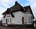
At the time of its construction in 1907/08, the building was outside of the local area. The villa-like house in the country house style is surrounded by a park-like garden. The structure is shaped by a loggia , a portico , various bay windows and the low roof. The facade is very heterogeneous with exposed and plastered basalt masonry, half-timbered sections and wood paneling. Colored Art Nouveau windows are still partially preserved.
Bahnhofstrasse 79
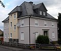
The large-format building was built in 1907 as an inn outside the old town center, directly opposite the train station. In addition to the building material, which is rather unusual for the region, clinker, the mansard roof , the dwelling above the hanging and shaped stones highlight the building in the townscape. Its use as a restaurant ended in May 2016.
Former rectory
The villa-like, square building was built in 1910 as a rectory in an exposed location right next to the church. The hipped roof , a dwarf house, a risalit on the south-west facade and the portal with a travertine border form architectural features. The window structure that exists today and the shutters are from the construction period. Address: Schulstrasse 7
Infrastructure
The Wilsenroth volunteer fire brigade (founded in 1928, with a youth fire brigade since January 1, 1970) provides fire protection and general help.
Web links
- Wilsenroth district on the Dornburg community website.
- Wilsenroth, Limburg-Weilburg district. Historical local dictionary for Hessen. In: Landesgeschichtliches Informationssystem Hessen (LAGIS).
- Literature on Wilsenroth in the Hessian Bibliography
Individual evidence
- ↑ a b c d Wilsenroth, Limburg-Weilburg district. Historical local dictionary for Hessen. (As of June 8, 2018). In: Landesgeschichtliches Informationssystem Hessen (LAGIS).
- ↑ Numbers and facts . In: Internet presence. Dornburg municipality, accessed on April 24, 2020 .
- ↑ Forests and people through the ages
- ^ Municipal reform: mergers and integration of municipalities from January 20, 1971 . In: The Hessian Minister of the Interior (ed.): State Gazette for the State of Hesse. 1971 No. 6 , p. 248 , para. 13 ( online at the information system of the Hessian state parliament [PDF; 6.2 MB ]).
- ^ Federal Statistical Office (ed.): Historical municipality directory for the Federal Republic of Germany. Name, border and key number changes in municipalities, counties and administrative districts from May 27, 1970 to December 31, 1982 . W. Kohlhammer GmbH, Stuttgart and Mainz 1983, ISBN 3-17-003263-1 , p. 369 .
- ^ Michael Rademacher: German administrative history from the unification of the empire in 1871 to the reunification in 1990. State of Hesse. (Online material for the dissertation, Osnabrück 2006).
.png)