
Biebertal
| coat of arms | Germany map | |
|---|---|---|

|
Coordinates: 50 ° 38 ' N , 8 ° 35' E |
|
| Basic data | ||
| State : | Hesse | |
| Administrative region : | to water | |
| County : | to water | |
| Height : | 226 m above sea level NHN | |
| Area : | 43.94 km 2 | |
| Residents: | 10,048 (Dec. 31, 2019) | |
| Population density : | 229 inhabitants per km 2 | |
| Postal code : | 35444 | |
| Primaries : | 06409, 06446 | |
| License plate : | GI | |
| Community key : | 06 5 31 002 | |
| LOCODE : | DE BB9 | |
| Address of the municipal administration: |
Mühlbergstrasse 9 35444 Biebertal |
|
| Website : | ||
| Mayoress : | Patricia Ortmann ( independent ) | |
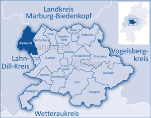
| Location of the municipality of Biebertal in the district of Gießen | ||
  |
||

Biebertal is a municipality in the central Hessian district of Gießen . It is named after the beaver that flows through the municipality from north-northwest to south-southeast.
geography
Biebertal lies around the landmark, the almost 500 m high Dünsberg and on the western edge of one of the largest contiguous forest areas in Hesse, the Krofdorfer Forest (also Prussian Forest ), both parts of the Krofdorf-Königsberger Forest natural area .
The community is located in the Gleiberger Land on the foothills of the Gladenbacher Bergland into the Giessen basin . The municipal area almost coincides with the catchment area of the Lahn tributary Bieber , which with its source rivers Strupbach and Dünsbergbach as well as its tributary Kehlbach provides the valleys where almost all districts are located. Only Krumbach drains via the stream of the same name , the Vers and finally the salt flats to the Lahn, while Frankenbach lies directly between the sources of Dünsbergbach and Frankenbach (also to the Vers) and Königsberg between those of Strupbach and Schwalbenbach (independent Lahn tributary).
Neighboring communities
Biebertal borders in the north on the communities Bischoffen ( Lahn-Dill-Kreis ) and Lohra ( district Marburg-Biedenkopf ), in the east on the community Wettenberg , in the south on the community Heuchelheim and the community Lahnau (Lahn-Dill-Kreis), im To the southwest to the city of Wetzlar (Lahn-Dill district), and to the west to the community of Hohenahr (Lahn-Dill district). Biebertal forms the Gleiberger Land with Wettenberg, Lahnau and Heuchelheim .
Community structure
Biebertal is a large municipality consisting of the following places: Fellingshausen , Frankenbach , Königsberg , Krumbach , Rodheim-Bieber and Vetzberg .
history

The Celts already settled on the strategically good Dünsberg, which is proven by numerous excavations. "Biber" was first mentioned in AD 775: a Meggenheim then donated property to Biberaha (Bieber) to the Fulda monastery . The next mentions were 1300-1454 under "Biberaha". It was not until 1680 that it was first called "uff der Bieber". The population was made up of day laborers and a few farmers . There were seven mills on the upper reaches of the Bieberbach , around which only a few houses were grouped until the middle of the 19th century. The population was 190 in 1837.
The development of the ore mines (see Friedberg mine and list of mines in the Lahn-Dill area ) and the settlement of the cigar factory in the second half of the 19th century brought Bieber a boom. A kind of "industrial area" was created in Kehlbachstrasse, a hammer forge was mentioned in 1422. The development continued: in 1620/1622 the mining and burning of lime is mentioned, lime was mined industrially from 1941 onwards.
As a result, the railway line for the "Bieberlies" (see Biebertalbahn ) was built in 1898 . An ore loading point for the railway was near the Ida tunnel dug in 1890 in Baumgarten, where the machine house of the former Eleanor mine can still be seen today. In 1906 a water pipe was laid (with 70 Italian guest workers), electricity came in 1914, and a bypass road in 1973 .
The district of Bieber was previously divided into three parts. The area belonged to Königsberg, Fellingshausen and Rodheim. Bieber's attempts to become its own municipality failed as early as 1862 when the mayors Wagner (Rodheim) and Gerlach (Fellingshausen) rejected the creation of the Bieber district. Since April 1, 1933, Bieber belonged to Rodheim.
Church building
As part of the regional reform in Hesse , the municipality of Biebertal was founded on December 1, 1970 through the voluntary merger of the municipalities of Fellingshausen , Königsberg , Krumbach , Rodheim-Bieber and Vetzberg . The seat of the municipal administration was Rodheim-Bieber. On January 1, 1977, the previously independent municipality of Frankenbach was incorporated into Biebertal by state law . Local districts with local advisory councils and local councilors were set up for all formerly independent communities .
politics
Community representation
The local elections on March 6, 2016 produced the following results, compared to previous local elections:
| Parties and constituencies |
% 2016 |
Seats 2016 |
% 2011 |
Seats 2011 |
% 2006 |
Seats 2006 |
% 2001 |
Seats 2001 |
||
|---|---|---|---|---|---|---|---|---|---|---|
| SPD | Social Democratic Party of Germany | 27.7 | 9 | 35.8 | 11 | 38.0 | 12 | 45.4 | 17th | |
| FWG | Free voter community Biebertal | 42.0 | 13 | 29.9 | 9 | 34.4 | 11 | 23.7 | 9 | |
| GREEN | Alliance 90 / The Greens | 13.4 | 4th | 15.8 | 5 | 6.7 | 2 | 6.7 | 2 | |
| CDU | Christian Democratic Union of Germany | 17.0 | 5 | 15.6 | 5 | 20.9 | 6th | 24.2 | 9 | |
| FDP | Free Democratic Party | - | - | 2.9 | 1 | - | - | - | - | |
| total | 100 | 31 | 100 | 31 | 100 | 31 | 100 | 37 | ||
| Turnout in percent | 51.7 | 49.6 | 47.1 | 56.2 | ||||||
Parish council
The community board in Biebertal consists of seven councilors and the mayor .
Local councils
The individual districts are each represented by a local advisory board. The local councils Fellingshausen, Frankenbach, Königsberg, Krumbach and Vetzberg have five members, the local council Rodheim-Bieber seven.
mayor
The non-party candidate Thomas Bender was elected mayor in the runoff election on September 25, 2005 with 53.1 percent of the vote. The turnout was 64.9 percent. In the mayoral election on September 4, 2011, Thomas Bender was re-elected with 66.5 percent of the vote in the first ballot, his challenger Ute Koch from the SPD received 33.5 percent of the vote, and the turnout was 51.8 percent. On September 24, 2017, the non-party candidate and incumbent Thomas Bender was no longer confirmed in his office. Patricia Ortmann (independent) and Michael Borke (SPD) were able to prevail. In the runoff election on October 15, 2017, Patricia Ortmann was elected mayor with 63.6% of the vote.
Parties
From 1994 to 1997, the FWG and the CDU had the majority in the municipal council. From 1997 to 2001 the majority in the municipal council was made up of the SPD and B90 / Greens. From 2001 to 2011, the SPD and CDU made up the majority in Biebertal, since 2011 the SPD and the FWG. Furthermore, Bündnis 90 / Die Grünen and the FDP are represented in the municipal council.
The former mayor of Biebertal, Helga Lopez (SPD), represented the constituency 172 Lahn-Dill (Lahn-Dill district as well as Biebertal and Wettenberg) as a direct candidate in the German Bundestag in the 16th legislative period .
coat of arms
The coat of arms was approved on February 20, 1974 by the Hessian Ministry of the Interior .
Blazon : “In a split field in front in black a red- tongued golden beaver turned to the left , behind in gold a red fox ; a golden crown set with blue stones in the red head of the shield . "
The crown as Koenigsberg's coat of arms appeared in the seal of the then "civitas Regiomontana" in the 16th century. The fox was chosen as the coat of arms symbol for the municipality of Fellingshausen in 1969 because its inhabitants were traditionally called red foxes or red heads. The beaver was in 1968 as "talking" , i. H. Symbol referring to the place name has been accepted by the community of Rodheim-Bieber . In the new coat of arms he also indicates the name of the newly formed community.
The coat of arms was designed by the heraldist Heinz Ritt .
flag
The flag was approved by the Hessian Ministry of the Interior on October 22, 1980.
Flag description: "Between two narrow red side stripes a wide yellow central strip, in the upper half covered with the municipal coat of arms."
Community partnerships
Biebertal maintains partnerships with:
- Sarrians in France since 1969
- Denbigh in Wales since 1991
- Eibenstock in the Ore Mountains in Saxony since 1991
Culture and sights
Attractions
- Vetzberg castle ruins
- Dünsberg (Celtic oppidum )
- Museum KeltenKeller
- Gail'scher Park with villa
- Schmitte mill
- Local museums in Rodheim and Frankenbach
- Sternschanze (ski jumping facility from the Seven Years War)
Natural monuments
Economy and Infrastructure
education
- Elementary school Biebertal (Rodheim)
- Elementary school at the Keltentor (Fellingshausen)
- Georg Kerschensteiner School, special educational competence center for all support needs
- The Biebertal comprehensive school was merged with the Wettenberg comprehensive school to form the Gleiberger Land comprehensive school.
Established businesses
- Schmidt & Bender GmbH & Co. KG, a company specializing in the production and development of high-quality rifle scopes
- ORION erotic specialist shops GmbH & Co. KG , company which operates 140 erotic specialist shops in Germany and Europe
Personalities
Sons and daughters of the church
- Heinrich Andreas Walther (born December 21, 1696 in Koenigsberg , † November 5, 1748 in Frankfurt am Main ), Evangelical Lutheran theologian and pastor
- Johann Georg Wille (born November 5, 1715 at the Obermühle am Dünsberg near Gießen, † April 5, 1808 in Paris ), important engraver , knight of the Legion of Honor , court engraver of the Roman-German Emperor , the King of France and the Danish King
- Klaus W. Müller (born April 21, 1945 in Mühlhausen an der Enz), German Protestant theologian and missiologist, lives in Biebertal
literature
- Erco von Dietze: Archive Evangelical Church Community Königsberg 1578–1950. Finding aid. 1989
- Erco von Dietze: Archive of the Evangelical Church Community Krumbach and Frankenbach 1628–1959. Finding aid. 1989
- Erco von Dietze: Archive of the Evangelical Church Community Rodheim / Vetzberg with former branches Bieber and Fellingshausen 1539–1965. Finding aid. 1989
- Literature about Biebertal in the Hessian Bibliography
- Search for Biebertal in the archive portal D of the German Digital Library
Web links
- Internet presence of the municipality of Biebertal
- Biebertal, district of Giessen. Historical local dictionary for Hessen. In: Landesgeschichtliches Informationssystem Hessen (LAGIS).
- Information on the community of Biebertal. In: Hessisches Gemeindelexikon. HA Hessen Agentur GmbH , 2016.
Individual evidence
- ↑ Hessian State Statistical Office: Population status on December 31, 2019 (districts and urban districts as well as municipalities, population figures based on the 2011 census) ( help ).
- ^ Wetzlarer Neue Zeitung: Bieber is mentioned for the first time in 775 . July 1, 2006
- ↑ Amalgamation of the communities Fellingshausen, Königsberg, Krumbach, Rodheim-Bieber and Vetzberg in the district of Wetzlar to form the new community "Biebertal" on November 13, 1970 . In: The Hessian Minister of the Interior (ed.): State Gazette for the State of Hesse. 1970 No. 48 , p. 2254 , point 2253 ( online at the information system of the Hessian state parliament [PDF; 5,6 MB ]).
- ^ Federal Statistical Office (ed.): Historical municipality directory for the Federal Republic of Germany. Name, border and key number changes in municipalities, counties and administrative districts from May 27, 1970 to December 31, 1982 . W. Kohlhammer, Stuttgart / Mainz 1983, ISBN 3-17-003263-1 , p. 379 .
- ↑ Law on the restructuring of the Dill district, the districts of Gießen and Wetzlar and the city of Gießen (GVBl. II 330–28) of May 13, 1974 . In: The Hessian Minister of the Interior (ed.): Law and Ordinance Gazette for the State of Hesse . 1974 No. 17 , p. 237 ff ., § 16 ( online at the information system of the Hessian state parliament [PDF; 1,2 MB ]).
- ↑ K.-H. Gerstenmeier: Hessen. Municipalities and counties after the regional reform. A documentation. Melsungen 1977, p. 282. DNB 770396321
- ↑ Main statute of the municipality of Biebertal. (PDF; 22 kB) p. § 5 , accessed in February 2019 .
- ^ Result of the municipal election on March 6, 2016. Hessian State Statistical Office, accessed in April 2016 .
- ^ Hessian State Statistical Office: Result of the municipal elections on March 27, 2011
- ^ Hessian State Statistical Office: Result of the municipal elections on March 26, 2006
- ↑ Approval of a coat of arms of the municipality of Biebertal, district of Wetzlar from February 20, 1974 . In: The Hessian Minister of the Interior (ed.): State Gazette for the State of Hesse. 1974 No. 10 , p. 488 , point 353 ( online at the information system of the Hessian state parliament [PDF; 6.5 MB ]).
- ↑ Approval of a flag for the municipality of Biebertal, Wetzlar district from October 22, 1980 . In: The Hessian Minister of the Interior (ed.): State Gazette for the State of Hesse. 1980 No. 45 , p. 2090 , point 1233 ( online at the information system of the Hessian state parliament [PDF; 4.4 MB ]).
- ^ Biebertal community: schools ( memento from March 11, 2016 in the Internet Archive ) accessed on March 11, 2016
- ↑ Giessener Allgemeine from July 10th, 2009: When the school ends, its head also leaves

Allendorf (Lumda) | Biebertal | Buseck | Fernwald | Casting | Grünberg | Heuchelheim an der Lahn | Hung | Langgöns | Laubach | Lich | Linden | Lollar | Pohlheim | Rabenau | Reiskirchen | Staufenberg | Wettenberg