Bieberbach (Kauerbach)
| Bieberbach | ||
|
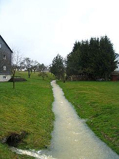
Bieberbach in Biebern |
||
| Data | ||
| Water code | DE : 254462 | |
| location |
Hunsrück
|
|
| River system | Rhine | |
| Drain over | Kauerbach → Simmerbach → Nahe → Rhine → North Sea | |
| source | in the Faas forest near Wüschheim 50 ° 0 ′ 58 ″ N , 7 ° 23 ′ 31 ″ E |
|
| Source height | approx. 490 m above sea level NN | |
| confluence | at Unzenberg train station with the Heinzenbach to the Kauerbach Coordinates: 49 ° 57 ′ 41 ″ N , 7 ° 27 ′ 17 ″ E 49 ° 57 ′ 41 ″ N , 7 ° 27 ′ 17 ″ E |
|
| Mouth height | 332 m above sea level NN | |
| Height difference | approx. 158 m | |
| Bottom slope | approx. 14 ‰ | |
| length | 11.1 km | |
| Catchment area | 19.091 km² | |
The Bieberbach is the approximately 11 km long, north and left source brook of the Kauerbach in Rhineland-Palatinate .
geography
The Bieberbach rises about 500 m above sea level in the Hunsrück in a wooded area ( Faas ) near Wüschheim and flows together with the Heinzenbach to the Kauerbach at Unzenberg station .
Flora and fauna
The Bieberbach flows through extensively used valley meadows, with willows and alders on the banks that are hardly used economically today. Gray herons and mallards are the most common water birds in the Bachtal.
Particularity by name
The valley of the upper reaches between Wüschheim and Nannhausen is called Biebertal .
The dialect term Bääsemdaal has been used for the Biebertal up to the present day .
