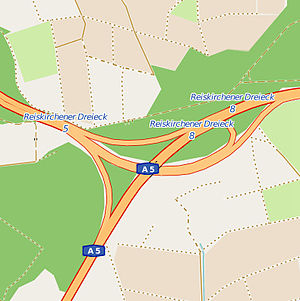
Reiskirchener triangle
| Reiskirchener triangle | |
|---|---|
|
|
|
| map | |
| location | |
| Country: | Germany |
| State : | Hesse |
| Coordinates: | 50 ° 36 '34 " N , 8 ° 49' 30" E |
| Height: | 270 m above sea level NN |
| Basic data | |
| Design type: | Left-hand trumpet |
| Bridges: | 1 (motorway) |
The Reiskirchener Dreieck is a motorway triangle in Hesse , which is located near Gießen . The federal motorway 480 ( Wetzlar - Reiskirchen ) ends here and merges into the federal motorway 5 ( Hattenbacher Dreieck - Frankfurt am Main - Basel ).
geography
The triangle is located in the municipality of Reiskirchen ( district of Gießen ), in the administrative district of Gießen . The surrounding towns and communities are Allendorf (Lumda) , Staufenberg and Rabenau . It is located in Central Hesse , about 10 km east of Gießen , about 90 km southwest of Kassel and about 55 km north of Frankfurt.
The Reiskirchener Dreieck is number 8 on the A 5 and number 5 on the A 480.
State of development
The A 5 has five lanes in this area, the A 480 has four lanes. All transitions are single-lane.
The triangle is designed as a left-hand trumpet.
Traffic volume
The motorway triangle is used by around 68,000 vehicles every day.
| From | To | Average daily traffic volume | Share of heavy goods traffic |
|---|---|---|---|
| AS Grünberg (A 5) | Reiskirchener triangle | 66,500 | 16.9% |
| Reiskirchener triangle | AS Reiskirchen (A 5) | 48,800 | 14.9% |
| Giessener Nordkreuz (A 480) | Reiskirchener triangle | 19,900 | 18.6% |
Individual evidence
- ^ Reiskirchen triangle. Motorway junctions and triangles in Germany, 2011, accessed on November 25, 2012 .
- ↑ Manual traffic census BAB 2015. BASt Statistics, 2015, accessed on August 18, 2017 . (PDF file)
