
Steineberg (Allgäu Alps)
| Steineberg | ||
|---|---|---|
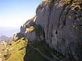
 Steineberg seen from the Bärenköpfle (1463 m) |
||
| height | 1683 m | |
| location | Bavaria , Germany | |
| Mountains | Pre-Alps west of the Iller , Allgäu Alps | |
| Dominance | 2.1 km → Stuiben | |
| Notch height | 83 m ↓ notch to Stuiben | |
| Coordinates | 47 ° 31 '39 " N , 10 ° 11' 31" E | |
|
||

The Steineberg ( 1683 m ) is a mountain in the Nagelfluh chain in the Allgäu Alps . The relatively easily accessible panoramic mountain above the Illertal is one of the most popular summit destinations in this region. The Steineberg is part of the international Nagelfluhkette Nature Park project . The gap height of the stone mountain is at least 83 meters, its dominance 2.1 kilometers, whereby the Stuiben is the reference mountain in each case.
Ascent
Route: Immenstadt - Steigbachtal - Mittagberg - Steineberg (duration approx. 3 hours): The summit can be reached via a short via ferrata (via ferrata closed since 2009 due to mudslides) and an approximately 17 m long ladder. However, these obstacles can also be avoided. The ascent can be shortened by using the midday train . The well-developed normal route leads from the mountain station of the Mittag (1419 m) to the rocky summit of the stone mountain. When it is wet, however, it is better to avoid the last section of the normal route along the northern edge of the summit plate. A steel ladder under the summit cross ( 1660 m ) enables direct ascent . The actual summit of the stone mountain is about 300 meters west of the steel ladder. The Graskuppe rises again about 20 meters above the summit cross.
The transition to Stuiben requires surefootedness and a head for heights . The path offers insights into the geological structure of the Nagelfluhkette. Shortly before the descent to Gund-Alpe, the path leads over a steep rock face secured by ropes. From the Gund-Alpe you can descend back to Immenstadt in around two hours.
From Gunzesried ( 889 m ) there is also a three-hour route across the Alpe Unterkirche to the Steineberg.
In the course of the Nagelfluh ridge hike with Hochgrat ( 1834 m ), Rindalphorn ( 1822 m ), Buralpkopf ( 1772 m ) and Stuiben ( 1749 m ), the Steineberg is crossed .
Mountain mass
A mountain mass takes place every year at the end of August at the summit cross of the Steineberg. It is organized by the Stoineberglar Trachtenverein and the parish council of Immenstadt-Bühl-Rauhenzell and musically accompanied by a delegation from the Akams band .
photos
Under the northern slopes of the summit plate

The summit plate. In the background the Grünten

View from the ridge path between Stuiben and Steineberg to the east

Ladder to the summit


literature
- Dieter Seibert: Allgäuer Alpen Alpin, alpine club guide . Munich, Bergverlag Rudolf Rother 2004. ISBN 3-7633-1126-2 .
Web links
Remarks
- ↑ Exact value not known, stated value is a minimum value (can be up to 19 meters higher). It was determined from the distance between the contour lines (20 meters in altitude ) on a topographic map ( scale 1: 25,000).
- ^ Mountain Masses 2011 of the Diocese of Augsburg .

Mittagberg | Bärenköpfle | Steineberg | Stuiben | Sedererstuiben | Buralp head | Gündleskopf | Beef alphorn | Hochgrat | Soul head | Hohenfluhalpkopf | Einguntkopf | Hawks | Hochhäderich