
Beef alphorn
| Beef alphorn | ||
|---|---|---|
 The Rindalphorn (Gündlesscharte location) |
||
| height | 1821 m above sea level NHN | |
| location | Bavaria , Germany | |
| Mountains | Allgäu pre-Alps west of the Iller , Allgäu Alps | |
| Dominance | 2.3 km → Hochgrat | |
| Notch height | 195 m ↓ Brunnenauscharte | |
| Coordinates | 47 ° 30 '19 " N , 10 ° 6' 28" E | |
|
||
| Normal way | Driveway from the valley station of the Hochgratbahn | |

The 1,821 meters above sea level high Rindalphorn is named after the neighboring peaks Hochgrat is the second highest peak of the Nagelfluhkette and is located on the district of Steibis , a municipality part of the market Oberstaufen in Oberallgäu , Schwaben in the state of Bavaria . The Rindalphorn is part of the international Nagelfluhkette Nature Park project .
geography
In contrast to the high ridge, which is very extensive in east-west direction, the summit of the Rindalphorn has an untypically slim shape for the Nagelfluhkette. This contrast to its western neighbors (Gelchenwanger Kopf and Hochgrat) gives the middle part of the chain its distinctive appearance, which is reflected, for example, in the logo of the Steibis district. The east ridge of the Rindalphorn is steep and the only larger part of the ridge of the Nagelfluhkette that no hiking trail leads over. The gap to the next mountain in the chain, the Gündleskopf, is the deepest between two neighboring mountains. To the north, the Rindalphorn falls abruptly from a pre-summit; Even the southern flank of the summit can only be overcome by climbing, so that the only hiking trail that branches off over the west ridge from the Nagelfluhgrat hiking trail to the summit cross is.
Alpine farms
The name for the Rindalphorn was derived from the Rindalpe in the north-facing basin of the Gündleskopf. The lower alpine hut still exists at 1244 m , the upper one at 1350 m has fallen into disrepair. On the north side are the Gündelalpe ( 1580 m ) and the Groppachalpe at a height of 1320 m . The Untergelchenwangalpe is on the southern slope at 1414 m .
Routes to the summit
The Rindalphorn is located east of the high ridge ( 1834 m ) and can be reached from there within 45 minutes.
Opportunities for ascent on the north side consist of the Ehrenschwanger Valley over the Rindalpe or over the 1624 m high Brunnenauscharte. In the valley you pass the Rochus chapel , consecrated to Rochus de Montpellier . The Renaissance altar comes from Oberstaufen Castle, which was demolished in 1807.
The climbs on the south side from the Bregenzerwald via Hittisau or the Gunzesrieder Säge are less known .
Gelchenwanger head

The Rindalphorn has an approximately 1,810 m high secondary peak on its west shoulder. This has a notch height of at least 30 m compared to the main summit, but is visually more distinct from it: On the one hand, the elongated shape of the secondary summit does not harmonize with the craggy and symmetrical main summit. On the other hand, the connecting ridge runs set back to the south, so that it appears deeper cut from the north (e.g. from Oberstaufen ). The secondary peak is named after the Gelchenwang Alpe on the common southern slope of the Rindalphorn and Hochgrat Gelchenwanger Kopf .
photos
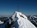
Summit with a summit cross

On the summit, view towards the Hochgrat

The eponymous Rindalpe taken from the summit

The summit photographed from the Rindalpe


literature
- Dieter Seibert: Alpine Club Guide Allgäu Alps and Ammergau Alps Alpine , 16th edition 2004, Bergverlag Rudolf Rother, Munich, ISBN 3-7633-1126-2
- Dumler Helmut: Summit destinations in the Allgäu Alps , GeraNova Bruckmann (1993), ISBN 978-3765426124
- Immler Josef: Walk with me through the Allgäu Alps , Verlag Brack, F (2003), ISBN 978-3-930323-23-4
Web links
Individual evidence
- ↑ a b from BayernAtlas: Rindalphorn (released on March 27, 2011) determined lower limit
Mittagberg | Bärenköpfle | Steineberg | Stuiben | Sedererstuiben | Buralp head | Gündleskopf | Beef alphorn | Hochgrat | Soul head | Hohenfluhalpkopf | Einguntkopf | Hawks | Hochhäderich