
High ridge chain
The high ridge chain , also known as the Rindalphorn layer ridge , is mainly located in the Oberallgäu district , Bavaria , but also reaches Vorarlberg in the southwest and reaches a maximum of 1834 m above sea level. NN high mountain range on the northern edge of the Allgäu Alps . It forms the middle and highest of the three parallel, south-westerly trending Nagelfluh chains of the Allgäu Nagelfluh layer ridges , named after the rock type Nagelfluh . On German soil it is almost congruent with the Nagelfluhkette nature reserve . The Nagelfluhkette Nature Park, founded on January 1, 2008, contains all three chains and part of the neighboring Alpine groups.

geography
Geographical location
The high ridge chain extends in the western part of the Allgäu Alps west of the Iller valley, in which the German cities of Sonthofen and Immenstadt are located. In between there is Blaichach , from where the chain stretches for around 20 km in a west-south-west direction to the Austrian Hittisau . The German-Austrian border runs on the saddle between Hohenfluhalpkopf and Hochhäderich (Hoher Häderich) over the mountain ridge.
The high ridge chain is one of the last higher elevations in the Alps , before the Allgäu foothills connect further north . In the north is the valley of the Weißach flowing westwards , in the southeast the group of horns rises beyond the valley of the Aubach flowing northeast . The B 19 leads past the Illertal in its section Sonthofen – Blaichach – Immenstadt .
mountains


The high ridge chain, the highest point of which is the high ridge ( 1834 m above sea level ), is composed of these mountains or peaks (from east to west):
| Mountain name (s) | country | Summit height | particularities |
|---|---|---|---|
| Mittagberg (noon) | D. | 1451 m | with double sesselbahn Mittagbahn |
| Bärenköpfle | D. | 1463 m | |
| Steineberg | D. | 1683 m | |
| Steinköpfle (1) | D. | 1669 m | independent tour destination |
| Stuiben | D. | 1749 m | |
| Sedererstuiben | D. | 1737 m | |
| Buralp head | D. | 1772 m | |
| Gündleskopf | D. | 1748 m | |
| Beef alphorn | D. | 1822 m | |
| Gelchenwanger head (2) | D. | 1805 m (3) | |
| High ridge | D. | 1834 m | Hochgratbahn , Staufner House |
| Soul head | D. | 1663 m | |
| Hohenfluhalpkopf | D / A | 1636 m | |
| Einguntkopf / Rohnehöhe | THERE | 1641 m | with the ski lift from Falkenhütte |
| Falcons (heads) | THERE | 1564 m (4) | with Falkenhütte (approx. 1450 m) |
| Hochhäderich (Hoher Häderich) | THERE | 1565 m | with double ski tow lift |


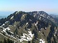
Western Nagelfluhkette from the north


Watershed
A section of the Rhine-Danube watershed , which is part of the main European watershed , runs over the Nagelfluh chain from Stuiben to the Hochgrat .
The water of the Weißach , which rises north of the mountain range, flows approximately westward into the Bregenzer Ach , which pours through Lake Constance or over the Rhine into the North Sea . In contrast, that of the Gunzesrieder Ach runs from its headwaters between the Nagelfluhkette and the Hörnergruppe to the northeast into the Iller , which strives over the Danube towards the Black Sea .
geology
One reason for the relative popularity of the Nagelfluhkette (s) is the geological structure of their mountains. It is composed of the conglomerate rock rocks together, the on concrete recalls: In a caked mass rounded rocks are enclosed, which come in the weathering process slowly to the surface and crumble. This is why Nagelfluhgestein is called "Herrgottsbeton" in the Allgäu.
The rock arose from mud, rubble and rubble, which was transported by primeval rivers during the formation of the Alps and deposited in a large pre-Alpine floodplain. Phases of alternating lime deposits led to the formation of layers of different binding qualities: layers with a sufficient lime content solidified to form horizontal Nagelfluh plates. The non-solidifiable sand and clay banks in between became less hard and less durable layers of sandstone and marl.
Subsequent folds pushed this layer system from the south onto the European continental plate and thus reared it towards the north. At the same time, the resulting summit edge eroded back to the south at the least strong points. Where even the deeper layers could not withstand the erosion pressure, steep breaks formed and below that the cirques typical of the north sides; the northern ridges remained at the points with more solid rock, particularly impressive on the Rindalphorn. Structure-forming in the north walls are the Nagelfluh plates, the sandstone and marl layers in between erode back early and leave a framework of impressively continuous Nagelfluh bands. It is above all the north sides of the Nagelfluhkette that today provide information about the stratified structure of the former alluvial land.
The south sides, on the other hand, are characterized by huge, inclined plate surfaces; some of the climbs on the south side consistently stay on a single slab. Usually the incline of this inclined plane is moderate at less than 30 °, so that forests or grass mats could form on it. In some places, however, the Nagelfluhplatten are steeper - on the Hochhädrich and on the Steineberg up to 50 °. Extensive vegetation can no longer establish itself in these walls and they remain bare. The erosion of the south-facing Nagelfluhplatten is less regular than on the other side of the ridge. Overhangs form on the edges of the mostly very extensive plates (above or on the side), as the soft layers underneath tend to erode.

Nagelfluhgestein at the summit of the Hochhädrich; the view is directed to the west
North sides of Seelekopf, Hohenfluhalpkopf and Einguntkopf; you can see that the rock bands also run continuously across the mountains
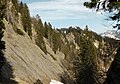
The steep south face below the east ridge of the Hochhädrich; in the background the falcon

Protruding plate edge in the south flank. Lush vegetation often sprouts in the hollows between the plates (left in the picture).


tourism
The Nagelfluhkette is flanked by lower mountain ridges in the north and south and offers excellent views in almost all directions.
Year-round mountain railways are available on the Mittagberg (Mittagbahn) and on the Hochgrat ( Hochgratbahn ) , each with a mountain restaurant.
hike
Hikes on the ridge path of the chain are among the most popular in the Oberallgäu district because of the view . Since all mountains can be climbed individually, there is a large variety of possible variations for a tightrope walk. Except for a few steps, there are no climbing difficulties to overcome. Many places, especially between stones mountain and Stuiben, and between hawks and Hochhädrich, but are exposed and require surefootedness and head for heights .
Shorter routes, for example, lead from the mountain station of the Mittagbahn over the Steineberg and Stuiben through the Steigbachtal back to Immenstadt. Another path is the Maximiliansweg , which leads in the area of the mountain range over the mountains Hochgrat , Rindalphorn and Buralpkopf .
Established medium-length tours are crossing the entire east chain from Hochgrat to midday ( Nagelfluh-ridge hike ) , which on this stage follows the European long-distance hiking trails E4 and E5 and crossing the west chain between Hochgrat and Falken (Luftiger Grat) .
The royal tour, the entire "Nagelfluhüberquerung" from noon mountain to the Hochhädrich is for athletic, very fit possible hikers in a single day (approx. 8: 30h including breaks). The Staufner House of the German Alpine Club is available as an accommodation hut .
Winter sports
In addition to the mountain railways, there are also ski lifts on the Eineguntkopf (from Falkenhütte) and on the Hochhädrich, each on the snow-sure north side.
Accordingly, there are slopes for skiers on the Mittagberg, Hochgrat, Eineguntkopf and Hochhädrich in Austria. Large parts of the Nagelfluh crossing are possible as winter hikes with snowshoes or with touring skis .

On the Stuiben east ridge

photos


View from Burgberg Castle over the village of Burgberg to the Hochgratkette with the mountains Stuiben , Mittagberg and the Immenstädter Horn on the eastern edge of the northern chain (from left to right)
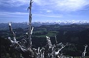
View of the Allgäu main ridge

Map with mountains of the Nagelfluhkette


literature
- B. Frey: Nagelfluhkette Nature Park. An illustrated book about nature, landscape, fauna, flora and people. 14 nature park communities in the Allgäu and Vorarlberg are presented . Edition Allgäu, Immenstadt 2009, ISBN 978-3-931951-41-2 , p. 224 .
Web links
- Technical information about the Nagelfluh am Hochgrat from the Bavarian State Office for the Environment
- Nagelfluhkette Nature Park
Coordinates: 47 ° 29 ′ 43 " N , 10 ° 4 ′ 43" E
Individual evidence
- ^ Hansjörg Dongus : Geographical land survey: The natural spatial units on sheet 187/193 Lindau / Oberstdorf. Federal Institute for Regional Studies, Bad Godesberg 1991. → Online map (PDF; 6.1 MB)
- ↑ Allgäu Alps: 50 hiking and snowshoe tours with tips on sledding Steinköpfle . Retrieved March 31, 2011
- ↑ K. Leitte: input head ( page no longer available , search in web archives ) Info: The link was automatically marked as defective. Please check the link according to the instructions and then remove this notice. , released on March 31, 2011

Mittagberg | Bärenköpfle | Steineberg | Stuiben | Sedererstuiben | Buralp head | Gündleskopf | Beef alphorn | Hochgrat | Soul head | Hohenfluhalpkopf | Einguntkopf | Hawks | Hochhäderich