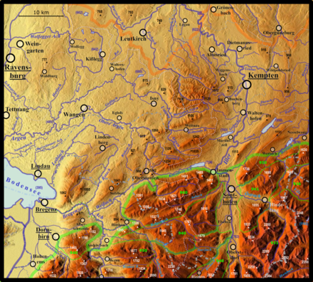
Allgäu Nagelfluh layer combs
Allgäuer Nagelfluh -schichtkämme is a mountain group and a natural area of the Allgäu Alps in the Bavarian district of Oberallgäu and in the Austrian Vorarlberg . It summarizes the three parallel, south-westerly trending Nagelfluhkette on the northern edge of the mountain range, which gave its name to the Nagelfluhkette Nature Park . The high ridge chain in the middle reaches 1834 m above sea level on the high ridge . NHN and at the Rindalphorn 1821 m . The northern chain is up to 1491 m high ( Immenstädter Horn on the eastern edge: 1489 m), the southern one at Siplinger Kopf up to 1746 m.
definition

In the handbook of the natural structure of Germany in 1953, the north-western part of the Alps touching Germany was mainly summarized in the main unit 020 Vorderer Bregenz Forest of the main unit group Swabian-Bavarian Pre-Alps , see natural structure of the Alps . This consisted on the one hand of the three Nagelfluhkette, on the other hand of the Pfänder (1062 m) together with the Hirschberg (1095 m) and the Sulzberg (1041 m) as well as two smaller, less than 1000 m reaching massifs, which run through Pfänder and Sulzberg from north to northwest be enclosed.
In 1991, Hansjörg Dongus, on behalf of the Federal Institute for Regional Studies , which had also published the manual, divided the associated region into finer units in the detailed breakdown of 1: 200,000 on page 187/193 Lindau / Oberstdorf . Like Klaus Hormann in 1978 on sheet 190/196 Salzburg , he did not summarize the alpine natural areas under the numbers 01 and 02, but under the 9th Dongus' or Hormann's system is more strictly based on the bedrock and also includes natural areas Units that are not simply connected .
Dongus found Pfänder, Sulzberg and the other two mountain ranges not alpine enough and therefore included them with the Nagelfluh and Molasse mountain ranges up to 1254 north of the Nagelfluh range up to Adelegg (up to 1129 m) in the new, non-alpine unit Nagelfluhhöhen and Senken between Lake Constance and Wertach , while the Nagelfluhkette with him formed an independent unit of the Alps.
The Bavarian State Office for the Environment (LfU) numbers the three shift combs under 020-01 to 020-03 and the Pfänder and Sulzberg under 020-00, and insofar sticks to the old main unit of the Vorderen Bregenz Forest.
Natural structure
The Allgäuer Nagelfluh layer combs are structured as follows:
-
(to 96 Swiss and Allgäu Nagelfluh layered lambs)
- 960 Allgäuer Nagelfluh layer combs
- 960.0 (= 020-03 at LfU) Prodel-Bunk-Layer Comb
- 960.00 Prodel -schichtkamm (at the Eckhalde (Muttner Höhe) 1491 m, at the Immenstädter Horn 1489 m)
- 960.01 berths layer comb (at the Fluh 1391 m)
- 960.02 Upper Weißach valley
- 960.1 (= 020-02 at LfU) Rindalphorn-layer ridge (= Hochgratkette ; on Hochgrat 1834 m, on Rindalphorn 1821 m)
- 960.2 (= 020-01 at LfU) Siplingerkopf layered comb (at Siplinger Kopf 1746 m)
- 960.3 Hittisberg (1328 m)
- 960.4 Stangstattkopf (1095 m)
- 960.0 (= 020-03 at LfU) Prodel-Bunk-Layer Comb
- 960 Allgäuer Nagelfluh layer combs
The units 960.3 and 960.4, which continue the Siplingerkamm to the southwest, are geological, but not independent as mountains. The Hittisberg sits on a northwest branch of the Feuerstätterkopf (1645 m, 940.01, Flyschalpen), the Stangstattkopf on a northwest spur of the Bezau vault group (950.5), which reaches 1877 m on the Winterstaude .
As a further subunit of the 96, Dongus sees the Gäbris layer ridges , which rise from the Gäbris (1247 m) to around 1660 m.
geology
See Hochgratkette # Geology , the explanations there also apply to the two outer ridges.
literature
-
Federal Institute for Regional Studies
- Emil Meynen , Josef Schmithüsen (Hrsg.): Handbook of the natural spatial structure of Germany . Federal Institute for Regional Studies, Remagen / Bad Godesberg 1953–1962 (9 deliveries in 8 books, updated map 1: 1,000,000 with main units 1960). (1st delivery 1953)
- Hansjörg Dongus : Geographical land survey: The natural spatial units on sheet 187/193 Lindau / Oberstdorf. Federal Institute for Regional Studies, Bad Godesberg 1991. → Online map (PDF; 6.1 MB)
Web links
- Natural areas of the main unit groups 01, 02 and 03 in the Bavaria Atlas of the Bavarian State Government - Northern Limestone High Alps and Swabian-Bavarian Pre-Alps as well as Subalpine Young Moraine Land ( notes )
- Landscape profile Allgäu layer ridges of the Federal Agency for Nature Conservation ( information ) - 140 km²
proof
- ^ Emil Meynen , Josef Schmithüsen (Ed.): Handbook of the natural spatial structure of Germany . Federal Institute for Regional Studies, Remagen / Bad Godesberg 1953–1962 (9 deliveries in 8 books, updated map 1: 1,000,000 with main units 1960).
- ^ Klaus Hormann: Geographical land survey: The natural space units on sheet 190/196 Salzburg. Federal Institute for Regional Studies, Bad Godesberg 1978. → Online map (PDF; 6.1 MB)
- ↑ a b c d Hansjörg Dongus : Geographical land survey: The natural spatial units on sheet 187/193 Lindau / Oberstdorf. Federal Institute for Regional Studies, Bad Godesberg 1991. → Online map (PDF; 6.1 MB)
- ↑ a b c d Natural areas of the main unit groups 01, 02 and 03 in the Bavarian Atlas of the Bavarian State Government - Northern Limestone High Alps and Swabian-Bavarian Pre-Alps and Subalpine Young Morain Land ( notes )
Coordinates: 47 ° 29 ′ 43 " N , 10 ° 4 ′ 43" E