
Winter shrub
| Winter shrub | ||
|---|---|---|
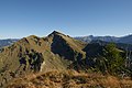
 Winter shrub seen from Sibratsgfälle |
||
| height | 1877 m above sea level A. | |
| location | Vorarlberg , Austria | |
| Mountains | Winter shrub ridge, Bregenz Forest Mountains | |
| Dominance | 6.6 km → Diedamskopf | |
| Notch height | 837 m ↓ west of Schönenbachvorsäß | |
| Coordinates | 47 ° 23 '58 " N , 9 ° 58' 48" E | |
|
||
| rock | Molasses | |

The Winterstaude is a 1877 meter high mountain in the Bregenz Forest in Austria . It is located south of Hittisau in the municipality of Egg (Vorarlberg) . The north side is partially accessible by mountain railways, and a ski area is operated there in winter.
Mountain ridge
The winter shrub is not isolated, but is the highest and central elevation of a mountain ridge ( Niedere-Kamm ) in a west-east direction from Andelsbuch . The ridge is bounded in the north and east by the river Subersach . To the south, this mountain range is separated by the Helbockstobel from the next ridge, which runs parallel from the Winterstaude onwards, with Hälekopf (1614 m), Luguntenkopf (1702 m, also Hinteregg ) and Sienspitze (1600 m). There are numerous alpine meadows on both the north and south slopes .
The main elevations in west-east direction are:
- Hintere Niedere (1711 m)
- Tristenkopf (1741 m)
- Stongerhöhe (around 1750 m)
- Winter shrub (1877 m)
- High Church (1747 m)
- Bullerschkopf (1761 m)
- Nägelekopf (1693 m)
The maximum straight line distance between these peaks is 5.5 kilometers. The notch height of the winter shrub is at least 837 meters, its dominance 6.6 kilometers, with the Diedamskopf being the reference mountain in each case.
Tours
The tours from the north side run all over a ridge whose coping surefootedness and head for heights required. The valley location is Großdorf , the starting point for the tours at the parking lot of the Schetteregg lifts (1070 m). The main summit can be reached in different ways, the walking time for these tours is around two to two and a half hours:
- direct ascent to Hasenstrick, a ridge saddle to the Stongerhöhe
- over the Tristenkopf
- over the Falzalpe
The ascent from the west can be done with the help of the Andelsbuch mountain railways and runs from the mountain station over the ridge path and takes about two and a half hours. If the mountain is climbed starting in Bezau , the long tour over the Stongeralpe is the only way up that does not lead over the ridge.
photos


North side

In the south flank
Lower ridge to the west

View of Lake Constance
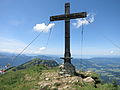
On the winter shrub
On the Tristenkopf

On the nail head

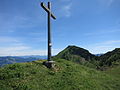
The Bullerschkopf; the summit cross is not exactly on the highest point


.JPG)


Web links
References and comments
- ↑ To the winter shrub . Retrieved March 15, 2011.
- ↑ Exact value not known, stated value is a minimum value (can be up to 19 meters higher). It was determined from the distance between the contour lines (20 meters in altitude ) on a topographic map ( scale 1: 25,000).
- ^ Federal Office for Metrology and Surveying Austria: Austrian Map online (Austrian map 1: 50,000) . Retrieved March 15, 2011.