Hochhäderich
| Hochhäderich | ||
|---|---|---|
|
Hochhäderich summit |
||
| height | 1565.2 m | |
| location | Border Vorarlberg , Austria / Bavaria , Germany | |
| Mountains | Pre-Alps west of the Iller , Allgäu Alps | |
| Dominance | 2.4 km → Eineguntkopf | |
| Notch height | 105 m ↓ notch to the falcon | |
| Coordinates | 47 ° 28 '54 " N , 10 ° 0' 10" E | |
|
|
||
| Normal way | Driveway from the valley station of the drag lift | |
|
The summit cross |
||
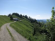
The Hochhäderich (also Hoher Häderich ) is a 1565 m high peak in the Allgäu Alps . It is the westernmost mountain in the Nagelfluhkette and belongs to the Nagelfluhkette Nature Park . The German-Austrian border runs over the summit . The notch height of the Hochhäderich is at least 105 meters, its dominance 2.4 kilometers, with the Einguntkopf being the reference mountain in each case.
tourism
In the winter season, a double drag lift leads from the parking lot to just below the summit. In summer, the easy-to-climb summit is a popular hiking destination. Experienced hikers can continue to climb on a secured path along the Nagelfluhkette in the direction of the Falkenköpfe .
etymology
The Hochhäderich (or Hohe Häderich) is referred to in many map series and especially in older works without an 'e', i.e. Hochhädrich (or Hoher Hädrich ), in the local pronunciation you don't hear any difference. Nevertheless, the name of the mountain should not be traced back to the Old High German surname Hädrich (the rich, mighty), but, like the neighboring mountain Falken, to botanical conditions. It is derived from the collective form "hard" for bushes or pastureland. This reflects the character of the original vegetation on the mountain better. The mountain was first mentioned in 1471 as Harderich .
Web links
References and comments
- ↑ Exact value not known, stated value is a minimum value (can be up to 19 meters higher). It was determined from the distance between the contour lines (20 meters in altitude ) on a topographic map ( scale 1: 25,000).
- ↑ German surnames: Origin H ... ( Memento from February 10, 2013 in the web archive archive.today )
- ^ Thaddäus Steiner : Allgäu mountain names . 2nd Edition. Kunstverlag Josef Fink, Lindenberg 2008, ISBN 978-3-89870-389-5 , p. 87.


