High ridge
| High ridge | ||
|---|---|---|
|
Northern flank of the Hochgrat |
||
| height | 1833.6 m | |
| location | Bavaria , Germany | |
| Mountains | Pre-Alps west of the Iller , Allgäu Alps | |
| Dominance | 12.8 km → Winter shrub | |
| Notch height | 714 m ↓ Starzlachtal watershed | |
| Coordinates | 47 ° 29 '43 " N , 10 ° 4' 43" E | |
|
|
||
| Normal way | Driveway from the valley station of the small cabin lift | |


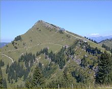
The Hochgrat is a 1834 meter high mountain in the Allgäu Alps . Oberstaufen's local mountain, which is accessible via the Hochgratbahn, is of outstanding tourist and geographical importance as the highest point in the Nagelfluh chain and in the entire Allgäu Alpine foothills.
geology
The layer system of the Nagelfluhplatten raised to the north finds its highest and its central point in the Hochgrat. From its summit, the ridge fades away largely symmetrically on both long sides, then after half a kilometer it drops steeply into a saddle to the next mountain in the chain and at the same time sends a ridge across to the north. This creates the characteristic shape of the high ridge, which together with its continuous ribbon structure makes it appear unique on the north side.
flora
The Hochgrat offers favorable conditions for a lush and species-rich mountain flora: Its calcareous Nagelfluh rock is interspersed with layers of sandstone and marl, so that the plants have a wide range of minerals and substrate structures at their disposal. The climatic exposure of the Nagelfluhkette ensures frequent precipitation and a lot of wind. With a height of Hochgrat reached the tree line (about 1,800 m), which favors some competing with trees mountain flowers.
In addition to most of the meadow flowers, which can also be found in the adjoining valleys, depending on the season, the hiker encounters colorful patches and meadows interspersed with individuals from mountain and limestone aster , thin lady 's mantle ( Alchemilla tenuis ), almost bald hawkweed ( Hieracium subglaberrimum ), Schinz '' Dwarf whitebeam . Blue monkshood , pasque flowers , star umbels , arnica , stone breakers , auricles , stone carnations , yellow and blue spring and stemless gentians , silver thistles and many others.
geography
To the west and north, the high ridge stands in the forefront with its height: in these directions there is no more elevation of nearly the same height on the mainland. On the one hand, this means that from its summit there is a magnificent view in these directions. One overlooks the entire Lake Constance , large parts of Upper Swabia , recognizes the Ulm Minster and the Gundremmingen NPP and guesses the course of the Danube from its band of haze. But it also means that clouds from the usual west and north weather directions very easily hit the high ridge as the first orographic obstacle and start to rain there. For this reason Steibis is one of the wettest places in Germany at the foot of the mountain.
To the south of the high ridge there are several molasse chains that do not reach the high ridge at their height. Only 13 km away do the winter perennials and foothills of the Hohen Ifens exceed its summit height. This means that the Hochgrat has the greatest geographical dominance of all Allgäu mountains . For a climber to the summit, this means that there is no longer a mountain of the same height within a wide radius that obstructs the view. This is why you can see very deeply into the Alps when the weather is clear: in the east the Zugspitze and the Austrian Großvenediger , in the south the Silvretta , the Schesaplana and in Switzerland you can see the massifs of Tödi and Säntis .
The great dominance of the Hochgrat also means that its contour is not disturbed by mountains that tower above it in the background, even at a great distance. In the Westallgäu , in Upper Swabia and also in Kempten (Allgäu) , the striking silhouette of the high ridge is familiar.
The high ridge is bounded to the north by the upper Weißach Valley (also Ehrenschwanger Valley ), to the east by Brunnenaukessel and -scharte from the Rindalphorn, to the southeast by the Aubach in the Gunzesrieder Valley, which is the only one that drains into the Iller and thus into the Black Sea , in the south through the Obergelchenwangtobel watershed , in the southwest through the Leckner Ach in the Lecknertal and in the west through the unnamed saddle and the Lauchalp area from the Seelekopf. The Leckner Ach drains into the Weißach and finally into the North Sea .
Administratively, the Hochgrat belongs entirely to the municipality of Oberstaufen in the Oberallgäu district , the administrative district of Swabia , the state of Bavaria and Germany. Until the regional reform in Bavaria in 1972, the Hochgrat belonged to the municipality of Aach . From 1804 to 1805, Aach and the Hochgrat were Austrian .
The Nagelfluhkette Nature Park, founded in early 2008, also includes the Hochgrat as its highest elevation in the Nagelfluh area.
history
The economic development of the high ridge began on its sunny and fertile south side through the Alpe Gelchenwang. At that time the high ridge was called Obergölchenwanger ridge . Today this name can still be found in the Gelchenwanger Kopf , the pre-summit of the Rindalphorn.
On its north side, its importance was limited to its use as a hunting area until the 18th century. In 1507, for example, the king was mentioned as a hunting guest. Old depictions of the town of Staufen indicate mountain ranges, but the distinctive shape of the high ridge can hardly be seen on them.
It was not until the 19th century that the alpine pastures on the northern flank were also used and forestry was carried out there. With the discovery of the mountain for tourism, its current name, which is easily accessible to tourists, also established itself.
Further stages of the story are
- 1907–1908: Construction of the Staufner House
- 1931: Bavarian ski championship downhill
- around 1936: Planning the road to Balderschwang
- 1968, June 11: A 104 G F StarFighter of the fighter-bomber squadron 34 crashes on the south edge near the summit during the overflight of the Hochgrat. The pilot, a first lieutenant in the Air Force, is killed.
- 1971: Expansion of the route
- 1973: Completion of the Hochgratbahn
- 1996: crash of a sport airplane
- 2004: Installation of panorama camera
- 2006: Cable laying to the mountain station, construction of a chain of lights on the pillars
- 2009: avalanche accident
- 2010: Höhenweg Luftiger Grat is opened
Economical meaning
Alpine farming
The high ridge offers a wide, sunny south side and some Karkessel on the north side for alpine farms , which are mainly stocked with young cattle from June to September. The Alps clockwise (high Alps over 1400 m in italics):
- Simatsgund (Front, Middle, Back)
- Ridge
- Brunnenau (destroyed by avalanche in 1970)
- Goodness
- Gelchenwang Alpe (Untere, Obere) (oldest mentioned Alpe in the Allgäu)
- Lauchalp ( southern , upper , lower)
- Horbach Alpe
- Eibele Alpe
- Flags Alpe
Weather station
Due to its climatically exposed location, the Hochgrat is a good location for recording weather data. The Avalanche Warning Service Bavaria currently operates a measurement data station for wind and temperature at an altitude of 1720 m.
tourism
The Hochgrat is also culturally exposed: to the northwest and north it is the highest elevation in a wide area for large areas (Upper Swabia, western Allgäu), which is also easy to reach and well developed. That is why it is very popular, especially in summer and winter. An extensive infrastructure is available to tourists.
Development
For tourism, the farm road, which was once operated as a toll road, was expanded, paved and opened for general traffic. As an alternative to private transport, there is a regular bus connection between Oberstaufen train station and the Hochgratbahn valley station. The buses run approximately every hour in both directions.
The Hochgratbahn , a small gondola lift, leads from the Weißachtal on the west shoulder of the Hochgrat to the mountain station at an altitude of 1708 m.
The railway created a take-off point for former hang-gliders and now paragliding pilots in the area of the mountain station.
Hosted bases
The Staufner House is a lodging house of the German Alpine Club and section house of the Oberstaufen-Lindenberg section . It stands on the north-western slope just below the connecting ridge to the Seelekopf at an altitude of 1634 m and is open almost all year round.
The mountain station of the Hochgratbahn has a self-service restaurant and is open while the lift is in operation.
There are also some alpine huts and houses that are hosted:
- Obere Lauchalpe (open all year round)
- Lower Lauchalpe (open during the Alpine season)
- Middle Simatsgund (open during the alpine season; with a chapel well worth seeing)
Hiking trails
- Ascent from the valley station car park
- Normal route to the mountain station (2 h) and further to the summit (30 min), the ascent to the mountain station is also possible from Hittisau.
- Via Simatsgund to the Brunnenauscharte (2.5 hours) and from there to the summit (45 min), the ascent from Gunzesried Säge to the Brunnenauscharte takes about 3.5 hours
- High trails from the mountain station
- Crossing to the Brunnenauscharte (45 min), optionally another Nagelfluh ridge hike via Rindalphorn to Sederer or lunch
- The long-distance hiking trails E4 and E5 lead from the Staufner Haus over the summit on the Nagelfluh ridge hike over the Hochgrat
- Panoramic circular route with summit crossing and Alpe Gütle (1 h)
- Airy ridge , balancing act to the falcon
Ski slope
A system of rolled ski slopes runs in the area between the summer gravel path (normal path) and the northwest ridge (possibly the course of the Hochgratbahn). The difficulty levels of the three to six kilometer long downhill variants are between red and black .
The Hochgrat is also often used for ski tours and snowshoe hikes. However, there have been repeated fatal falls and avalanche accidents. In February 2009, an avalanche buried two tourers on the northeast flank. Only one could be saved, the other remained buried more than five meters deep under the snow for two months.
Sporting events
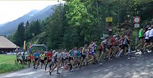
Since 1976 the TSV 1862 Oberstaufen eV has organized the Hochgrat mountain run every year at the beginning of September . The route follows the gravel path from the valley to the mountain station (difference in altitude 850 m, length 6040 m). The course record by Jonathan Wyatt is min at 29:37. Since 2006, a children's competition with a height difference of 74 m has been held.
The Hochgrat ski rally of the German Ski Touring Cup for ski mountaineers has been held on the Hochgrat every year since 2006 .
Others
As early as the 19th century there was a tin bivouac box at the summit as a shelter for hikers who got caught in the weather. This hut was taken over by the newly founded Oberstaufen Alpine Club Section in 1898 and maintained long after the Staufner House was built.
In 1901 a peculiar summit cross was erected. It consists of riveted sheet steel strips and its skeletal structure is reminiscent of the famous steel structures of that time (such as the Eiffel Tower). In winter, an impressive area often forms on this cross. At the same time, two bench seats were installed on both sides.
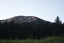
In some springs, snow remains in the form of the handwritten number 1927 on the northeast flank . This snow figure was particularly clear in 1927, which led to all sorts of miraculous beliefs.
Today's normal route to the ridge between Hochgrat and Seelekopf (approx. 1600 m) was upgraded to a gravel road for trucks on the occasion of the construction of the Hochgratbahn . In the 1930s, a regular road to Balderschwang was even planned over this route . Balderschwang was a functional exclave at the time , as it could only be approached via Austria. Before the planning was implemented, however, Austria was annexed to the German Empire, so that there was no need. After the war, the plan was not taken up again, but the connection of Balderschwang through the Riedbergpass was achieved.
A large hotel was also only planned and not implemented in 1959. Following the example of some Swiss buildings, not only a luxurious hotel was planned on the summit of the Hochgrat, but also a cable car as a feeder, whose valley station could be reached on foot from Oberstaufen would. The project was discarded in favor of a hotel in Oberstaufen.
literature
- Dieter Seibert: Alpine Club Guide Allgäu Alps. Bergverlag Rother , ISBN 3-7633-1126-2
- Oberstaufen-Lindenberg section: 100 years of the DAV Oberstaufen-Lindenberg section , Festschrift, Holzer printing house, 1997
- Robert Braun: The most beautiful Upper Swabian local mountains. Biberacher Verlagsdruckerei, ISBN 3-924489-88-2
- Kompass hiking, cycling, ski touring and cross-country skiing maps : Oberstaufen, Immenstadt im Allgäu , KOMPASS maps, Innsbruck, ISBN 3-85491-004-5
Web links
Individual evidence
- ^ Official map - digital local map 1:10 000. In: BayernAtlas. State Office for Digitization, Broadband and Surveying Bavaria , accessed on January 12, 2016 .
- ↑ Hochgrat . Retrieved March 27, 2011.
- ↑ a b c Bavarian State Office for the Environment : Regionalized flora list of Bavaria (PDF; 2.2 MB). Retrieved March 27, 2011.
- ↑ a b Report of the Natural Science Association for Swabia and Neuburg (aV) in Augsburg . 1898. Retrieved March 27, 2011.
- ↑ Nagelfluhkette Nature Park, Sibratsgälle. (No longer available online.) Formerly in the original ; Retrieved October 27, 2011 . ( Page no longer available , search in web archives ) Info: The link was automatically marked as defective. Please check the link according to the instructions and then remove this notice.
- ^ Thaddäus Steiner : Allgäu mountain names . 2nd Edition. Kunstverlag Josef Fink, Lindenberg 2008, ISBN 978-3-8987-0389-5
- ↑ F-104 Losses - crashes or segregation after severe damage . Retrieved March 25, 2011.
- ↑ Allgäu advertising paper: Huge avalanche on the Hochgrat ( page no longer available , search in web archives ) Info: The link was automatically marked as defective. Please check the link according to the instructions and then remove this notice. . February 19, 2009. Retrieved March 25, 2011.
- ↑ Markt Oberstaufen: History ( page no longer available , search in web archives ) Info: The link was automatically marked as defective. Please check the link according to the instructions and then remove this notice. . Retrieved March 25, 2011.
- ↑ Alpine-Tobel-See hike in the Nagelfluhkette Nature Park . Retrieved March 25, 2011.
- ↑ Avalanche warning service Bavaria: Hochgrat measurement data ( memento of the original from July 19, 2011 in the Internet Archive ) Info: The archive link was automatically inserted and not yet checked. Please check the original and archive link according to the instructions and then remove this notice. . Retrieved March 27, 2011.
- ^ Oberallgäu district: timetables for buses . Retrieved March 25, 2011.
- ↑ Hochgrat 1800 meters . Retrieved March 25, 2011.
- ↑ a b Alpin.de : Ski tour: Nagelfluhkette . Retrieved April 23, 2015.
- ↑ Spiegel-online: Ski tours in the Allgäu: Off the beaten track . Retrieved April 2, 2011
- ↑ Augsburger Allgemeine : Avalanche victims found . April 18, 2009. Retrieved March 25, 2011.
- ↑ Trailrunning Cup stops in Oberstaufen: Hochgratberglauf is the eighth run in the series . Retrieved March 25, 2011
- ^ Children's mountain run , TSV 1862 Oberstaufen eV
- ↑ Picture from the summit on the Hochgrat (flickr.com) . Retrieved March 25, 2011.


