
Riedberg Pass
| Riedberg Pass | |||
|---|---|---|---|
 View from the Riedbergpass to the Riedberger Horn in the north-west; |
|||
| Compass direction | west | east | |
| Pass height | 1407 m above sea level NHN | ||
| state | Bavaria | ||
| Watershed | Bolgenach | Schoenberger Oh | |
| Valley locations | Hittisau | Fishing in the Allgäu | |
| expansion | Street | ||
| Built | 1961 | ||
| Lock | no | ||
| particularities | Highest passable road in Germany | ||
| profile | |||
| Ø pitch | 3.1% (531 m / 17 km) | 7.1% (621 m / 8.7 km) | |
| Max. Incline | 16% | 16% | |
| map | |||
|
|||
| Coordinates | 47 ° 26 '13 " N , 10 ° 10' 38" E | ||


The Riedbergpass is 1407 m above sea level. NHN the highest passable mountain pass in Germany . It is located near the eponymous Riedberger Horn ( 1787 m ) in the Allgäu Alps on the OA 9 district road between Obermaiselstein and Balderschwang in the Bavarian district of Oberallgäu .
Specialty
Only the Roßfeldhöhenringstraße , which has a special position among the mountain roads on the Ahornbüchsenkopf east of Berchtesgaden , and some dead ends, for example on the Grünten , lead to even higher places in Germany than on the Riedbergpass. However, these are not actual pass roads, but in contrast to a pass that has two driveways, only circular roads or mountain arrivals. The Schrofenpass is higher , but it is only passable on foot or by mountain bike.
geography
location
The Riedbergpass is one of the westernmost points of the Bavarian Alps in the Allgäu Alps in the southwest of the Oberallgäu district in the German state of Bavaria. Southwest closes the Bregenzerwald at which, among other things in the Austrian land Vorarlberg spreads.
The mountain pass is located in the Hörnergruppe between the Riedberger Horn in the northwest, the Wannenkopf ( 1712.2 m ) in the northeast, the Besler ( 1679.4 m ) in the southeast, the Schafkopf ( 1627 m ) in the south, the Gauchenwände ( 1479 m) ) with the Piesenkopf ( 1629.6 m ) in the southwest and the Hochschelpen ( 1552 m ) in the west. It lies between Obermaiselstein (northwest of Oberstdorf ) in the east and Balderschwang (on the border with Vorarlberg) in the west. Until the opening of the street, the smallest Bavarian community, Balderschwang, was only accessible for motor vehicle traffic via Vorarlberg.
The Riedbergpass is the lowest road pass between Obermaiselstein and Balderschwang, but about 650 m south-southwest of the pass and 250 m west-northwest of the Schönbergalpe ( 1330 m ) is the Schönbergjoch (approx. 1345 m ) as the lowest yoke between the Riedberger Horn and the Besler; about 250 m southwest of the yoke is a 1360 m high elevation.
Natural allocation
→ see also the section on the natural allocation of the article Riedberger Horn
The Riedbergpass belongs to the natural spatial main unit group Flyschalpen (No. 94), in the main unit Vorarlberger and Westallgäu Flyschalpen (940) and in the subunit Northern Vorarlberg and Westallgäu Flyschalpen (940.0) to the natural area Riedberghorngruppe (940.00).
Rhine-Danube and European main watershed
The Rhine-Danube watershed , which is part of the main European watershed , runs over the Riedberger Horn, located northwest of the Riedberg Pass, and the Schafkopf, located south of the pass :
The water of the (western) Bolgenach , which rises 3.8 km south-southeast of the Riedberger Horn and 1.9 km south of the pass at the southern foot of the Schafkopf, reaches through the Weißach , Bregenzer Ach , Lake Constance and the Rhine in a predominantly north-westerly direction North Sea .
In contrast, the water of the hamlet of Ach , which arises 4.4 km east-northeast from its two source streams, the left (eastern) Bolgenach and the right Schönberger Ach , which flows a few meters west of the pass , runs through the Iller and the Danube in a mainly east-southeast direction in the Black Sea ; the source streams arise north or south of the ridge near the pass between Riedberger Horn in the west and Wannenkopf in the east.
Pass height
The top of the Riedberg Pass is at 1407 m . On the mountain pass there is a sign with the wrong height indication "Passhöhe 1420 m above sea level" . A trigonometric point near the pass is at 1,405.9 m . The highest point of the Riedbergpassstrasse at 1407 m is not on the watershed, which is about 900 m further in the direction of Balderschwang at an altitude of 1380 m .
Pass road
If the pass road is still bend-free at the beginning, the road layout from Obermaiselstein becomes quite winding and steep. The access road to the Riedbergpass branches off in Germany at Fischen from Bundesstraße 19 and in Austria near Hittisau from Hittisauer Straße ( Landesstraße 205). The road, which is very costly to maintain, has so far been classified as Kreisstraße OA 9 on the German side , and because of its importance as the shortest connection between the Austrian exclave Kleinwalsertal and its district and provincial capital Bregenz , the district responsible for this requires classification as a Bavarian state road. On the Austrian side, the L 5 , known as Balderschwanger Straße , leads to the state border at Balderschwang.
The pass road leads from the east of Fischen ( 761 m ) along the Schönberger Ach via Obermaiselstein ( 849 m ) westwards up to the Riedbergpass. Beyond this, it runs west-northwest downhill through the Bolgenach valley down to Balderschwang ( 1044 m ), where it leads through the districts of Schwabenhof ( 1071.2 m ), Wäldle, Balderschwang, Gschwend and Schlipfhalden ( 1043.6 m ). In the Balderschwanger valley there, the road crosses the German-Austrian border ( 1052 m ) west of Schlipfhalden, about 10.5 kilometers west of the pass on the southwest flank of the Nagelfluh chain rising north of it ; there the small Doserbach is bridged, which comes from the nearby Samstenberg ( 1513.4 m ) and flows south into the Bolgenach. From the end (in Hittisau 790 m branches) ending Passstraße apart from the after Sibratsgfäll leading Sibratsgfäller street from only a few dead ends until reaching the Hittisau local area, such as west of the pass to the north of Grass Gehrenalpe (about 1450 m ).
The pass road has a gradient of up to 16% on both ramps, with a distance of around 16 km from Fischen to Balderschwang; to Hittisau this is even 28 km. From Fischen to the mountain pass there is a difference in altitude of 646 m, from the pass to Balderschwang 363 m and from the pass (through Balderschwang) to Hittisau 617 m.
Between Obermaiselstein and Balderschwang there is a ban on vehicles with a gross vehicle weight of more than 19 tons in both directions. The maximum passage height of the 60 m long tunnel under the Burgschrofen in Obermaiselstein is 3.8 m. A pedestrian and cycle path bypasses this tunnel.
photos

East ramp, tunnel in Obermaiselstein im Burgschrofen (left), tunnel bypass for cyclists and pedestrians (center), the Schönberger Ach (right)

East ramp, in the background the thumb group

West ramp between the pass and Balderschwang
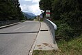
West ramp, bridge over the Doserbach with the German-Austrian border; Looking west towards Austria


Web links
- The geology is the origin of all evil , article in the Allgäuer announcement sheet of 23 September 2008 (about road maintenance and expansion).
Individual evidence
- ↑ a b c Map services of the Federal Agency for Nature Conservation ( information )
- ^ Hansjörg Dongus : Geographical land survey: The natural spatial units on sheet 187/193 Lindau / Oberstdorf. Federal Institute for Regional Studies, Bad Godesberg 1991. → Online map (PDF; 6.1 MB)
- ↑ Bavaria Atlas of the Bavarian State Government ( notes )
- ↑ Austrian Map online , at austrianmap.at
- ↑ Ascent and descent according to the signs on the pass road
- ↑ Maximum headroom according to the signs on the tunnel portals