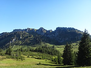
Besler (mountain)
| Besler | ||
|---|---|---|
|
Beslergruppe, from left: Besler (main summit), Beslergrat, Beslerkopf, Schafkopf |
||
| height | 1679.4 m above sea level NHN | |
| location | Bavaria , Germany | |
| Mountains | Allgäu pre-Alps west of the Iller , Allgäu Alps | |
| Dominance | 2.4 km → tub head | |
| Notch height | 273 m ↓ Riedbergpass | |
| Coordinates | 47 ° 25 '31 " N , 10 ° 11' 17" E | |
|
|
||
| rock | Helvetic chalk | |
| Age of the rock | Helvetic | |
The Besler is a 1,679 meter high mountain in the Allgäu Alps .
Location and surroundings
The Besler is located on the southern side of the Riedbergpass , a pass road in the Oberallgäu district that connects Obermaiselstein with Balderschwang and further with the Austrian Vorarlberg . The mountain lies between the mountain valleys of Lochbach in the south and Schönberger Ach in the north.
In addition to the main or east summit, the Besler also has a central summit called Beslerkopf ( 1655 m above sea level ) and a western summit, the Schafkopf ( 1602 m above sea level ). In addition, an inconspicuous elevation between the Besler and Beslerkopf is known as the Beslergrat ( 1668 m above sea level ).
geology
The rocky summit of the mountain protrudes in a characteristic way ("like a wall") from the surrounding mountain meadows. It consists of the sedimentary rock of the Helvetic Chalk, which is less common on the surface of the Allgäu Alps . The Hohe Ifen , parts of the Grünten , the Diedamskopf in the Bregenzerwald and the Säntis in Eastern Switzerland are built from this rock . On the south side of Besler there is a karst landscape.
Naming
The name Besler is said to go back to a man from Basel . He once created several Alps on this mountain .
Ascent
Possible starting points for a mountain hike on the Besler are Obermaiselstein ( 859 m above sea level ), Tiefenbach ( 880 m above sea level ), Rohrmoos ( 1070 m above sea level ) or Grasgehren ( 1450 m above sea level ) on the Riedbergpassstrasse.
The tour from Obermaiselstein leads past the nearby Sturmannshöhle , to which a detour is possible. On the Königsweg , a hunting trail named after King Max II of Bavaria , you get to the Schwarzenberg hunting lodge . From there the path continues over the Obere Gundalpe over a short via ferrata ( difficulty A / B ) to the summit. This takes about three hours.
About the same time is needed from the Oberstdorf district of Tiefenbach. Here the path leads over the Lochbach valley to the Besler. From Rohrmoos you have a higher starting point, but you first have to change from Starzlachtal to the neighboring Lochbachtal. The total time required for the ascent is around two and a half hours.
From the Riedbergpass you first have to descend to the Schönbergalpe ( 1345 m above sea level ) on the northern Besler slope . The total time to the summit is around one and a half hours.
In terms of ice and snow conditions, the Besler can already be climbed from mid to late May, whereby the south-facing variant from the Lochbachtal is favored. In early summer, a multitude of mountain flower species bloom on the mountain, such as white silver arum , gentian and auricles .
Web links
Individual evidence
- ↑ Peter Nowotny: The beautiful Allgäu , special issue on the go with a backpack and PS , AVA Agrar-Verlag-Allgäu, Kempten (Allgäu) (no year).
- ↑ Klettersteig.de , accessed on September 5, 2013


