Gunzesried
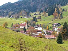
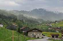
Gunzesried is a district of the Bavarian municipality of Blaichach im Allgäu . It is located almost 900 m above sea level in a high valley.
history
According to dialect researchers, the place name goes back to "Gunzharts Ried" and offers an indication of the settlement of the valley by Alemanni , which took place in the 7th century. These first inhabitants made the marshland ( reed ) arable. About 100 years after the first settlement, the inhabitants were converted to the Christian faith by missionaries from the St. Gallen monastery . At that time the first chapel in the village was built. The successor to this first Christian church, the Chapel of St. Nicholas , was consecrated in 1612.
Towards the end of the 13th century, the Alpgau County was converted into the County of Eglofs. The so-called "Obere" and the so-called "Untere Sturz", however - tax communities that controlled the county of Eglofs - reserved their own jurisdiction in property matters and the independent choice of their local board or mayor until 1809 and 1810 respectively. The last mayor of Gunzesried who made up the Upper Fall was Johannes Finkel.
A part of the coal that was needed for ore extraction under the Grünten was obtained from the Gunzesrieder valley . In 1708 there was a strike. The demands of the coal transporters for better pay were given in, so that there were no obstacles to work in the mine .
In 1796 Gunzesried was affected by the armed conflict with France. Schultheiss Finkel wrote a report about it: “Since the Roman Emperor and the Teutsche Reich were still involved in a very, very difficult war with the French Republic, we had very large costs, heavy deliveries and wagons for magazines and soldiers, and so on it so happened that all the allies had to give way to the French. It was a terrible retirade, because that from Unterwaben very heavily fled into our mountains against cattle and various furniture and also handsome people themselves. So we parishioners gave the then ruling Count Franz Fidel v. Königsegg-Rothenfels with 15 horses picked up some of his most valuable furniture in Gunzartsried to flee and placed in the Thomas Renn, the next house near the chapel, and put up a watch every night for several weeks. Otherwise a lot of private things have been on the run with us. On August 24th, a stubborn skirmish between the imperial and the French took place near Immenstadt . The imperial had to retire and the fighting and cannoning went as far as Obersonthofen. It had been going on all day. It looked sad then. The French stole and plundered everything they liked wherever they went, and many people were treated badly too. Not only a hundred people have fled to our community [...] Some French troops roamed through Schwanden and Ettensberg to the Reithe community , where they stole what they liked from some farmers. From the Reithe they beat their way across the ravine onto the dump and did not treat this place well either. We were in fear in our community, especially because we had so many refugees with us and more and more people came in every hour. Given the nature of the situation, the community superiors at that time took flight to God and the King of Heaven, Maria, as well as to our patron saint, St. Nicholas , and asked in the name of the whole community to avert all evil, with the serious promise to make a reminder every year . What happens: the French looked into the Gunzesried on the heights and withdrew again! On August 25th another great alarm was raised [...] The deputies from the parish renewed their miserable promise with firm confidence, and everything remained safe with us, and we did not see a single Frenchman in our village that year [. ..] "
The hunting sovereignty once lay with the bishops of Augsburg and the counts of Königsegg. A follow-up phenomenon to the revolution of 1848 was the release of hunting to the communities, which led to a sharp decline in the game population in the Gunzesrieder valley. The introduction of the new hunting law in 1850 put a stop to this. The Allgäu hunting society, which was founded in 1854 and consisted mainly of noble gentlemen, also used the Gunzesried area among others.
In 1908 the community of Gunzesried - to which Seifriedsberg and Bihlerdorf still belonged - had 783 inhabitants, but the village itself only had 384. In 1808 a desertification had begun, the traces of which were still clearly visible.
Attractions
The St. Nicholas Chapel is a registered monument . It was built in the early 17th century; The retaining wall on the steep northern flank of the so-called Kappel-Bichl slipped several times, making repairs necessary. The last extensive renovation took place in 2017. A solemn mass has been held on St. Nicholas Day since 1796 because of a vow: many people fled to the valley from Napoleon's troops, their prayers were answered and the place was spared from the marauding troops.
The Ostertaltobel is located near Gunzesried .
At the lower end of Gunzesried is the beginning of the hiking trail through the Haldentobel, which Max Förderreuther once described as follows: “The Gunzesried valley is also rich in scenic beauty. The Aubach , which flows through it, forms a wild narrowness above the new bridge , in which giant blocks block the path of the raging water. Later, around Gunzesried, the steeply sloping terraces show that the water was once dammed up into a sizable lake here, until he succeeded in sawing through a second narrow, which begins just below Gunzesried and with small interruptions until it emerges from the mountains continues at Blaichach. Who is | One cannot regret the inconvenience of following the streambed as far as possible, one can watch one rare natural spectacle after another. Soon there are round whirlpool holes that have been drilled spirally into the hard rock; soon rocky transverse ribs push forward, which the brook has cut sharply in two as if by means of a saw; soon boulders pile up, between which the water foams away in wild anger; in addition beautiful, tall forests and on hot summer days a welcome opportunity to take a refreshing bath in the clear, fresh mountain water! "
An old suspension bridge between Gunzesried-Säge and Gunzesried was demolished in 1901 before the new high bridge was built. The Gunzesrieder farmer Martin Schneider built a wooden model of the old bridge on a scale of 1:10, which - in terms of scale - had the same load-bearing capacity as its model. The new bridge, a reinforced concrete structure, existed into the 21st century and was demolished against the resistance of monument conservationists. A photograph by Heimhuber shows the building that spanned a deep ravine.
Web links
Individual evidence
- ↑ So Irene Gehring in her church guide The Most Blessed Virgin and St. Nikolaus , Gunzesried 1996, o. S. Another source translates the place name with "clearing of Gunzo".
- ↑ Irene Gehring, The Most Blessed Virgin and St. Nicholas. A guide through the chapel in Gunzesried , Gunzesried 1996
- ^ Max Förderreuther, The Allgäu Alps. Land and people , Kempten and Munich ²1908, p. 216 ( digitized version )
- ^ Max Förderreuther, The Allgäu Alps. Land and people , Kempten and Munich ²1908, p. 437 f. ( Digitized version )
- ↑ Finkel's report is quoted from a leaflet St. Nikolaus and the Gunzesrieder. A solemn engagement , n.d. , n.d.
- ^ Max Förderreuther, The Allgäu Alps. Country and people , Kempten and Munich ²1908, p. 191 ( digitized version )
- ^ Max Förderreuther, The Allgäu Alps. Country and people , Kempten and Munich ²1908, p. 316 ( digitized version )
- ^ Max Förderreuther, The Allgäu Alps. Land and people , Kempten and Munich ²1908, p. 67 f. ( Digitized version )
- ^ Max Förderreuther, The Allgäu Alps. Country and people , Kempten and Munich ²1908, p. 237 ( digitized version )
- ↑ Photo of Heimhuber's "new bridge" at the time
Coordinates: 47 ° 31 '20.86 " N , 10 ° 13' 43.11" O


