
Pledges
| Pledges | ||
|---|---|---|
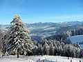
 The Pfänder from the pier in Bregenz |
||
| height | 1062 m above sea level A. | |
| location |
Lochau near Bregenz Vorarlberg Austria |
|
| Mountains | Allgäu Alps | |
| Dominance | 3.3 km → Hirschberg | |
| Notch height | 75 m ↓ last to the Hochberg | |
| Coordinates | 47 ° 30 '27 " N , 9 ° 46' 49" E | |
|
||
| rock | Nagelfluh | |
| Development | Street, Pfänderbahn | |
| Normal way | Motorway or various walking and hiking trails from Bregenz or Lochau | |
| particularities | Berghaus Pfänder, alpine game park, kiosk, children's playground | |
 On the pledge |
||

The 1062 m above sea level. A. high pledges is one of the Allgäu Alps and lies at the eastern end of Lake Constance . It is considered to be the “ local mountain ” of Bregenz , but is largely located in the municipality of Lochau . With its unique view of Lake Constance and 240 Alpine peaks, it is the most famous vantage point in the region.
geography
When the weather is clear, the four-country view (Austria, Germany, Switzerland, Liechtenstein) extends from the Allgäu and Lechtal Alps in the east over the Bregenzerwald , the steep peaks of the Arlberg region and the Silvretta , further over the Rätikon to the Swiss mountains and the foothills of the Black Forest in the west. At its feet lies Lake Constance, framed by the Rhine Valley and the Upper Swabian hill country. The difference in altitude from Lake Constance to the summit is 667 meters.
Below the summit there is an alpine game park with native animals, in which u. a. Alpine ibex , wild boar and red deer can be observed. There is also an eagle observatory where demonstrations of birds of prey flights took place from May to October . However, it has been closed since autumn 2014.
There is a dense network of hiking trails and a cable car for visitors and hikers. Two ski lifts are in operation for skiers in winter. A narrow, single-lane road leads from Eichenberg and Lochau to the mountain station and the summit restaurant. There are several inns and private accommodations along the streets.
Near the top of the stands transmitter pledges of the Austrian Broadcasting Corporation for Radio and Television. A 94.7 meter high, free-standing steel framework construction built in 1958 serves as the transmission tower.
geology
The pledges belongs to the geological prealpine molasses that during the in Paläogen (66 mya onset) Alpenauffaltung in prealpine tank during Neogene formed and deformed with continued Orogenese and folded. The coarser parts of the molasse remained close to the Alps and formed the so-called Nagelfluh and sandstones, as they emerge on the Pfänder in the wall crashes of the "Känzele" under the Gebhardsberg .
history
The Wellenstein Cave is located on the ascending Pfänder slope, above Lochau . Excavation finds there point to a settlement in the Late Bronze Age.
During the Thirty Years' War , the Swedish Reichsfeldmarschall Carl Gustav Wrangel occupied Hofen Castle above Lochau in 1646 and prepared the attack on Bregenz. This took place surprisingly on January 4, 1647 from the Pfänder. The defensive positions of the imperial on Haggen and on the Pfänder were overrun, the Swedes (8000 men) are said to have followed the traces of the defending defenders in the snow. This flank of the Pfänder is still called the Schwedenhang today. In 2007, the municipality of Lochau set up the themed hiking trail "Schwedenweg anno 1647" with explanatory boards on existing hiking trails.
At the beginning of the 20th century there were plans to build a steam- or electric-powered rack railway on the Pfänder. They remained unrealized.
In contrast, the company Adolf Bleichert & Co. built a cable car from Bregenz to the summit ridge in 1927 and has since been renewed several times. The valley station of this aerial tramway is 419 m above sea level. A. , the mountain station is 1022 m above sea level. A.
In 1973, in order to defuse the bottleneck between the Pfänder and Lake Constance, a tunnel was planned from the north, near the border with Germany, to the south through the Pfänder. 1975–1980 the construction of one tube was carried out. The motorway tunnel of the Rheintal / Walgau Autobahn (A14) got a second tunnel tube between 2007 and 2012.
In 2018, the discovery of several molars from a gomphotherium on the Pfänder became known.
Hiking and pilgrimage routes
Three-thousand-meter mountain hike
Pfänder mountain station ( 1022 m ) - Pfänderspitze ( 1062 m ) - Hub - Hirschberg ( 1095 m ) - direction Jungholz - Trögen - Hochberg ( 1069 m ) - Schüssellehen - Letze - Höhenweg to mountain station
- (19 kilometers, walking time around 5 hours)
Cheese hiking trail
Pfänder mountain station ( 1022 m ) - Moosegg - entrance to the cheese educational trail with display boards, cheese factory visit possible - Trögen - Hochberg ( 1069 m ) - Schüssellehen - Lutzenreute - Eichenberg village - Pfänder
- (Walking time between 3 and 4½ hours)
Way of St. James
The Way of St. James , which runs from Munich to Einsiedeln in Switzerland, runs over the Pfänder . In Möggers the pilgrim crosses the Austrian border, after Lustenau he leaves Vorarlberg towards Widnau in the canton of St. Gallen .
photos
View from the Pfaender towards the Bregenzerwald

View of Lake Constance and Lindau

Pfänderbahn valley station built in 1926 by Willibald Braun

Pfänderbahn mountain station
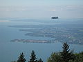
Lake Constance - View of the city island of Lindau

View of Bregenz

Pfänder with Bregenz from eastern Lake Constance

Planning of an electric rack railway by Friedrich Wilhelm Schindler

Radio tower on the top of the Pfänder

View from the Pfänder to Lake Constance


.JPG)
.JPG)
.JPG)


Web links
- Pfänder - adventure mountain and excursion destination on Lake Constance
- Pfänderbahn
- Webcam Pfänder - Bregenz
Individual evidence
- ↑ Pfänder Alpine Wildlife Park. In: pfaender.at. Ferdinand Kinz KG, accessed on December 4, 2015 .
- ↑ Ulrich Stock: Future of the eagle observatory uncertain. In: suedkurier.de. June 19, 2015, accessed May 19, 2016 .
- ↑ Ulrich Stock: Off for the eagle station on the Pfänder. In: suedkurier.de. February 10, 1016, accessed May 19, 2016 .
- ↑ History: Historical outline. In: lochau.at. Lochau community, accessed on December 4, 2015 .
- ↑ New mountain railway . In: Wiener Zeitung . Vienna May 2, 1907, p. 11 ( online [accessed July 25, 2009]).
- ↑ Pfänderbahn Museum: The history of the Pfänderbahn is shaped by far-sightedness. In: pfaenderbahn.at. Retrieved December 4, 2015 .
- ↑ Urelefant left traces on pledges . orf.at, June 4, 2018; accessed on June 4, 2018.
- ↑ a b The scenic hiking paradise of Pfänder. (PDF; 92 kB) In: pfaenderbahn.at. Pfänderbahn, accessed on December 4, 2015 .
- ↑ a b hiking suggestions. In: pfaender.at. Ferdinand Kinz KG, accessed on January 19, 2017 .