
Vennbahn (bike path)
| Vennbahn | |
|---|---|
|
|
|
| overall length | 130 km |
| location |
|
| map | |
 |
|
| Starting point | Aachen |
| Target point | Troisvierges |
| Places along the way | Aachen - Brand - Kornelimünster - Walheim - Schmithof - Raeren - Roetgen - Lammersdorf - Konzen - Monschau - Kalterherberg - Sourbrodt - Weywertz - Waimes - Ondenval - Born - St. Vith - Reuland Castle - Troisvierges |
| Flooring | mostly paved |
| Height difference | Ascent 1011 m, descent 760 m (lowest point: Aachen 180 m above sea level , highest point: Sourbrodt 563 m above sea level ) |
| difficulty | easy, with the exception of the bypass at the Lengeler tunnel (12% over 1.5 km) |
| Traffic volume | low |
| Connection to |
|
| ADFC certification | 4 out of 5 stars |
| Website URL | vennbahn.eu |

The Vennbahnradweg is a cross-border long-distance cycle path between Germany, Belgium and Luxembourg, which runs on the route of the now former Vennbahn , which was built at the time of Prussia , over around 130 km from Aachen through the Hohes Venn-Eifel nature park and the Ardennes to Troisvierges (German: Ulflingen ) . It is part of the RAVeL network (French: Réseau Autonome de Voies Lentes ), which is a network of trails for hikers, riders and cyclists in Wallonia, Belgium and was launched in October 1995. In German-speaking countries, the hiking and cycling route was named Vennbahn and its total length is classified as a premium bike route .
The cycle and hiking trail is popular with many cyclists, skaters and hikers, and the neighboring communities promise an increase in local tourism in the future. This is supported by the fact that some former train station buildings have already been converted into rest stops, hotels and pensions are setting up for day tourists and local public transport provides so-called bicycle buses as shuttle services. In the course of 2013, seven little steel houses were built between Roetgen and Kalterherberg in the shape of a “lost wagon”, which are intended as weather protection or a resting place.
In the area of Wallonia z. Some of the still existing bus shelters for the railway have been preserved and sometimes lovingly cared for (see Faymonville ).
Development and course
After Belgium had shut down train traffic on the Vennbahn , an alternative, tourist use was sought to maintain and continue using the route . The Vennbahn route as the longest cross-border, continuous cycle and hiking route in Europe on disused railway lines was created through the cooperation of the “ Euregio Maas-Rhine ” and the greater region of Saar-Lor-Lux in the Interreg project IVA . The total costs amount to 13.6 million euros (as of 2012). The EU, Germany, Belgium (Wallonia and the German-speaking Community), Luxembourg and various municipalities and companies are the main contributors.
The route between Aachen and Schmithof (border) lies in Germany, from about the border northwest of Roetgen to the border Kalterherberg, the route runs partly through Germany, but it is Belgian national territory. In the Wallonia area, it leads through several language areas :
- Municipalities in the French Community of Belgium with language facilities for German speakers
- Municipalities in the German-speaking community of Belgium with language facilities for French speakers.

At the former Hemmeres exclave , this route temporarily leaves the route and Belgian territory and leads back through Germany for a few 100 m. The stretch between Lengeler (from the Wilwerdingen tunnel) to Ulfingen is part of Luxembourg.
The Vennbahn bike / hiking trail itself leads mainly on the railway line, but also roughly parallel to it in places.
Belgium incorporated the cycle path running on the Vennbahntrasse from Raeren via KalterherbergSourbrodt, Waimes to St. Vith as route 48 and the route St. Vith-Oudler-Ulfingen as route 47 into the RAVeL network .
The cycle path leads from Aachen via Monschau , Waimes and Sankt Vith to Troisvierges in Luxembourg (German: Ulflingen ) over a total of 130 kilometers with very low gradients typical for railways, with the exception of the 12% gradient during the permanent diversion at the Wilwerdingen tunnel near the Belgian town of Lengeler and the Luxembourg border. Sourbrodt is the highest place on the route.
After the line to Walheim had already been completed on the German side in 2008, the sections leading through the area of the Aachen city region were originally supposed to be completed in 2011. For the Roetgen - Lammersdorf section , however, preliminary work could not begin until the end of 2010, followed by the Walheim - Roetgen and Lammersdorf - Kalterherberg sections . On the latter section, it was the black grouse in particular that led to a massive delay. There were also problems in German territory when crossing the heavily trafficked federal highway 258 , which had to be given special attention in the interests of safety. At first a bridge was considered, but it was decided to build an underpass. Another difficulty arose when it was discovered that the excavated earth between Schmithof and Raeren had not been properly disposed of, but had been piled up on the side of the cycle path.
On Belgian territory, there was a conflict of interests with nature conservation, as the route between Kalterherberg and Sourbrodt through a Natura 2000 site results in which the now very rare whinchat breed. These problems were resolved with the compromise to build an alternative route. In October 2013, the modified route in this section was approved. In contrast, the section from Waimes to Sankt Vith has been used for tourism for years and has had a connection to Prüm in the German Eifel since autumn 2007 .
On the border with Luxembourg, the Wilwerdingen tunnel (790 m) near Lengeler is closed for environmental reasons and is no longer being repaired, which necessitated an asphalt bypass route with a maximum gradient of 12% (1.3 km). The entire route was officially opened on July 2, 2013, and the total cost was EUR 14.7 million. On September 15, 2013, the last section to Kalterherberg was officially opened in Simmerath-Lammersdorf.
Legal specifics
Due to the special situation that individual sections run alternately on German and Belgian territory, the respective national road traffic regulations apply. In the event of an accident, the free international emergency number 112, which is uniformly used between Germany, Belgium and Luxembourg, must be dialed and the location notified. For this purpose, so-called rescue points with kilometer information, emergency number and another number that provides information on the location have been installed in German territory at regular intervals. From Aachen to behind Kalterherberg, the probability is very high that you will first end up with the German rescue services and police stations via mobile phone network. If necessary, this informs the Belgian control center where a German-speaking employee is located. Nevertheless, the German rescue service usually drives to the scene of the accident, because it was the first to be alerted and can often be the first to be on site. This regulation has existed since the Versailles Treaty.
However, the German police are not allowed to intervene in the event of accidents and / or criminal reports on Belgian territory. In addition, there may be unexpected complications, as German civil law only applies to the Belgian route if all those involved (those involved in the accident) come from Germany. There are also significant differences in the amount of compensation for pain and suffering in Belgium and Germany. If in doubt, an expert should be consulted.
Connections (selection)
At various junctions on the Vennbahn cycle path there are connections to both other long-distance cycle paths and local cycle path networks, including:
- the Stolberger Vennbahnroute, 9.7 km, Stolberg (old town) -Breinig-Kornelimünster-Abzw. Hahn, formerly a double-track Vennbahn branch.
- the Rurufer cycle path , which comes from the Botrange and crosses the Vennbahnweg at Kalterherberg and runs via Monschau, Heimbach , Jülich with a total length of 180 km to Roermond .
- the Eifel-Höhen-Route , which crosses the Kalterherberg junction with a total length of 230 km as a circular route from Blankenheim and is identical to the Rurufer cycle path until Heimbach, but then goes back to Blankenheim via Mechernich .
- the Eifel-Ardennen-Radweg , which branches off the Vennbahnweg at St. Vith and runs over Prüm and Gerolstein over a total length of approx. 112 km to the Nürburgring .
- the RAVeL-Weg L45, which comes from Trois-Ponts via Stavelot and Malmedy to Waismes and there meets the Vennbahnweg
- the RAVel-Weg L45a, which branches off the Vennbahn in Weywertz and leads on the Vennquerbahn to Losheimergraben (border). From the border it continues on the railway line as the Kylltal cycle path via Stadtkyll and Jünkerath with continuation to Trier .
- the cyclable du Nord PC21 piste, which begins in Huldange , a district of the Troisvierges municipality and runs with a total length of 47 km via Clervaux to Kautenbach .
- Pictures from the Vennbahnradweg

Vennbahnradweg near Kornelimünster
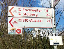
Vennbahn route from / to Stolberg

Vennbahn rest area Monschau

Rollefbach Viaduct

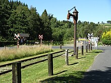
Vennbahn Remains of the former locomotive turntable
Vennbahnweg near Kalterherberg during the expansion phase

A tunnel on the Vennbahn
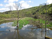
A view from the route

Vennbahnweg for pedestrians and cyclists near Ondenval (B)

Amel Born Viaduct

in Belgium as a hiking, cycling and, in some areas, also as a bridle path
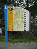
Information boards on the history of the Vennbahn

Vennbahnradweg signs on the St. Vith-Aachen section

Looking back to Ulflingen station


Awards
- "European Greenways Award" of the European Greenways Association (September 2013)
- "Bike Course of the Year 2014" as part of the "Fiets Awards" (March 2014)
- "Quality route with four stars", awarded by the ADFC at the Berlin International Tourism Exchange
- "Excellent Award in the Region" category at the international film competition "Das goldene Stadttor 2015" for the Vennbahn film "A path of transmission"
literature
- The Vennbahn. On the bike from Aachen to Luxembourg, Hans-Jürgen Serwe and Gotthard Kirch, GEV (Grenz-Echo Verlag), 2014. ISBN 978-3-86712-079-1
Web links
- Vennbahn in Wikivoyage
- Official website
- Vennbahnradweg in the bike travel wiki
- Premium cycle path Vennbahn on eastbelgium.com
- RailBike - bicycle trolley traffic between Monschau-Kalterherberg and Sourbrodt.
- Video of the Vennbahn cycle path of the INTERREG project , status 2011
- Video of the Vennbahn cycle path of the INTERREG project , status 2013
- Vennbahnroute - Seize the opportunities on the new cycle path , In: Aachener Zeitung from November 6, 2012
- Vennbahnradweg on OpenStreetMap
- Vennbahn - A path of transmission , short film 2015 on youtube.com (OmU)
Individual evidence
- ↑ By bike from Aachen via Vennbahn, Our and Sauer to the Moselle on dav-koblenz.de, accessed on March 27, 2018
- ^ Vennbahn ( Memento from March 28, 2018 in the Internet Archive ), on adfc-tourenportal.de
- ↑ Four stars for the Vennbahn , on grenzecho.net, accessed on May 22, 2019
- ↑ Heiner Schepp: Defying the weather in lost wagons . In: Aachener Nachrichten of May 29, 2013
- ↑ Interreg project "Vennbahnroute" in the film
- ↑ L48: Raeren - Roetgen (D) - Montjoie (D) - Sourbrodt - Waimes - Saint-Vith (± 70 km) (French)
- ↑ L47: Saint-Vith - Neidingen - Oudler - Lengeler (± 24 km) (French)
- ↑ Black grouse now employs Brussels . In: Aachener Nachrichten of November 28, 2011
- ^ Black grouse population - NABU exercises sharp criticism , In: Aachener Zeitung of June 3, 2012
- ↑ AVES Eastern Cantons and the Eastern Belgian Nature Conservation Associations: No to the RAVeL route through the Rurtal ( Memento from April 2, 2015 in the Internet Archive ) (PDF; 343 kB)
- ↑ Vennbahnroute is being expanded on the Belgian side , In: Aachener Zeitung from May 6, 2013
- ↑ Free travel between Sourbrodt and Kalterherberg. In: Vennbahn.eu. EWIV Eifel-Ardennen Marketing, accessed on January 27, 2014 .
- ^ Lengel tunnel closed to cyclists ( memento from October 23, 2013 in the Internet Archive ). Tageblatt, July 3, 2013, accessed July 5, 2013.
- ↑ A milestone in the tourist infrastructure . Aachener Zeitung, July 3, 2013, accessed on July 5, 2013.
- ↑ a b Safety notice. Retrieved May 22, 2019 .
- ↑ Andreas Gabbert: Vennbahnradweg: In the event of an accident, the Germans usually come to the Aachener Zeitung from January 28, 2014
- ↑ Vennbahn-Radweg no motorcycle piste , on aachener-zeitung.de, accessed on May 22, 2019
- ↑ Stolberger Vennbahnroute , on stolberg.de, accessed on May 22, 2019
- ↑ L45 - The green path of the former Principality of Waimes - Malmedy - Trois Ponts ( Memento from April 6, 2016 in the Internet Archive )
- ↑ PC21 DU NORTH. In: Portail des Travaux publics. Retrieved on May 22, 2019 (French, North Cycle Route PC21).
- ↑ vennbahn.eu: "European Greenways Award 2013": And the winner is ... Vennbahn!
- ↑ vennbahn.eu: Vennbahn is " Bike Course of the Year 2014"
- ^ Message from the ITB ( memento of April 6, 2016 in the Internet Archive ), on kabinett-online of March 6, 2015
- ^ Award for Vennbahn-Film. Retrieved May 22, 2019 . , onwirtschaft.eifel.info, from March 6, 2015
Coordinates: 50 ° 46 ' N , 6 ° 8' E