
Green route
| Green route | |
|---|---|
|
|
|
| overall length | 370 km |
| location |
|
| map | |
| Link on map | |
| Starting point | Düren |
| Target point | Beringen (Belgium) |
| Places along the way | Düren ( Bf ), Jülich ( Bf ), Aldenhoven , Eschweiler ( Bf ), Stolberg ( Bf ), Aachen ( Bf ), Herzogenrath ( Bf ), Gillrath , Gangelt , Selfkant , Schinnen , Onderbanken , Brunssum , Heerlen ( Bf ), Landgraaf ( Bf ), Kerkrade ( Bf ), Voerendaal , Sittard-Geleen ( Bf ), Beek , Stein , Maasmechelen , Genk ( Bf ), Zonhoven , Hasselt ( Bf ), Heusden-Zolder , Beringen ( Bf ) |
| Flooring | approx. 81% asphalt or concrete, approx. 8% water-bound surface , the rest natural paths |
| difficulty | Largely flat; some hilly sections with short steep inclines. |
| Traffic volume | low |
| Connection to |
Moated Castle Route , RurUfer Cycle Route , German Football Route NRW , Two-Country Route , Kaiser Route , D-Route D4 , D-Route D7 , junction systems in Belgium and the Netherlands |
| ADFC certification | no |
| Website URL |
Green metropolis project and German National Tourist Board V. |
The green route is a cycle path of around 370 kilometers. It connects Düren in Germany with Beringen in Belgium via Heerlen in the Netherlands. It leads through the natural areas of what was once the largest coal mining area in Europe. It enables you to discover the green metropolis by bike and connects industrial monuments with the region's new closeness to nature.
Characteristic
The green route leads from Düren over 370 kilometers through the districts of Düren and Heinsberg and through the city region of Aachen to Dutch Limburg and Belgian Limburg . On the route you can rediscover the subsequent industrial landscape, which was shaped by the former hard coal mining, in the changing structures. The route runs through meadows, fields and pastures, past green and wooded recreational areas as well as watercourses, former colliery sites and heaps. It is largely flat with a few hilly sections. Stronger inclines are only short. The paths are mostly paved or have a water-bound surface. They are car free. From Stolberg you can orientate yourself using the junction system.
Route description
The route is described in several stages. It follows the subdivision of the ADFC and reflects the characteristics given there. The ADFC referred to
- as easy: 0–2% incline for inexperienced and children,
- as medium: 2-6% incline for less experienced, short or medium inclines,
- as difficult: 6-10% incline, physical condition required, also longer inclines,
- as sporty: incline with more than 10%, very good physical condition required, longer and / or extreme inclines.
Insofar as the junction system adopted from Belgium and the Netherlands is used for marking cycle paths, these are noted in each case (e.g. junction (91, Stolberg)).
Düren - Aldenhoven
- Length 28.3 km; Gradients 159 vertical meters; Gradient 131 meters in altitude.
- Approx. 25% of the route is suitable for road bikes; the rest for touring bikes.
- ADFC difficulty level: easy approx. 80%; medium approx. 9%; difficult approx. 11%.
- Traffic load: no to low.

Bucket wheel excavator in the Inden opencast mine
Inde in a recultivated landscape


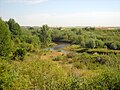
The green route starts at Düren train station, leads through the city center to the market and past the Leopold Hoesch Museum to the Rurufer . Together with the RurUfer cycle path , the path leads along the Rur to Jülich, which is reached after approx. 19 km. On the way there is a connection to the train stations Huchem-Stammeln, Selhausen, Krauthausen, Jülich-Selgersdorf and Jülich Research Center of the Rur Valley Railway . On the route, you can take a detour west to the Inden open-cast lignite mine . This can be circled on a 12 km long loop, with the steel viewing tower Indemann providing a good all-round view. East of the way in Niederzier is "Haus Horn", one of the last surviving residential warehouses from the 17th and 18th centuries. Century. The Niederzier moated castle is also located there, where the municipal administration is located today. In Jülich, the citadel from the Renaissance and the bridgehead park from the Napoleonic period are worth a visit. For the last 8 km to Jülich, the cycle path is also accompanied by the moated castle route . From Jülich city center, the route leads along the Große Rurstraße to the Rurufer and follows it south. After less than two kilometers, the Rur is left after a quarry pond to the west and leads on the outskirts of Kirchberg to the lignite mining area Inden. Here the path leads about two kilometers along the Inde , which has been rerouted due to the opencast mine, before turning north-west to Aldenhoven, which is reached after another two kilometers. The Ludwig Gall House is located in Aldenhoven . Named after the well-known social reformer who was born in Aldenhoven in 1791, the house is one of the oldest buildings in the town. The Bergmannshaus Museum , a mining museum and information center for hard coal and lignite, is also located here.
Aldenhoven - Eschweiler
- Length 24.9 km; Slopes 107 meters in altitude; Gradient 77 meters in altitude.
- Approx. 13% of the route is suitable for road bikes; the rest for touring bikes.
- ADFC difficulty level: easy approx. 75%; medium approx. 25%.
- Traffic load: no to low.

Blausteinsee
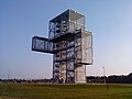
Indemann observation tower

House Palant

Eschweiler old town at night


The cycle path leaves Aldenhoven past the Römerpark leisure and recreational pool, leads past Niedermerz and follows a wooded path to the Blausteinsee, approx. 7 km away . This was created as part of the recultivation of the former lignite opencast mine Zukunft by filling the remaining open pit with surface water and today serves as a recreational area for the surrounding cities. The route leaves the lake after a short time and heads via Fronhoven in an easterly direction back to the Inde, which is reached after 4.5 km. The cycle path runs with it via Lamersdorf and Weisweiler to Eschweiler, approx. 13 km away. There is a rail connection in Weisweiler and Eschweiler. From Lamerdorf you can easily make a detour to the Indemann observation tower . It is only approx. 900 m off the route on the approx. 35 m high, recultivated Goltsteinkuppe waste dump . The 36 m high steel construction offers visitors on three levels a panoramic view of the surrounding area and the Inden opencast mine in the immediate vicinity. Shortly before Weisweiler, the route passes Haus Palant . The present courtyard was built around 1600 in the style of the Dutch Renaissance as a square complex. Today a farm is housed in it. It is therefore not open to the public. In the immediate vicinity is the Weisweiler lignite power station , which can be seen from afar and converts the coal from the Inden opencast mine into electricity. The power plant, which consists of five blocks, has a nominal output of 2097 MW and serves RWE AG as a base load power plant . From the old town of Eschweiler , some remarkable buildings from the 19th century are still preserved today. The main parish church of St. Peter and Paul is located on the market . It houses the 125 centimeter high and 70 kilogram heavy calfskin pietà from the 14th century (around 1360). There are only two other sculptures of this type in Germany.
Eschweiler - Herzogenrath
- Length 39 km; Gradients 377 meters in altitude; Gradient 386 meters in altitude.
- Approx. 45% of the route is suitable for road bikes; the rest for touring bikes.
- ADFC difficulty level: easy approx. 40%; medium approx. 60%.
- Traffic load: no to low.
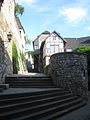
Stolberg old town

Vichtbach in Stolberg

meandering worm near Kohlscheid

View of Herzogenrath


The route leaves Eschweiler, passes the Eschweiler valley station through the Röthgen district , crosses the Eschweiler city forest and reaches Oberstolberg (junction 91, Stolberg) after around 8.6 km. There is a slight ascent of around 5 km with an altitude difference of 140 meters and an incline of 2 to 3%. The old town of Stolberg is located in Oberstolberg . It goes back to the origins of the city and, together with Stolberg Castle, forms the historic city center. With Stolberg, the cycle route has a connection to the railway line to Stolberg main station and from there to Aachen and Cologne as well as to the Euregiobahn . With the Vichtbach , the cycle route now runs north through several Stolberg districts to the junction (87, Stolberg) about three kilometers away. Shortly before the Inde is crossed, and about 400 m after the junction a forest area is reached, through which the route leads to the Forthaus Schwarzenbruch 3 km away. Shortly afterwards, the cycle path crosses the A44 motorway and reaches the town of Verlautenheide in Aachen. The route now continues through Nirm, which belongs to the Eilendorf district, and crosses the A544 motorway with Nirmer Straße . After the motorway, the Haaren district begins , which is crossed. The large roundabout at Europaplatz is reached along the Wurm on the outskirts of the city center. Then the path leads past the Ludwig Forum for International Art and through the spa garden to the old town. The distance from junction 87 to here is around 13 kilometers. The city of Aachen with a number of sights is certainly a cultural highlight of the route. It offers, among other things, the Aachen cathedral, the Aachen town hall, the so-called grass house on the fish market, the Löwenstein house on the market as well as the remains of the Aachen city fortifications. The last 400 m to the market are signposted as a branch route. The way out of the city then leads back to the Lousberg , which is about a kilometer away. The 264 meter high, striking elevation in the north of the city can be bypassed on both sides on the alternatively signposted route. It then continues through meadows and fields to the grinding mill, which is about 3.5 km from the market square. Then the A4 motorway is crossed and after about 3.5 km the junction (9, Würselen) and with it the Wurmtal again reached. The path now follows the course of the Wurm through meadows and small wooded areas in slightly hilly terrain and after about 4.8 km reaches the junction (12, Herzogenrath) via the junction (10, Herzogenrath). From here, Wilhelmstein Castle can be seen on the other bank of the Wurm. The Wurmtal is reached through the edge of Kohlscheid , which belongs to the town of Herzogenrath , and after about 10 km Herzogenrath. The last three kilometers are accompanied by the Düren - Herzogenrath railway line, and the junctions (13, Herzogenrath), (18, Herzogenrath) and (20, Herzogenrath) are passed. In the city is the border and customs castle Burg Rode , built around 1100 . Between 1913 and 1978 the restored castle served as the town hall of Herzogenrath. Today the association “Burg Rode Herzogenrath e. V. ”organizes regular events and offers guided tours.
Herzogenrath - Gillrath
- Length 20.4 km; Gradients 57 meters in altitude; Gradient 93 meters in altitude.
- Approx. 50% of the route is suitable for road bikes; the rest for touring bikes.
- ADFC difficulty level: easy approx. 95%; medium approx. 5%.
- Traffic load: no to low.

Rimburg Castle

Train of the Selfkantbahn


The cycle path leaves Herzogenrath west of the train station, follows the tracks through the Wurmtal in the German-Dutch border area and after approx. 9.5 km reaches the junction (62, Übach-Palenberg). The junctions (22, Herzogenrath), (36, Übach-Palenberg) and (61, Übach-Palenberg) are on the route. Rimburg Castle is located at junction 61 . The well-preserved moated castle dates from the 12th century. It is surrounded by centuries-old oak and maple trees. As it is privately owned, it is not open to the public. The local recreation area of Übach-Palenberg is located near junction 61 , where the foundations of a Roman bathhouse were discovered in 1981. After the restoration, vivid insights into Roman times are offered. Zweibrüggen Castle is located at the last junction of the section . The former moated castle is located in a well-tended garden and shines in its white paint. The palace, built in 1788 in place of the local castle in the classical style, is used today for cultural events. A registry office and various artist studios are also located there. The Wurmtal is now left, which means an ascent of 28 meters in altitude for the cyclist, and the Willy-Dohmen-Park is passed on the right before the next junction (65, Übach-Palenberg) is reached after 2.7 km. The park is located on the site of a former gravel and sand pit and is a particularly worthwhile excursion destination, especially in May, when the rhododendrons are in bloom. The route now continues through agricultural terrain, crossing the towns of Grotenrath and Neuteveren (junction 2, Geilenkirchen) and then walk past the Geilenkirchen NATO airfield to reach the junction (3, Geilenkirchen) in Gillrath after about 8 km . Gillrath is the end point of the Selfkantbahn , which runs on the remainder of the northern branch of the Geilenkirchener Kreisbahnen to Schierwaldenrath as a museum railway with historical rolling stock.
Gillrath - Hillensberg
- Length 37.1 km; Gradients 145 meters in altitude; Gradient 132 meters in altitude.
- Approx. 65% of the route is suitable for road bikes; the rest for touring bikes.
- ADFC difficulty level: easy approx. 97%; medium approx. 3%.
- Traffic load: no to low.

Church in Havert

former Abbey Church Millen


The cycle path now turns west and leads straight through open terrain over the junction (57, Gangelt) to the junction (51, Gangelt) 5.6 km away. The Gangelt leisure center with an outdoor pool, mini golf course and boat pond is on the right. After 2.5 km the junction (52, Gangelt) and the Gangelt wildlife park follow. Here you can see bears, lynxes, wolves, elk and deer, among others. There is also a bird of prey breeding station with daily free flight demonstrations. After driving through a forest, the place Süsterseel (junction 44, Selfkant) is reached after 2.7 km . It belongs to Selfkant , the westernmost municipality in Germany. The route now turns northwards, leads through arable land and two other districts of Selfkant and after 5.1 km reaches a forest area. At its southern edge, the path now runs west to the junction (43, Selfkant) in the Havert district , which is reached after another 4.1 km. Through the still agricultural area, the path leads in a wide curve to the left to the junction (42, Selfkant) in the Schalbruch district 4.1 km away , then further, now turning south, to the Millen district 4.7 km away. The place can look back on a long history. The castle there was the seat of the Lords of Millen until the Lordship of Millen was sold to Dietrich II von Heinsberg in 1282 . From the beginning of the 12th century until 1802 there was a Benedictine monastery in Millen. The church of St. Nikolaus, which still exists today and was already in existence at the time, was used by the monastery as a provost church. The exterior of the church is determined by Romanesque forms, the interior is characterized by the extensive stucco on the walls and ceilings, which essentially dates from the 17th century. Millen Castle has been on the other side of the Rodebach in Dutch territory since the border was drawn by the Congress of Vienna. After another 1.7 km you will reach the junction (41, Selfkant) in the Tüddern district . There is a farming museum here. On approx. 2000 m² the museum shows local history using old tractors, threshing machines and agricultural implements. The cycle path then reaches the stage destination Hillensberg (junction 45, Selfkant) after 7 km via the junction (46, Selfkant) in the Wehr district .
Hillensberg - Voerendaal
- Length 47.9 km; Gradients 42 meters in altitude; Gradient 99 meters in altitude.
- Not suitable for road bikes; Touring bike is recommended.
- ADFC difficulty level: easy approx. 40%; medium approx. 60%.
- Traffic load: no to low.
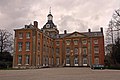
Amstenrade Castle

Brunssummer Heath

Former Headframe of the Oranje-Nassau I colliery

Kasteel Strijthagen

Cortenbach Castle


.JPG)
From Hillensberg the route leads on Dutch territory via the village of Doenrade, where there is a castle that is now used as a hotel, to Oirsbeek (junction 34, NL), which is about 4 km away. Both places belong to the community of Schinnen . The cycle path then runs to Amstenrade with its 17th century castle surrounded by a large park. The square tower still dates from this time. The main building, which has also been preserved, dates from the 18th century and is designed in the Liège classicism style. Then it goes through rural area via the junction (27, NL) to Merkelbeek (junction 28, NL), which belongs to the municipality of Onderbanken , and then in an easterly direction, where after 8.5 km you reach Schinveld (junction 30, NL) becomes. The municipal administration of Ondenbanken is located here. From Schinveld we now head south to the junction (33, NL) and continue past Lake Kattenkoelenvijver through the Schutterspark, a local recreation area and former open-cast lignite mine. The park belongs to the municipality of Brunssum . The route leads past its most famous facility, the NATO headquarters Allied Joint Force Command Brunssum , to the junction (74, NL) (5.7 km). The largest colliery in the Netherlands, the Staatsmijn Hendrik, was located on this site until 1973 . The development of the coal field began in 1913, and in the following decades this largely determined the development of the community. The route now leads through the wooded area of the Brunssumer Heide via the junctions (79, NL), (78, NL) to (48, NL) on the edge of Heerlen . Heerlen has a railway connection to Maastricht and also northwards via Sittard-Geleen and Roermond to Eindhoven and Venlo . The city is connected to Herzogenrath, Aachen and Düren via the Euregiobahn . Mining is also of crucial importance for the development of Heerlen. Around 1900 the first coal was mined at the Oranje-Nassau I colliery . It should also be the last to be shut down in 1974. The route now leads along the eastern edge of the city, crosses the Euregioweg, reaches the municipality of Landgraaf , then heads east along the railway tracks before crossing them and reaches the junction (47, NL) after approx. 5 km. In Landgraaf, too, coal mining began around 1900, which led to the transformation of agriculture into an industrial landscape. The city suffered just as much from the decline of the coal and steel industry in the 1960s as the entire region. The last coal mine Oranje-Nassau II closed in 1971. Landgraaf train station is on the Heerlen - Kerkrade routes ( million line ) and the Euregiobahn to Germany via Herzogenrath. The cycle path runs for approx. 8 km in a southerly direction to the junctions (46, NL) and (43, NL) past the Cranenweyer , which belongs to Kerkrade. Then the path turns west again and leads past the Gaiazoo zoo via the junctions (44, NL), (9, NL) after 4.1 km to Kasteel Strijthagen at the junction (45, NL). The castle (German: Schloss Streithagen) is the only intact aristocratic country estate in the municipality of Landgraaf. It was not until the “Mondo Verde” theme park was set up that the palace again received public attention. Renovated, it now serves as a tourist attraction and as an example of the “Maasland idyll” of past centuries. The cycle route now runs for 11 km through several districts of Landgraaf. The junction (49, NL), (50, NL), (51, NL) is passed before the junction (53, NL) crosses the A76 motorway. The path then runs along the railway tracks and after 1.5 km reaches the stage destination Voerendaal . Close to the route is the Kasteel Cortenbach castle , whose origins go back to a medieval castle. The present castle was built around 1713 as a villa of the Aachen merchant Herman Lamberts. It is privately owned and is not open to the public.
Voerendaal - Berg aan de Maas
- Length 40.3 km; Inclines 115 meters in altitude; Gradient 142 meters in altitude.
- Not suitable for road bikes; Touring bike is recommended.
- ADFC difficulty level: easy approx. 55%; medium approx. 45%.
- Traffic load: no to low.

Alfa brewery

Old town Sittard

Castle Elsloo

Op de Berg in Elsloo


From Voerendaal the route runs approx. 5 km in a westerly direction via the junction (55, NL) to the junction (25, NL), where it again crosses the A76 motorway and also a railway line and reaches the Heerlen settlement of Schuureik, which leads to the Hoensbroek district heard. The Staatsmijn Emma coal mine existed here from 1911 to 1973 . The next junction (24, NL) is then 3.5 km away in Thull, which belongs to Schinnen . This is where the Alfa Bierbrouwerij brewery is located. The path continues 3.3 km past Weiher Muldenplas through Schinnen to the junction (36, NL), where a forest area is reached. The route is sometimes accompanied by the Geleenbeek stream . The cycle route now crosses the forest to the north and on the other side follows the edge of the forest for a while, then continues west to the village of Sweikhuizen, which still belongs to Schinnen. In the village the route branches off to the north again and after about 4 km reaches the junction (38, NL) on the outskirts of Geleen, which belongs to the town of Sittard-Geleen . The city has one of the most important industrial zones in the Netherlands. Large plants from the chemical groups SABIC and DSM are located in Geleen . The NedCar car plant is located in the Born district . The Philips group also has an operation here. There are also several supplier, trading and service companies. The junction is not far from Geleen Oost train station on the Sittard – Herzogenrath railway line . The route now turns south, runs on the outskirts of Geleen, crosses the A76 again and reaches the junction (37, NL) in the Spaubeek district of the municipality of Beek . The route continues via the junctions (22, NL) and (21, NL), where about 7.5 km have been covered since reaching Geleen. The route now leads to the northern edge of Maastricht Aachen Airport before it crosses the A2 motorway and reaches the junction (45, NL) in the Elsloo district of the Stein municipality . Shortly before, the path leads past the park and castle Kasteel Elsloo , where today a hotel and a restaurant are located. It was 7 km from the last junction. Now the cyclist is on the outskirts of Elsloo in front of a bridge over the Julianakanal . This canal accompanies the non-navigable Maas for around 36 kilometers between Maastricht and Maasbracht and is therefore a so-called side canal . It is now 9 km to the stage destination Berg aan de Maas , which still belongs to the Stein municipality, and the junction (50, NL). The route leads north to the junction (33, NL), along the outskirts of Stein, crosses the A67 motorway and shortly afterwards the Julianakanal. On its western bank, the route runs past Steiner Hafen through the district, and shortly afterwards you reach the stage destination Berg aan de Maas .
Berg aan de Maas - Viversel
- Length 86.6 km; Inclines 347 meters in altitude; Slope 348 meters in altitude.
- Not suitable for road bikes; Touring bike is recommended.
- ADFC difficulty level: easy approx. 70%; medium approx. 30%.
- Traffic load: no to low.
Former Sponsorship in Eisden

Restored mine buildings in Eisden

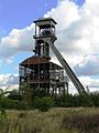
Former Mine shaft in Genk

Albert Canal near Hasselt

Start and finish in Circuit Zolder


In Berg aan de Maas the Meuse and with it the border with Belgium is crossed and the municipality of Maasmechelen is reached. The route now runs in a northerly direction through the district of Meeswiijk roughly parallel to the Maas and follows the long-distance cycle route LF 7 for 3.7 km . The long-distance cycle path is then abandoned in order to follow the banks of the Meuse and the banks of the Grindgoeve for a while, before returning to the long-distance path after 5 km. There the route turns north and reaches 5 kilometers from the node (55, B elgium) in Bicester. It follows the Zuid-Willemsvaart canal . On its eastern bank is the Eisden district , where a coal mine was located until 1987. The route now crosses the Zuid-Willemsvaart and reaches the Koninginnelean via Heufkensweg , which it follows to the north. Further on the eastern outskirts of the city, the path turns west past a lake after 2.4 km, now continues on the northern outskirts of Maasmechelen and after another 4.7 km reaches the junction (50, B). To the north of the route is the Hoge Kempen National Park , the only one in Belgium so far. The Tuinwijk district is crossed on the Kastanjelean before the last two kilometers lead through a forest area and reach the N 763 , where the junction is. The route now follows the N763 for about 5 km to the junction (41, B), turns left here and first runs between the gravel pit and the edge of the forest before it turns into the forest. After crossing the E314 , you are on the edge of a golf course, along which the N744 is reached. The cycle path follows this for a while in the direction of the Wiemesmeer , before turning right. Soon afterwards the junction (30, B) follows. It's about 12 km from the last junction to this point. The further path leads north, crosses the N75 after 1.7 km and reaches the city of Genk . This, too, has developed from a small hamlet to an industrial city due to coal deposits, and it too had to struggle with major structural problems since the 1960s because the mines were closed. The Ford plant , which opened in 1960, and the ArcelorMittal steel plant are now the city's largest employers. The open-air museum Domein Bokrijk with an attached botanical garden and the Europlanetarium are worth seeing in Genk . The route runs on the Sint-Lodewijkstraat through the Groot-Hostart district to the junction (73, B), which is reached after approx. 3.5 km. It is located near the site of the Winterslag colliery , where the Manifesta 9 biennial took place in 2012 , a European exhibition for contemporary art . The further path leads for about 10 km, past the spoil dump of the former colliery, via the junctions (74, B), (79, B), from there west through the forest area of the Holenheide to the junction (305, B) in the Zonhoven municipality . The path now turns south, crosses the village and after approx. 4.5 km reaches the junction (92, B) at the edge of the forest. Here you go right in a westerly direction over the junction (91, B) to the junction (95, B) at the bridge over the Albert Canal , which you reach after approx. 8 km. The Albert Canal connects the two cities of Liège and Antwerp as an artificial waterway . The route is now in the municipality of Hasselt , an old trading town on the former trade route Bruges - Cologne . In the 19th century it was known by the local genever industry. The old town with the St. Quintinus Cathedral and the Grote Markt with beautiful Renaissance half-timbered houses are well worth seeing . The city lies on the Liège - Antwerp railway line and can be reached with the Euregio ticket . After the bridge, the route turns west, crosses the Demer river twice , before returning to the Albert Canal after approx. 5.5 km at the junction (94, B). The canal is crossed again and the junction (316, B) on the N72 is reached after about 6.5 km through a lake area. The route follows the N72 for about half a kilometer to the northwest, before turning into a forest area in the southwest and returning to the Albert Canal via the village of Boldenberg after 6 km at the junction (303, B). Along the canal it is now approx. 2 km to the stage destination in the village of Viversel , which belongs to the municipality of Heusden-Zolder . The period of hard coal mining in the municipality lasted from 1923 to 1992. It housed the last mine in the Benelux countries. Today the winding tower and some large buildings are under monument protection. The overburden dump reached a height of 155 m above sea level and was bought and renatured by the Belgian state in 1997. Right of the route the circuit Zolder Circuit , where in 1973 and 1984, the Belgian Grand Prix of Formula 1 was held. Today it is mainly used for national touring and sports car races.
Viversel - Beringen
- Length 35 km; Gradients 149 meters in altitude; Gradient 157 meters in altitude.
- Not suitable for road bikes; Touring bike is recommended.
- ADFC difficulty level: easy.
- Traffic load: no to low.
The green route continues along the Albert Canal, passes under the E314 motorway and after approx. 1.5 km reaches the junction (304, B) at the former coal port. The route now leads in a north-easterly direction away from the Albert Canal via a cycle path through meadows and wooded areas to the community of Heusden-Zolder . The railway line is crossed in the village before the junction (311, B) at the former colliery site is reached after approx. 8 km. It then continues past the junction (307, B) and the renatured spoil dump of the colliery into a forest area, where the route turns south again at the visitor center of the nature park and after about 8 km reaches the junction (310, B). From now on, the route leads north again into a wooded area, where the route then turns west and runs between the districts of Beringen through meadows and small wooded areas until the junction (341, B) is reached after approx. 8 km. After another 4 km past a former spoil dump and after crossing the railway line, it goes through the outskirts to the junction (345, B) and again to the Albert Canal. After crossing the canal, the route continues southwest towards the junction (330, B). Then the green route ends after crossing the E313 motorway at Lake Paalse Plas after approx. 7.5 km.
Connecting cycle paths
- The 524 km long moated castle route connects more than 130 castles on the edge of the Eifel and in the Cologne Bay . It crosses the green route in Aachen, Stolberg, Aldenhoven, Jülich and Düren.
- The 180 km long RurUfer cycle path leads from the source of the Rur in the Belgian Ardennes to its confluence with the Meuse in Roermond, the Netherlands . It runs together with the green route between Düren and Jülich (approx. 16 km), partly between Kreuzau and Düren and between Niederzier-Krauthausen and Jülich (approx. 7 km).
- The German Football Route NRW runs 550 kilometers across North Rhine-Westphalia. So far, it is the only adventure cycle path in North Rhine-Westphalia that has been laid out under a popular, cross-state theme. The "legend route of German football" opens up next to football cult locations such as the Veltins-Arena in Gelsenkirchen or the Borusseum in Dortmund's Westfalenstadion also the tourist highlights in NRW. It is connected to the green route in Düren and Aachen.
- The two-country route (2LR for short) meanders 270 km between Aachen and Nijmegen through the country on the Maas and Lower Rhine. As a “route with many faces”, the 2LR offers a mix of nature and culture. It crosses the green route in Aachen and runs approx. 32 km with it from Herzogenrath. After that, the two routes meet several times before they finally separate near Großwehrhagen .
- The 480 km long Kaiser Route runs from Aachen to Paderborn and is named after Emperor Charlemagne , who resided in Aachen. The route is based on the presumed route that the imperial army took in 775 on its crusade into the Saxon territory . It crosses the green route in Aachen and Düren.
- The 1045 km long D-Route 4 ( Mittelland Route ) leads from Aachen via Bonn , Siegen , Erfurt , Jena and Chemnitz to Zittau .
- The 733 km long D-Route 7 ( pilgrim route ) leads from Aachen via Cologne , Düsseldorf , Duisburg , Münster , Osnabrück , Bremen and Hamburg to Flensburg .
- The intersection systems in the Netherlands and Belgium are used by the green route.
- At Maasmechelen, the 220 km long Maas route crosses , which connects Maastricht in the south with Arnhem in the north along the Maas .
Rail connection
There are rail connections along the entire green route (see also info box ). In detail, the Stolberg , Eschweiler and Langerwehe stations can be used on the railway line between Düren and Aachen . Jülich can be reached via the Rur Valley Railway from Düren. The Herzogenrath train station is located near railroad tracks Aachen-Mönchengladbach and Stolberg-Herzogenrath and a train station is Euregiobahn over which one to Eygelshoven will get a district of Kerkrade, Landgraaf and armies and from there to Sittard-Geleen. Genk and Hasselt are on the IC route Genk - Brussels - Ghent . From Hasselt there is a train connection via Liège to Cologne. From Beringen in the direction of Germany, the route via Hasselt is ideal.
Landscape, culture and sights
The 80 by 30 kilometer area, which extends from Düren in Germany via Heerlen in the Dutch province of Limburg to Beringen in Belgium, was once one of the largest coal mining areas in Europe. The relics of mining such as heaps, shafts and residential quarters for miners can still be seen in many places. More than 70 sights in the form of moated castles and national parks, natural and industrial monuments can be found along the winding green route. In the Indeland between Düren and Jülich, for example, a “landscape in motion” can be observed: the valleys of the local open-cast lignite mine are to be gradually flooded into a lake landscape. A suspension bridge leads to the panorama plateau on the Carl Alexander dump. From here you can have a wide view of the region.
The cycle path follows this landscape over the border and thus reaches the Dutch part of the green route. Here, settlements of miners, old castles and museums pass by in rapid succession, and you always come across former collieries. Here are relaxing park landscapes today. One of the oldest and most important hard coal mines in the country with its imposing restored winding towers is located near the Belgian town of Genk. The end of the tour in Belgium is dominated by flora and fauna again: the Japanese Garden in Hasselt, a 1000 pond landscape or hikes over former mining dumps on the way to Beringen provide natural tranquility.
Attractions

Aachen Cathedral, north facade

Aachen City Hall

Grass house Aachen
Ponttor Aachen

Historic center of Kornelimünster
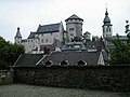
Landmark of Stolberg, the castle
Vichtbach in Oberstolberg
Old town of Stolberg

Rode Castle in Herzogenrath
Mining monument in Heerlen

St. Quintinus Cathedral in Hasselt


.jpg)


- Düren is called "The Gateway to the North Eifel". It is shaped by more than 1300 years of eventful history and today's modern industry. The moated castle Burgau is located in the Burgau Forest on the edge of the Niederau district. In the city there are still remains of the medieval city wall with the thick tower and the Grönjansturm . The most famous museum in town is the Leopold Hoesch Museum. The building, erected in 1905 in neo-baroque style, shows changing exhibitions of contemporary art, including expressionist paintings. Since 1986 there are also works of art of international Biennale PaperArt to see. It cooperates with the neighboring paper museum.
- Jülich was 97% destroyed in an air raid by British bombers in 1944. Today it has one of the largest research institutions in Europe, the Jülich Research Center. The Jülich solar tower is also well known, and the Jülich Solar Institute at the Aachen University of Applied Sciences played a decisive role in its development as a solar thermal demonstration and test power plant . The city offers the two gates of the medieval city fortifications, the Aachen Gate and the Witches Tower . The citadel from the Renaissance with the Citadel Museum and the bridgehead park from the Napoleonic era are parts of the former Jülich fortress .
- The town of Stolberg is located in the Voreifel in a valley through which the Vichtbach flows. Stolberg's early industrialization brought pollution to the people in and around the city through sulfuric acid, slag and heavy metals. As part of the environmental protection program, numerous heaps were rehabilitated as secondary heavy metal emitters and have been renatured for local recreation or recultivated as commercial space. The old town of Stolberg goes back to the origins of the city and, together with Stolberg Castle, forms the historical city center. Over a hundred buildings are listed , and this is also where the city's oldest copper yards are located . The Museum Zinkhütter Hof documents the industrial history of Stolberg in a special way. The facility, originally built as a glassworks in the 1830s and operated until the 1850s, is a well-preserved ensemble of production hall, workers' apartments and administration villa from the early phase of German industrialization. Today the permanent exhibition shows the history of the materials brass and zinc and zinc smelting in the Eschweiler-Stolberg area in addition to the Aachen needle production . The timeline ranges from Roman times ( Hemmoorer bucket ) through the copper masters to structural change in the 19th century. In addition to the permanent exhibitions, there are changing special exhibitions of the fine arts and various topics from the history of technology.
-
Aachen is located in the border triangle of Germany, Belgium and the Netherlands in the center of the Euregio Meuse-Rhine in a valley basin that opens to the northeast, in which the Wurm tributaries collect and flow to the Rur . The urban area is therefore in the catchment area of the Meuse , directly on the northern edge of the slate mountains on the left bank of the Rhine ( Eifel ), about 30 km north of the High Fens . Culturally, it is one of the highlights of the route with its numerous sights. The most famous sights are:
- The Aachen Cathedral was originally built as the palace chapel of Charlemagne built and is the landmark of the city. The ensemble of Cathedral and Cathedral Treasury was in 1978 the first German cultural monument and second world cultural monument World Heritage List of UNESCO added.
- The Gothic Aachen City Hall was built on the foundation walls of the palace auditorium of the Carolingian imperial palace in the 14th century. The coronation hall is on the first floor. Five frescoes by the Aachen artist Alfred Rethel decorate the walls. They show legendary scenes from the life of Charlemagne. On the ground floor, richly furnished rooms testify to the splendor of the free imperial city in the 17th and 18th centuries, when the town hall was converted into a baroque city palace. In 2008 and 2009 almost all of the town hall's premises were opened to the public.
- The so-called grass house is located on the fish market, the facade of which comes from the oldest town hall in the city and dates back to 1267.
- The Löwenstein house on the market was built around the same time as the Aachen town hall and was probably completed in 1345. Along with the cathedral and town hall, it is one of the few Gothic buildings that survived the great city fire of 1656.
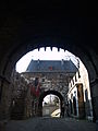
- Numerous remnants still bear witness to the Aachen city fortifications , which consisted of two wall rings and numerous towers . Two of the former eleven mighty city gates have been preserved. The Ponttor at the end of Pontstrasse is one of the few remaining medieval double gates in the Rhineland. The Marschiertor at the end of Franzstraße dates from 1257 and is one of the largest still preserved city gates in Western Europe.
- The border and customs castle Rode, built around 1100, is located in Herzogenrath. Between 1913 and 1978 the restored castle served as the town hall of Herzogenrath. Today the association “Burg Rode Herzogenrath e. V. ”organizes regular events and offers guided tours. In the Wurmtal, southwest of Herzogenrath, there was the oldest documented coal mining for Central Europe; it was first reported in 1113. Centuries of mining have shaped the northern district of Aachen and thus also the city of Herzogenrath. The striking dump landscape has become a landmark that can be seen from afar.
- In Gangelt , the historic city center with its city wall and the castle are worth seeing.
- In Brunssum there are mainly buildings from the 20th century that are well worth seeing, including completely preserved miners' settlements typical of the region. There are also a number of parks:
- Vijverpark : In the immediate vicinity of the city center, a park has been created around the name of the pond (nl. Vijver ) from the remains of a former lignite mine . It is used for local recreation.
- Schutterspark : Also emerged from a former open-cast mine on the banks of the Rodebeeks, the Schutterspark and the adjacent forest and green areas accompany the stream of the Rodebeek as a recreational area and thus separate the industrial areas in the east of Brunssum from the residential areas.
- Brunssumerheide : The Brunssumerheide with typical Atlantic heather vegetation is partially under nature protection and serves as a local recreation area, at the access of which there are a number of parking spaces. A golf course with 18 holes on the Rimburgerweg as well as the Koffiepool (a pond), an outdoor swimming pool and a campsite complete the tourist offer.
- There are a number of museums in Heerlen :
- The thermal baths , which were built around 120 AD, date from Roman times and were discovered in 1940 and partially excavated and reconstructed; The Heerlener Thermenmuseum, opened in 1977, was built above the excavation site.
- In the winding tower, which has been preserved as a mining monument, on the site of the former Oranje-Nassau I colliery, there is a mining museum with exhibits on mining in the Mijnstreek .
- The Nederlands Mijnmuseum is housed in a former winding tower (Malakow construction) of the “ Oranje-Nassau I ” colliery . Most of the exhibits come from Dutch mines.
- In Landgraaf there is the 25 hectare Mondo Verde Park around Kasteel Strijthagen (built in 1674, now the venue and museum, can be visited during exhibitions) . Gardens and small buildings from all over the world can be seen in it. This park, located on the slope of a former mine dump, was included in 2004/2005 as “outstanding” in the street of garden art between the Rhine and the Maas .
- The Belgian city of Hasselt is located on the Albert Canal and offers the following sights, among others:
- St. Quintinus Cathedral : It was built in the 15th and 16th centuries on Romanesque foundation walls with a 63 m high west tower, which has a melodious carillon of 47 bells. It has been the cathedral of the Hasselt diocese since 1967.
- Grote Markt: the beautiful is at his Renaissance - timbered house Het Sweert dating from 1659, which is named by the arm with a sword at the front corner of the first floor. Its predecessor had been an inn since 1452. Until 1713 it was a hostel, today it is a pharmacy.
- Onze-Lieve-Vrouwkerk (Church of Our Lady): It was built from 1728 to 1740 in the transition style between Baroque and Classicism . After its destruction in 1944, it was rebuilt by 1952. It houses art treasures such as the high altar from the former Cistercian abbey of Herkenrode near Hasselt.
- Stadhuis (Town Hall): It is a patrician house from 1630 on Groenplaats (or Groen Plein ) north of the Grote Markt.
- Museum Stellingwerff-Waerdenhof : This is the museum for city and local history with the oldest monstrance in the world from 1286.
- In Beringen , Belgium , the “Flemish Mining Museum”, an anchor point on the European Route of Industrial Heritage (ERIH), tells the town's mining history.
Awards
The green route was awarded three stars in 2012 by the General German Bicycle Club ( ADFC ) as the first cross-border bicycle route. After the ADFC certification expired at the end of 2012, no renewed certification was initiated.
literature
- Bikeline bike tour books. Green route: Industrial culture in the countryside between Düren, Aachen, the Dutch park city Limburg and Hasselt in Belgian Flanders 1: 75,000. 1st edition. Esterbauer publishing house, Sigmundsherberg 2013, ISBN 978-3-85000-347-6 .
Web links
- The green route on the NRW cycle route planner
- Green route , PDF file (0.4 MB)
- Green route flora, fauna, winding towers in three countries ( Memento from January 5, 2014 in the Internet Archive )
- Radroutenplaner.nrw.de . Accessed July 2017
Individual evidence
- ↑ a b City region plans new premium cycle path , on aachener-zeitung.de, accessed on June 17, 2019
- ↑ With three stars through the green metropolis , on adfc-nrw.de, accessed on June 17, 2019
- ↑ Grünroute is the first cross-border cycle path to receive 3 *** stars from the ADFC , at 100prozentlimburg.wordpress.com, accessed on June 17, 2019
Coordinates: 50 ° 57 ′ 52.2 " N , 5 ° 45 ′ 6.4" E