
Oberstolberg
|
Oberstolberg
City of Stolberg (Rhld.)
Coordinates: 50 ° 46 ′ 2 " N , 6 ° 14 ′ 3" E
|
|
|---|---|
| Height : | 228 m above sea level NHN |
| Residents : | 7509 (2017) |
 The landmark of Oberstolberg, Stolberg Castle high above the old town
|
|
Oberstolberg is a district of Stolberg (Rhld.) In the Aachen city region with around 7,509 inhabitants (as of 2017). Together with Unterstolberg it forms the inner city of Stolberg. The height at Grabenstrasse is 227.5 m above sea level. NHN . The district is traversed by the Vichtbach .
Oberstolberg essentially consists of the historic Stolberg old town and the Vogelsang, the Steinweg pedestrian zone , the area of the former market (today " Willy-Brandt- Platz") and the Hammerberg forest area . Adjacent districts are Unterstolberg in the north and Donnerberg , Duffenter in the east and Münsterbusch in the west . In the direction of Vicht , the companies Dalli and Prym are on Zweifallerstraße. The buildings are dominated by Stolberg Castle .
traffic
Oberstolberg can be reached via the Eschweiler-West exit on the A4 . The L 238 runs in a tunnel through the Jordansberg through the district and ends in Zweifallerstraße.
The Euregiobahn stops at Stolberg-Rathaus and Stolberg-Altstadt are located in Oberstolberg (before 2002: Stolberg-Hammer). The DB train station is Stolberg (Rheinl) Hbf .
Numerous bus lines of the Aachener Verkehrsverbund connect Oberstolberg with the other parts of the city as well as with the neighboring cities.
Impressions from Oberstolberg
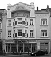
Art Nouveau house

Rathausstrasse with bank branches
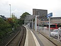
Euregiobahn stop Stolberg-Rathaus

Euregiobahn stop Stolberg-Altstadt

historical old town development on the Vichtbach

Castle with Untertor and the cath. St. Lucia Church


Buildings on Kaiserplatz
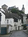
View of the castle

Old and (left) new town hall
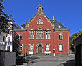
Former district court

Former Goethe high school


Web links
Individual evidence
- ↑ Sonja Essers: More births, but fewer inhabitants in Stolberg. In: Stolberger Zeitung. Retrieved February 2, 2019 .
_COA.svg)
Atsch | Birch Walk (OT) | Breinig | Breinigerberg | Büsbach | Buschhausen (OT) | Diepenlinchen (OT) | Donnerberg | Dorff | Duffenter (OT) | Finsterau (OT) | Fleuth (OT) | Gressenich | Hamm (OT) | Kohlbusch (OT) | Krewinkel (OT) | Liester (OT) | Mausbach | Münsterau (OT) | Münsterbusch | Oberstolberg (with the old town of Stolberg ) | Schevenhütte | Steinfurt (OT) | Unterstolberg | Velau (OT) | Venwegen | Vicht | Vicht-Breinigerberg | Werth | Doubt