Donnerberg (district)
|
Donnerberg
City of Stolberg (Rhld.)
Coordinates: 50 ° 46 ′ 48 ″ N , 6 ° 14 ′ 20 ″ E
|
|
|---|---|
| Height : | 287 m above sea level NHN |
| Residents : | 5602 (2017) |
| Incorporation : | January 1, 1935 |
|
View from Fettberg to Unterstolberg and Donnerberg (in the background) with the transmitter
|
|
Donnerberg is a north-eastern district of Stolberg (Rhld.) In the Aachen city region with around 5,600 inhabitants. It got its name from the ridge called Donnerberg , which borders the Vichttal in the east and at its highest point is 287.3 m above sea level. NHN measures. Until the municipal reorganization in 1972, it was the highest point in Stolberg.
history
The area of today's district belonged to Eschweiler at least since the 18th century . At the official census on December 1, 1905, Donnerberg / Duffenter with 1,471 inhabitants was one of the five districts, along with city center / Röthgen, Bergrath, Röhe and Pump-Stich / Aue. On October 6, 1907, the new building of the Rectorate Church of St. Joseph was inaugurated and consecrated on July 22, 1917. At the official census on October 1, 1910, Donnerberg was one of the six Catholic parishes in Eschweiler: 1,473 people lived here (1,422 Roman Catholic and 51 Protestant denominations). Since the mayor of Eschweiler protested in 1925 against the inclusion of the Donnerberg parish of St. Josef in the newly established Stolberg deanery , it was only added on January 1, 1935 after the district was incorporated into Stolberg.
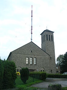
Donnerberg was badly damaged in World War II. The church of St. Josef had to be rebuilt after the war, the foundation stone was only laid on July 26, 1953. Consecrated the new church was on January 20, 1954. Refugees and displaced persons began in the late 1940s with the construction of Donnersberger settlement.
Facilities

The Westdeutsche Rundfunk WDR has been operating a broadcasting system for MW on a large open space next to the church since 1951 , which today broadcasts FM and television. In 1993 the transmission mast was replaced by a 231 m high, guyed steel truss mast with a cross section of 176 cm.
There is a kindergarten and a primary school on Höhenstraße, the main street of the village. The parish runs a third world shop. The Kraków sports field with tennis courts and riding facilities are located by the dry pond. The Eschweiler Stadtwald begins immediately behind the northeastern city limits, while the Donnerberg barracks are located in the northwest .
societies
- Carnival association De Wenkbülle (= The Windbags ) Donnerberg eV 1952
- Male singing association of the Donnerberg settler community 1967 eV
- Trumpet player Donnerberg
- St. Michael Rifle Brotherhood 1881 Donnerberg
- TSV Donnerberg e. V. (football club)
- Cultural Association City Starlights e.V.
Web links
Individual evidence
- ↑ Sonja Essers: More births, but fewer inhabitants in Stolberg. In: Stolberger Zeitung. Retrieved February 2, 2019 .
- ^ Donnerberg - Topographical Map 1: 2000. In: TIM-online (Topographical Information Management). District government of Cologne , accessed on April 22, 2016 .


