
Selfkant
| coat of arms | Germany map | |
|---|---|---|

|
Coordinates: 51 ° 1 ' N , 5 ° 55' E |
|
| Basic data | ||
| State : | North Rhine-Westphalia | |
| Administrative region : | Cologne | |
| Circle : | Heinsberg | |
| Height : | 69 m above sea level NHN | |
| Area : | 42.09 km 2 | |
| Residents: | 10,137 (Dec. 31, 2019) | |
| Population density : | 241 inhabitants per km 2 | |
| Postal code : | 52538 | |
| Primaries : | 02456, Saeffelen 02455 | |
| License plate : | HS, ERK, GK | |
| Community key : | 05 3 70 024 | |
| LOCODE : | DE SKT | |
| NUTS : | DEA29 | |
| Community structure: | 16 districts | |
| Address of the municipal administration: |
Am Rathaus 13 52538 Selfkant |
|
| Website : | ||
| Mayor : | Herbert Corsten (independent) | |
| Location of the municipality Selfkant in the district of Heinsberg | ||
  |
||

The Selfkant ( Limburgisch Zelfkantj ) is the westernmost municipality in Germany . It is located at 5 ° 55 'east longitude in North Rhine-Westphalia Heinsberg district . She is a member of the Zipfelbund , an association of the four municipalities located in the respective main direction on the outermost edge of Germany.
geography
Geographical location

The municipality of Selfkant is located in the Selfkant landscape between the Wurm rivers in the east and the Maas in the west. In the southwest, the municipality borders directly on the Dutch city of Sittard .
In the northwest corner of the Isenbruch area is the westernmost point of Germany, which was inaugurated on June 20, 2015 as an adventure space. The idea behind Hartmut Urban was honored on this day. Even before the border shifts after the First World War near Eupen and Malmedy, Isenbruch was considered the westernmost point of the Prussian Rhine province and Germany. An information board on the street refers to the boundary stone 309 B about 60 m away, which is in a hedge.
From 1949 to 1963 the Selfkant was under Dutch order management .
The municipal border with the Netherlands is around 27 km long, the border line with other German municipalities is only 6 km long. The western tip of the municipality of Selfkant extends up to 4.75 km to the Meuse, which forms the border between the Netherlands and Belgium here.
Nature reserves
- Tüdderner Fenn
- Islet
- Hohbruch
- Höngener and Saeffeler Bruch
Neighboring communities
- Gangelt
- Forest damp
- Echt-Susteren (NL)
- Sittard-Geleen (NL)
- Beekdaelen (NL)
The closest major cities are Aachen , Maastricht and Mönchengladbach . The distance to Aachen in the south is about 33 km, to the south-southwest Dutch Maastricht about 27 km and to the east-northeast Mönchengladbach about 42 km.
places
The following table shows the structure of the municipality with the number of inhabitants as of June 30, 2013 (information from the registration office) :
| District | Residents |
|---|---|
| Dieck | 9 |
| Großwehrhagen | 151 |
| Havert | 522 |
| Heilder | 261 |
| Hillensberg | 588 |
| Höngen | 1280 |
| Isenbruch | 325 |
| Kleinwehrhagen | 103 |
| Millen | 320 |
| Millen fraction | 57 |
| Saeffelen | 941 |
| Breakage | 955 |
| stone | 182 |
| Süsterseel | 1640 |
| Tüddern | 2208 |
| Weir | 775
Scherpenseel |
| Selfkant municipality | 10,317 |
history

The most important rule of the Selfkants in the Middle Ages was initially Millen , the seat of the family of the Lords of Millen, which was incorporated into the rule of Heinsberg in 1282 . Finally, in 1499, the Duke of Jülich acquired the rule of Heinsberg and Millen became the seat of a Jülich bailiff. The places Tüddern , Wehr, Süsterseel and Hillensberg belonged to the Born office and from 1709 to the Sittard office .
From 1794 to 1815 the Selfkant belonged to the French canton of Sittard during the coalition wars . After the Congress of Vienna in 1815, the community came to the Prussian Rhine Province . At this time, the border with the neighboring Kingdom of the Netherlands was established and remained in place until shortly after World War II .

After the Second World War, the Netherlands demanded compensation for the war damage. As a bargaining chip should u. a. the occupied Selfkant serve. For this purpose, on April 23, 1949, in accordance with the final declaration of the London Germany Conference of December 23, 1948, parts of the Selfkant were placed under Dutch order management (see map). At the same time, this also meant the loss of the connection between the region and the West German railway network, as the Geilenkirchener Kreisbahnen had to cease operations in Selfkant (cf. train stations in Selfkant ). The mark was replaced by the Dutch guilder, and Dutch became the official language . The picture of Queen Juliana was hung on the wall in the town hall .
In the following time a lot was invested in the now Dutch Selfkant, e.g. B. in the construction of homes and roads. In March 1957, official negotiations between the Federal Republic of Germany and the Netherlands began on the return of all annexed areas . As a result, the N 274 road, which crosses the Selfkant, with overpasses and underpasses, was created without crossing, in order to enable a fast transit connection without border clearance between the Dutch cities of Heerlen and Roermond after the territory was returned .
In the spring of 1960, the Federal Republic of Germany and the Netherlands agreed on a Compensation Treaty, the ratification of which, however, was delayed. It was not until May 1963 that the Dutch parliament finally cleared the way for the treaty. Since midnight on August 1, 1963, the Selfkant, like all other areas annexed by the Netherlands, has been fully part of the Federal Republic again after payment of DM 280 million to the Kingdom of the Netherlands. (This amount corresponds to EUR 554 million, adjusted for inflation.) The old communities Havert, Hillensberg, Höngen, Millen, Süsterseel, Tüddern and Wehr were formed, which together formed the Office Selfkant. Two months later, on October 21, 1963, the first municipal council elections were held under German administration.
As part of the North Rhine-Westphalian territorial reform on July 1, 1969, when the law on the reorganization of communities in the Selfkant district of Geilenkirchen-Heinsberg came into force, the communities Havert, Hillensberg, Höngen, Millen, Saeffelen, Süsterseel, Tüddern and Wehr were merged to form the new community Selfkant.
In 1971 the scouts' annual intercamp took place in Selfkant .
The section of the road between Heerlen and Roermond in Selfkant was handed over to German administration in 2002 because the transit regulation had become obsolete as a result of the Schengen Agreement . The road was then included in the German road network as the L 410 after making some junctions .
politics
City hall and municipal administration are in Tüddern
mayor
- 1969–1984: Paul Heynen, CDU
- 1984–2004: Willi Otten, CDU (full-time from January 1, 1996)
- 2004 – today: Herbert Corsten, WGR 2
Municipal council
Since the local elections on May 25, 2014 , the seats of the municipal council have been distributed as follows:
- CDU : 14 seats (+1)
- SPD : 5 seats (−1)
- FW (PRO Selfkant): 4 seats (± 0)
- FDP : 3 seats (−2)
- GREEN : 2 seats (+2)
Coat of arms and banner

Banners of the community
Municipal coat of arms
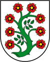
Blazon : "In the silver field an S-shaped curved green branch with eight red roses, whose sepals and clusters are golden." Meaning: The coat of arms is based on an old seal of the former community Millen, which showed a rose branch. The eight flowers represent the former parishes.
Banner: "The banner of the municipality of Selfkant is divided from red to white in the ratio 2: 1: 2: 1: 2 with the coat of arms without a shield in the white banner head."
Town twinning

Partner municipalities of the municipality Selfkant are the other tip municipalities of the Federal Republic of Germany, i.e. the municipalities that are furthest north, east and south. It is about
- around the Schleswig-Holstein List on the island of Sylt,
- around the Saxon town of Görlitz and
- around the Bavarian Oberstdorf .
The first meeting of all mayors of this city partnership on May 9 and 10, 1998 in Selfkant was initiated and organized by the journalist Hartmut Urban. After this meeting, the Zipfelbund was concluded on the occasion of the central celebrations for the Day of German Unity in 1999 in Wiesbaden .
Culture and sights
Museums
- Selfkant Farm Museum in Tüddern
music
There are a large number of music associations in the Selfkant , and the Selfkant plaque is played out annually among the marching band . Since the first display of the Selfkant badge in 2006, the “Selfkant March” has been voiced by all the marching bands at the end of the competition and before the award ceremony. It was specially composed for the competition by the composer PH Wolters from Montfort as a commissioned work. Mayor Herbert Corsten wrote the song that is sung in the trio.
- Instrumental Association St. Cäcilia Tüddern 1912 eV
- Instrumental Association Süsterseel eV
- Music association "St. Gregorius “Saeffelen eV
- Music association "St. Martinus “Schalbruch eV
- March of the 1920s "Edelweiss" Havert eV
- Spielmannszug Saeffelen 1921 eV
- Spielmannszug Wehr eV
- Drummers, Whistlers and Fanfare Corps Höngen eV
- Drummers and Piper Corps “St. Martini “Isenbruch eV
- Drummers and Pfeiferkorps Selfkant-Schalbruch eV
- Drummers and Pfeiferkorps Hillensberg eV
- Drummers and Whistlers Corps "Selfkantia" Süsterseel eV
- Drummers and Pfeiferkorps Millen eV
- Hunting horn blower St. Bavo Grenzland eV
- Men's Choir St. Josef Höngen
Buildings
education
- Secondary school of the Selfkant school association in Gangelt
- Mercator School Selfkant-Gangelt-Geilenkirchen
- Selfkant School Höngen
- Gangelt-Selfkant comprehensive school
- Astrid Lindgren Elementary School
- Catholic Primary School Selfkant II
Personalities
- Wilhelm Cleven (1893–1983), auxiliary bishop in Cologne
- Funny van Dannen (* 1958) from Tüddern, songwriter, writer and painter
- Johannes Klaßen (1922–1994) school principal, co-founder of the Heimatvereinigung Selfkant eV and longstanding chairman of the association, holder of the Federal Cross of Merit and the Rhineland Taler
literature
- [2] Dr. Wolfgang Woelk. Full-time lecturer (Institute for History) Uni Koblenz: The Dutch border corrections 1949-1963 in the politics of the state of North Rhine-Westphalia and their effect on the population of the contract administration areas
- [3] Everyday life "between Mark and Gulden" The Selfkant under Dutch order management 1949 to 1963
- Jakob Cals: History of the church play by Havert . Ed .: Schützenbruderschaft St. Johannes Havert. Geilenkirchen 1989.
- Albert Baeumer and Alfred Bekker: Mercator, Murder and Carrots - Hunting through the Selfkant . Detective novel about the Selfkant as the first German tourist thriller. Ed .: Selfkant-Verlag, 2007.
- Albert Baeumer and Alfred Bekker: Coffee, art and caviar - last exit Selfkant . Detective novel about the Selfkant as the first German art tourism thriller. Ed .: Selfkant-Verlag, 2008.
Web links
- selfkant.de Website of the Selfkant community
- Monuments in the municipality of Selfkant
- [4] Post-war history: When the Netherlands wanted to annex parts of NRW, Rheinische Post, April 2018
- [5] Collective identities in Selfkant 1944/45 –1963
Individual evidence
- ↑ Population of the municipalities of North Rhine-Westphalia on December 31, 2019 - update of the population based on the census of May 9, 2011. State Office for Information and Technology North Rhine-Westphalia (IT.NRW), accessed on June 17, 2020 . ( Help on this )
- ↑ In openstreetmap : [1]
- ↑ Page no longer available , search in web archives:
- ↑ ... the westernmost point is Isenbruch in the district of Heinsberg, in the administrative district of Aachen belonging to the Prussian Rhine Province, under 51 ° 6 'N. Br. And 23 ° 40' E. L. According to Andern, the westernmost point is a mile southwest of the Dutch - Limburg city of Weert , on the Süd-Wilhelms-Canal , at 23 ° 15 'ö. L. - p. 4 in S. Steinhard : Germany and its people: a reading and house book for young and old to promote and stimulate the patriotic spirit and Knowledge , Volume 1, Friedrich Brandstetter, 1856
- ↑ Germany's westernmost boundary stone - Sights worth seeing in Geilenkirchen and the Heinsberg district ( Memento from June 16, 2010 in the Internet Archive )
- ↑ Where Germany ends: The disappeared stone , Mitteldeutsche Zeitung (online) of August 31, 2009; accessed on March 16, 2016
- ↑ https://www.landtag.nrw.de/portal/WWW/Webmaster/GB_II/II.1/Oeffentlichkeitstsarbeit/Informationen.jsp?oid=97971
- ↑ Reiner Burger: To the Netherlands and back, in: FAS No. 1, January 7, 2018, p. 5.
- ↑ Reiner Burger: To the Netherlands and back, in: FAS No. 1, January 7, 2018, p. 5.
- ↑ Reiner Burger: To the Netherlands and back, in: FAS No. 1, January 7, 2018, p. 5.
- ↑ Reiner Burger: To the Netherlands and back, in: FAS No. 1, January 7, 2018, p. 5.
- ↑ Holland Treaty
- ↑ Martin Bünermann: The communities of the first reorganization program in North Rhine-Westphalia . Deutscher Gemeindeverlag, Cologne 1970, p. 101 .
- ↑ Selfkantmarsch , accessed on March 16, 2019

Erkelenz | Gangelt | Geilenkirchen | Heinsberg | Hückelhoven | Selfkant | Übach-Palenberg | Forest damp | Wassenberg | Wegberg
Dieck | Großwehrhagen | Havert | Heilder | Hillensberg | Höngen | Isenbruch | Kleinwehrhagen | Millen | Millen's fraction | Saeffelen | Breakage | Stone | Süsterseel | Tüddern | Weir