
OpenStreetMap
|
|
|
|---|---|
|
|
|
| The Free Wiki World Map | |
| Geographic information system , wiki project to create a free world map. | |
| operator | OpenStreetMap Foundation |
| editorial staff | Members of the OpenStreetMap community |
| user | 6.5 million |
| Registration | only necessary for processing |
| On-line | July 2004 |
| https://www.openstreetmap.org | |
OpenStreetMap ( OSM ) is a free project that collects, structures and stores freely usable geodata in a database for use by everyone ( Open Data ). This data is available under a free license , the Open Database License . The core of the project is therefore an openly accessible database of all the geographic information contributed.
Both free and commercial maps can be created from this data . The maps shown on the project website, created purely from our own data, are examples of this. The data can also be used free of charge in print products, on websites or for applications such as navigation software , without being restricted by restrictive licenses . According to the license, the naming of OpenStreetMap as the data source and the submission of the change to the data set under the same license is required.
history
.jpg)
The OpenStreetMap project was launched in July 2004 in London by Steve Coast . In the meantime, volunteers from many countries are working on both the development of the software and the collection and processing of spatial data. In March 2006 the infrastructure was so well developed that the first larger areas could be recorded. In July 2006 around 2500 users were registered who at that time had added over nine million waypoints to the OpenStreetMap database. A year later, the number of users had almost quadrupled and the amount of data increased tenfold.
In April 2006 the OpenStreetMap Foundation was founded. It collects donations and is a decision-making body and responsibility for the project. The OpenStreetMap Foundation is an international non-profit organization . Its goals are to create, distribute and enlarge a geographic database and to make it available for general use.
The import of the TIGER database was completed in January 2008 (see also section Import ). The state-recorded TIGER data provide a basic coverage of the USA that needs to be further improved by users, since areas such as sports fields are still missing and the data is partly out of date.
In March 2009 over 100,000 users had registered worldwide. In mid-January 2013 it was reported that the one million user mark had been exceeded, doubling the number of users over the past 14 months.
In December 2015 there were 2.3 million users, 4.9 billion GPS points, 3.1 billion nodes, 210 million routes and 3.1 million relations.
OSM received the FSF Award 2018 from the Free Software Foundation .
Community
The geodata is usually maintained by the individual users on their own: Local knowledge and data collected in the field are entered with a suitable processing tool or existing data is supplemented and refined.
In the case of so-called mapping parties, a previously defined area is recorded together and entered in the database. This makes work easier, especially for beginners in regions that are still sparsely covered.
As in other open source projects, regular meetings are held in many regions.
In 2007 an annual OpenStreetMap conference, called State of the Map , was launched, which has since found numerous local branches, e. B. SotM-Latam, SotM-US, SotM-Japan and SotM-Scotland. The OpenStreetMap has its own track at the GIS conference FOSSGIS .
Two thirds of the users are from Europe. Most of the active users are from Germany, the US, France, Russia, the UK, Italy and Poland; Austria has the most users in relation to the population.

Areas of application
The website shows only a small part of the possibilities of OpenStreetMap. The OpenStreetMap raw data are available for download and are freely accessible for the development of further applications. Numerous other services and special applications - so-called mashups - are based on the OpenStreetMap data . A comprehensive overview of such applications can be found in the OpenStreetMap Wiki.
The level of detail of the OSM data differs greatly from region to region and practically only depends on the effort made by the contributors. The depth of detail of the system itself is theoretically unlimited.
Map display
- Map examples
Cycle map with cycle paths / long-distance cycle paths, contour lines and route calculation (OpenRouteService.org)

Sea map (OpenSeaMap)

Topographic map from OpenStreetMap and SRTM data

Computer program Marble with OpenStreetMap view


The data from OpenStreetMap can not only be used to generate road maps for drivers. Depending on what data is available and how it is transferred to the map display, cycling and hiking maps can also be created, whereby many marked hiking routes are shown in the database and can be highlighted on graphic maps. Maps for ski areas, maps showing public transport and the OpenSeaMap portal for shipping and water sports are also available .
The maps generated from the geodata are initially two-dimensional, that is, they do not contain a relief representation as in topographic maps (for example, contour lines ). However, there are tools for converting and displaying the SRTM data to be obtained from external sources . This can be used to add contour lines or hillshades .
Projects like OpenLayers or Leaflet make it possible to integrate OSM-based interactive maps into websites. The OSM plug-in for WordPress integrates the OpenStreetMap data in blogs to link posts and photos with geodata and visualize the corresponding relationships. There are also other projects such as the virtual globe Marble for Qt 4 or the Kosmos renderer for Windows .
OpenStreetMap maps or their derivatives are used by larger websites: foursquare , craigslist or pinterest . Yahoo uses OpenStreetMap data for its Flickr offering for various cities, such as Baghdad, Beijing, Kabul, Sydney and Tokyo.
The city network maps of the Rhein-Ruhr transport association are based on OSM maps.
OpenStreetMap data can be used on navigation systems and in navigation software for route guidance.
Route calculation using OpenStreetMap data is fully developed in terms of software and, with regard to the database, can already be used in most parts of the world. In terms of currency, OSM data can be far superior to even commercial material, as changes can be made by anyone and are immediately available. The road network itself is extensively covered, but outside of cities and towns, detailed information such as house numbers, one-way streets and turning restrictions at intersections is still incomplete, as this information cannot be seen on aerial photographs and can only be determined from the street.
Web-based routing services
- Open Source Routing Machine (OSRM) under the BSD license
- GraphHopper under the Apache license
- OpenRouteService of the University of Heidelberg, which is only partially open source
- YourNavigation is developed under the BSD license
With the web interface, route planning is possible on foot, by bike or by car, whereby you can choose between two different engines. Mapquest is available to every road user.
Naviki uses OSM maps for bicycle route planning . In the calculation, bike-friendly routes are preferred. There is also a version for smartphones , which can be used across Europe.
Street navigation with OsmAnd

Examples of this are Roadee and Skobbler for the iPhone, WeTravel and GpsMid for Java- enabled cell phones, Traveling Salesman for Nettops and AndNav2 for Android or TrackMyJourney, which in turn uses one of the aforementioned web-based routing engines.
The open source project OsmAnd (OpenStreetMap Automated Navigation Directions) offers several online navigation services as well as offline navigation for cars, bicycles and pedestrians; Navigating along a given GPX track is also possible.
A Qt-based solution called MoNav, like OSRM, uses the contraction hierarchy algorithm as the basis for fast route calculation. MoNav can be created for different Windows Mobile versions as well as for all systems with Qt support.
A number of commercial navigation apps such as MagicEarth , MapFactor Navigator or Maps.me use maps from OpenStreetMap, at least in their free version, and can use it (depending on the degree of coverage of the road in the OSM database) to output not only turning instructions, but also details such as speed limits or lane recommendations .
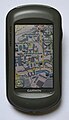
Garmin Oregon 550 with OpenStreetMap map

Bike navigation with Gosmore and OSM data

The mkgmap software makes it possible to create map material from OSM data that can be used on navigation devices from Garmin . This enables the creation of up-to-date, detailed maps that can also be routed. Some community members offer such maps for Garmin devices ready-to-use for download.
Newer Garmin devices can also display maps as raster data in KMZ format or in the proprietary Birdseye format. The size of KMZ maps is very limited in terms of the number of tiles and zoom levels that can be used. However, there are now software and firmware patches to use the protected Birdseye format for self-created maps from OSM tiles.
mkgmap was developed by reverse engineering on the basis of a (quite old) Garmin format. For navigation devices from other manufacturers, it is difficult or impossible to use OpenStreetMap maps, as no converters have been developed for their native file formats. In some cases, however, separate programs such as Navit or Gosmore can be installed on it or on notebooks.
Humanitarian aid
Emergency services in disaster areas need the latest maps for rescue and supply trips. Depending on the system, OpenStreetMap can create and maintain suitable material at short notice and also make this data available for retrieval via the Internet. For the first time during the earthquake in Haiti in 2010 , the current geodata of the affected area began to be entered in OpenStreetMap after just a few hours. Commercial operators also made current high-resolution satellite images available so that road sections that were destroyed and the location of collapsed buildings could also be recorded on the online map. These up-to-the-minute maps made it much easier for the on-site assistants to work specifically.
On the basis of the experience gained with this crisis mapping , the Humanitarian OpenStreetMap Team (HOT) was founded, which coordinates the networked mapping in the event of disasters in order to be able to provide map material as quickly as possible.
Map creation


Every user who wants to work on the card must first register with a verified e-mail address. Registration is free and is intended to prevent spam and vandalism. In addition, a communication channel is available to every other user.
Read-only access to the database is also possible without a user login.
Raw data acquisition

The maps are created from raw data that are either collected by volunteers themselves or made available to the project from other sources.
Even collected raw data is recorded with a GPS receiver , for example , while roads, paths or rivers are being walked or driven. However, data collection does not rely on GPS. For example, it is possible to print out the existing map as a field paper to record buildings, house numbers etc. and enter the missing data on site so that they can then be entered into the database at the desk. Alternatively, using OpenStreetMap apps, data can be collected and entered on the map in a single work step.
In addition, the project has high-resolution aerial photographs as well as (regionally limited) certain map materials available, from which roads and areas can (and may) be drawn with greater precision than from a GPS track, which is subject to the system-related inaccuracies.
The transfer of data from other maps to OpenStreetMap without express permission is prohibited due to the rights to geographic information . To protect these rights, commercial cards are deliberately made with insignificant errors, for example Trap Streets , which make copies verifiable. It is therefore customary to indicate the source of any change or addition to the map. The community pays great attention to compliance with the legal rules and also asks quickly if there are doubts about the data source.
Drawing
On the basis of his raw data, the user draws the geodata, for example streets, buildings or land uses, on the map. For this purpose, the geodata already available in the database for the area to be processed are graphically displayed in the editor as a “map skeleton” made up of points, lines or areas. The user makes his changes directly in this display. Various drawing and selection tools are available for this purpose.
Tagging
Attributes, so-called tags, are assigned to each drawn element . Only the tags reveal whether a certain line represents a dirt road, a railway line, a fence or part of a national border - the drawing tool is the same in all cases. Newly drawn elements must therefore be "tagged". The tags are either typed in by hand or set from a template offered by the editor.
Each tag consists of a key (key) and a value (value) , the relationship is represented in the literature with an equal sign. For example, it is highwaythe key to all types of roads and paths. The value indicates whether it is a motorway ( highway=motorway) or a dirt road ( highway=track). The most important attributes are the object category (for example, a residential street is highway=residentialspecified as) and (if given) the name ( name=Schillerstraße), which is important for the search function.
Areas are recorded as closed paths that define the outlines. Then, for example, the outline of an industrial area is landuse=industrialassigned the tag .
The tags can in principle be freely invented; For optimal evaluability, however, one adheres to the generally recognized forms, as they are listed and explained in the OpenStreetMap Wiki, the documentation of the project. In addition, new tagging structures are continuously proposed and discussed there.
The number of tags per element is theoretically unlimited, so that building=yesa wealth of additional information can be mapped via the purely physical properties (e.g. for a building). The building can be characterized as a church, school or hotel; Address data, opening times or a link to the website can be encoded. In the case of roads, restrictions (e.g. speed limits) or lanes can be mapped in sections using tagging; in the case of petrol stations, the types of fuel offered. It is this detailed tagging of the metadata that makes the real value of the project. On the basis of this data, a navigation system could, for example, request the output of all mailboxes that are a maximum of 30 meters away from the route and that can be reached before emptying.
So-called relations link elements to form larger entities. This enables bus routes to be recorded, for example: a bus route relation contains all road sections traveled and the stops. Hiking trails are mapped in a similar way, which can then be shown in hiking maps.
Since a single card would be overloaded with all this data and would be unusable, there are numerous different card editions, each using relevant data from the database. But the deliberately simple standard map on the OpenStreetMap website also makes it possible to use the object query tool to display the complete tagging of any element from the database. A region-specific query (such as the output of all registered filling stations that offer a certain type of fuel) is possible with the Overpass Turbo tool .
Mapping
The separation of the steps of raw data acquisition, drawing and tagging makes it possible to work on the project without your own GPS receiver by adding and refining the available data based on your local knowledge or your own research. An important task here is adding and editing points of interest (POI), such as house numbers , bus stops , taxi stands, schools or telephone booths . With the appropriate local knowledge of the processor, the database is expanded and errors are corrected. This collaborative process of map creation is known in the jargon as "mapping".
software
There are various software solutions (editors) for entering and editing the geodata, but their basic concepts are largely the same. A distinction is made between online and offline editors:
- Online editors work directly in the user's web browser. This requires a permanent internet connection, “in the field” this technology can only be used to a limited extent. These editors offer a good introduction to OpenStreetMap with a rather simple interface.
- Offline editors are programs installed on the user's computer. After downloading the existing data once, they can also be used without an Internet connection. The edited data is first saved locally and then downloaded to the server as a change record.
Access to OpenStreetMap data for editing is via the OpenStreetMap API, currently version 0.6.
If GPS tracks are used as raw data , they can also be uploaded to the server for display in an online editor. Appropriately licensed aerial photographs or other geo-referenced images can be placed under the geodata shown. Based on this data, the user can create points (nodes) with a click of the mouse , which join together to form lines (ways) . Points and lines can then be moved, supplemented and refined; Comfortable editors offer numerous tools for this.
- JOSM
- Offline editor based on Java , executable on numerous desktop platforms. User interface available in numerous languages, including German of course. JOSM currently offers the largest range of functions, can optionally be expanded with over 100 plugins (as of May 2015) and was used in 2013 for over 50% of all processing.
- iD
- Online editor, embedded as a standard tool on the Openstreetmap.org website since May 7, 2013. It is based on JavaScript and should be particularly simple and beginner-friendly.
- Merkaartor
- Offline editor, based on Qt .
- StreetComplete
- Simple Android app that asks the user simple questions about objects in the vicinity. It is especially intended for beginners without OpenStreetMap knowledge and only allows editing of the elements that it asks for.
- Osmosis
- Offline editor, command line application with which processing chains can be put together and larger operations can be carried out.
- Vespucci
- A comprehensive mobile editor for Android smartphones.
- Potlatch
- Online editor based on Adobe Flash . Edits with potlatch contributed approx. 30% to the database until 2012. Was replaced as the standard editor by iD , but is still available.
- iLOE
- The first OpenStreetMap editor for the iPhone. It allows you to add and change "nodes" while on the move.
- OSM2Go
- Mobile OSM editor for Nokia Internet tablets under Maemo with GPS , touchscreen and pen support, based on GTK + / C and also runs on desktop Unix

Potlatch 2 with OSM raw data

JOSM editor
Merkaartor editor

StreetComplete


technology
server
The main server and infrastructure of the project belong to the OpenStreetMap Foundation and are currently operated in London at University College . The servers consist of a powerful database server, a front-end server for the website, three application servers for the programming interface (API) and a tile rendering server that calculates the map in the form of tile graphics . There are also a few other weaker servers for additional services, such as the OpenStreetMap Wiki, the code repository and the search function.
The OpenStreetMap database server uses a PostgreSQL database. The website and the API are largely programmed in Ruby on Rails . The database contains the geodata, i.e. lines, points and areas provided with additional information (attributes, tags ). These vector data are the main product of the project. A pixel graphics card ( PNG ) is also rendered from it. This is generated with the help of a separate PostGIS database and the Mapnik renderer, the data of which is updated when the raw data is changed. In order to reduce the rendering load, only those areas of the map are rendered that were actually viewed, for which the Apache module mod_tile was specially written. The Mapnik renderer offers the standard view of OpenStreetMap, the render style used for this is taken care of by professional cartographers .
In addition to the Foundation's servers, there are a number of other computers that are operated independently and offer important services for the project.
Data formats

GPS raw data (tracks) can be uploaded to the OpenStreetMap server in the common GPX exchange format and thus made available to the general public. Conversion programs such as GPSBabel , the OSM filter developed by the OpenStreetMap project and several other special auxiliary programs make it possible to convert raw data in other formats such as NMEA into GPX format.
All data are collected in the WGS84 format with longitude and latitude and are mostly displayed in Mercator projection .
Output formats
The finished map data is exchanged in .osm format, an XML format whose syntax corresponds to the outputs of the OpenStreetMap API. Copies of the entire database are available updated weekly; in OSM jargon this complete edition is referred to as “planet file” or “planet” for short. “The Planet” has (as of 2019) a size of 83 gigabytes compressed by bzip2 . There are also daily and hourly updates as well as excerpts for individual countries.
In addition, the vector data are also made available on the Geofabrik website as shapefiles (* .shp / shx / dbf ) that can be used in many geographic information systems (GIS). Alternative APIs for downloading and filtering the data such as XAPI and Overpass API are also provided by third parties.
Data sources
OpenStreetMap's data sources are:
- GPS tracks: electronic records of the routes traveled as a reference for drawing in OSM routes
- Aerial photographs and maps provided by the respective owner for manual signing
- Local knowledge of the contributors (e.g. for opening times of shops)
- External collections of geospatial data that can and may be imported “in one piece” into the OSM database
GPS tracks

GPS tracks , obtained with a GPS receiver by recording a route that has been walked or driven, are partly incidental to other activities, but are also deliberately created by volunteers for mapping. In the early days of the OSM, they were the most important source for the map framework made up of paths and streets and, where aerial photographs or other map material are available, still serve as a reference for its precise alignment (lateral offset).
GPS navigation devices or special GPS data loggers are preferably suitable for recording the GPS tracks because of their good measurement accuracy, but cell phones with GPS functions can also be used. Some navigation devices require special software for this.
Due to the limited accuracy of individual GPS tracks , it is best to work with several GPS tracks of the same route, recorded at different times. With OpenStreetMap, users can upload their own traces and make them available to other users; the function for uploading and downloading GPS tracks is already integrated in many editors.
The road courses obtained then have to be provided with their metadata such as road type and name . ( Geo-referenced ) photos, audio recordings, notes and sketches serve as the source .
Aerial photos
Aerial photos are available almost all over the world in different resolutions. They are now the most important source for the geometry of paths and streets and other geographic objects. They are opened in a drawing program (editor) as a background, an exact georeferencing ( e.g. compensation of misalignments or distortions) can then be done using the GPS on the server - Traces are made. The objects are then drawn by hand using the aerial image background. The properties of the objects, for example the assignment to a street class or the type of building, can only be seen to a limited extent from the aerial photograph and are usually supplemented on the basis of local explorations (local knowledge).
- Bing
- On November 23, 2010 it was announced that Microsoft would make the aerial photographs of its map service Bing Maps available for drawing and that OSM founder Steve Coast, as a new Microsoft employee, would coordinate the cooperation between Bing and OSM. On November 30, 2010, Microsoft published a document that defines the conditions under which the aerial photographs may be used for OpenStreetMap.
- Landsat
- The public domain Landsat 7 satellite images are available to OSM. As a rule, the resolution is not sufficient to draw out details such as individual buildings, but streets, bodies of water and the like are recognizable. Services like Bing and Yahoo also show Landsat images in areas for which they do not have detailed aerial images.
Services that are no longer available
- Yahoo
- Yahoo's aerial imagery was allowed to be used for signing from 2006 to 2011. Baghdad, for example, was copied from the Yahoo images because the security situation did not allow them to be recorded on site. Mostly, however, only the slightly better resolved metropolitan areas came into question for marking streets and buildings. On September 13, 2011, Yahoo ended the support of the necessary programming interfaces. The license-compliant signing of Yahoo aerial photos is no longer possible.
- OpenAerialMap
- The OpenAerialMap project responded to the desire to illustrate the OpenStreetMap maps with a world map from free aerial photographs . This service is no longer available since November 2009. A resumption has been announced, but has not yet been implemented.
Regional data sources
- Bavaria
- The Bavarian State Office for Surveying and Geoinformation provided orthophotos of the Upper Palatinate in two-meter resolution for drawing in 2009 in order to gain experience in cooperation with OpenStreetMap as part of a three-month pilot project. The result: in just three months, two person- years of voluntary citizen work were done. Since February 24, 2011, the two-meter aerial photos for all of Bavaria have been approved by the land surveying office.
- GeoImage
- Since October 2010, GeoImage.at has also released aerial photos for all of Austria for drawing on OpenStreetMap. GeoImage.at is extremely accurate and was first offered in a resolution of 1 pixel / meter. Image material with a resolution of 4 pixels / meter (1px / 25cm) has been available since July 2011.
- Aargau
- Since April 2012, high-quality images from 2011 in the Aargau Geographical Information System in 25 cm resolution for the Canton of Aargau (Switzerland) have been allowed.
- Hamburg
- Since 2012, the Free and Hanseatic City of Hamburg has provided the basic geospatial data as well as the official, geocoded aerial images with a resolution of 40 centimeters per pixel within the framework of the Hamburg Transparency Act .
Local knowledge
Even if GPS traces and aerial photos form an important data basis for OpenStreetMap, a lot of useful information can be entered in the OpenStreetMap database even without access to one of these sources. Once a basic structure of paths and streets is available in one place, additional information such as names, house numbers and traffic restrictions can be added. The same applies to important facilities such as shops, churches, letter boxes and so on, which are entered manually relative to the existing network of paths. Places that require revision or where information is missing can be marked on the OpenStreetMap website by anyone without registration.
Various solutions were designed to check the quality of the OpenStreetMap data. Among other things, with the OSM Inspector and keepright, inconsistent data such as unconnected roads, missing intersections or incorrect use of tags can be easily recognized and corrected with local knowledge.
import
Some data were imported directly into the database, some of which are listed here. A complete and current list can be found in the OpenStreetMap wiki.
- In the United States, the TIGER data set is intended to provide a basis. This 1984 road data, published by the United States Department of Statistics, provides very good basic coverage of the United States. Import ended in January 2008.
- The Dutch company AND provided the project with up-to-date road material from across the Netherlands, as well as the main road networks from China and India, in the expectation that the community would improve this material. The import of the Dutch data started on September 5, 2007 and was completed in early October 2007. On February 4, 2008, the data for India was imported.
- Import of data from the local government: For example, street cadastre that were drawn up as part of the introduction of NKF . Examples are the city of Löhne and the municipality of Kirchlengern .
- The Frida project provided free vector data for Osnabrück.
- Many coastlines come from the Prototype Global Shoreline Data (PGS) provided by the National Geospatial Intelligence Agency (NGA), which was obtained from Landsat images.
- For national borders, the data is imported from the CIA World DataBank II (WDB).
- In Austria, data was imported from plan.at.
- Since 2016, Facebook has been mapping areas for OpenStreetMap automatically together with DigitalGlobe.
Automated imports are controversial in the OpenStreetMap community and require careful preparation. Comparisons show in particular that the community in the USA is much smaller (measured by the number of active users or the proportion of objects with multiple versions) than in Germany, for example. This is attributed to the early TIGER import.
List of possible data sources
OpenStreetMap maintains an extensive list of possible data sources, sorted by country and region. It is noted in each case whether these sources have currently only been proposed, checked or approved for use.
Weekly news
The OpenStreetMap community publishes the latest news from the OSM environment in several languages every week
privacy
OpenStreetMap saves freely available geospatial data - for example the location and floor space of a house as well as general information such as the number of floors or address with house number. The storage of personal data (e.g. number or names of residents) is not intended and does not correspond to the project framework. It is common on private property not to record any further details such as lawns or footpaths beyond the building and driveway. However, this cannot be controlled. However, in individual cases this would also be data that can also be seen from aerial photos from other providers and are therefore publicly available anyway.
When editing the OSM data, it is saved which user made the editing and when. Changes can therefore be assigned over the entire duration of the project, and queries from other users can be asked specifically.
External services that use the freely available OSM geospatial data (e.g. route planner) can of course save user data for their part without OpenStreetMap having any influence or access to it.
Cooperation with Wikipedia


Wikipedia and OpenStreetMap have been working together since October 2010.
Map in every location-related article
In every location-related Wikipedia article you will find a link "Map" in the upper right corner. One click opens the OpenStreetMap map and shows the location highlighted with a marker. All Wikipedia articles “nearby” are also marked on the map with a marker. Clicking on a marker opens a window in which a link to the corresponding Wikipedia article is shown, as well as an image from the Wikimedia Commons image database .
World map of all Wikipedia articles
The OpenStreetMap-Wikipedia map shows all georeferenced Wikipedia articles and the associated images worldwide. The further you zoom in, the more markers appear. A click on a marker opens a window in which a link to the corresponding Wikipedia article is shown, as well as an image from the Wikimedia image database “Commons”.
In the world map of all Wikipedia articles, all images can be displayed as miniature images instead of the markers. You can then see around 30 images from the area around the Brandenburg Gate in Berlin, for example the market hall, the Berlin Wall, the American, French and Polish embassies. Each picture links back to the corresponding Wikipedia article.
Map with pictures from Wikimedia Commons
Another map shows all content from Wikimedia Commons, which is provided with geographic coordinates. In addition to the position, the viewing direction is also displayed in photographs, so that, ideally, a certain object can be viewed from several perspectives. For example, you can view the Brandenburg Gate in Berlin from the west or the east, or the Straße des 17. Juni from the Brandenburg Gate. This map is also useful because Wikimedia Commons often contains significantly more content than is included in Wikipedia. In addition, you get a geographical overview, while the content in Wikipedia can be divided into different articles.
Wikipedia context on OSM objects
While the previous examples only use OSM as a background map, the OSM tag provides wikipedia=*the opposite possibility of linking the corresponding Wikipedia article to an OSM object. This is in turn visualized on the maps of the Wikipedia articles, using the WIWOSM service.
Licenses
The data of the OpenStreetMap project were initially licensed under Creative Commons Attribution ShareAlike 2.0 (CC BY-SA 2.0). However, there were some problems associated with this license. For example, in the United States it is not certain that the data could even be protected by this license - which is based solely on copyright. The principle of facts are free could prevent that. A remedy was hoped for from another license that is based not only on copyright law but also, for example, on database legislation, which is why the introduction of a new license was discussed at an early stage.
The OpenStreetMap Foundation has been publishing the database under the Open Database License (ODbL) since September 2012 . Approval for licensing under the ODbL is made when the contributor accepts the so-called Contributor Terms . Since May 2010 this has been a prerequisite for creating a user account on the OpenStreetMap website. Account owners who were registered prior to this date were asked for their approval; the contributions for which no approval could be obtained were removed from the database by July 2012 as part of the license changeover. The map graphics created from the data, which are offered on the website of the OpenStreetMap project, are still available under CC BY-SA 2.0 even after the license changeover.
The ODbL has a share-alike clause which requires that derived databases be under the same license. Therefore it is not possible to link additional data with restrictive copyright with OpenStreetMap data without also placing the additional data under the license of OpenStreetMap. For example, geospatial data that may only be used for research purposes (but is otherwise protected) cannot be mixed with OpenStreetMap data.
Most programs for editing and converting the data are available under free software licenses , as is the source code on the OpenStreetMap website . The use of OpenStreetMap data in proprietary software is expressly permitted.
See also
literature
- Frederik Ramm, Jochen Topf: OpenStreetMap. Use and help shape the free world map . 3. Edition. Lehmanns, Berlin 2010, ISBN 978-3-86541-375-8 .
- Sabine Stengel, Sascha Pomplun: The free world map OpenStreetMap. Potentials and Risks . In: Cartographic News . No. 3 . Kirschbaum-Verlag, 2011, ISSN 0022-9164 , p. 115-120 .
- Roland Ramthun: Open geodata through OpenStreetMap . In: Ulrich Herb (Ed.): Open Initiatives. Openness in the digital world and science . 2012, p. 159–184 ( online [accessed April 2, 2017]).
- Walter Immler: The OpenStreetMap manual. Use and develop map material. Improve OpenStreetMap with your own entries and integrate it into your own apps or websites . 1st edition. Franzis-Verlag , Haar 2014, ISBN 978-3-645-60319-5 .
- Jamal Arsanjani Jokar, Alexander Zipf, Peter Mooney, Marco Helbich (Eds.): OpenStreetMap in GIScience. Experiences, Research, and Applications . 1st edition. Springer International Publishing , Cham 2015, ISBN 978-3-319-14279-1 .
Web links
- Project website
- Wiki of the project
- OpenStreetMap Germany. Operated by FOSSGIS eV
- OpenStreetMap Switzerland. Operated by the Swiss OpenStreetMap Association
Individual evidence
- ↑ Stats. In: OpenStreetMap Wiki. Retrieved May 23, 2020 (English).
- ↑ About. OpenStreetMap, accessed July 31, 2017 .
- ↑ Copyright and License. OpenStreetMap, accessed July 31, 2017 .
- ↑ ODC Open Database License (ODbL) Summary
- ↑ lists.openstreetmap.org: 2009 March and the following emails from the discussion
- ↑ dpa : One million cartographers. In: Westfälische Nachrichten , January 17, 2013.
- ↑ OpenStreetMap database statistics. In: openstreetmap.org
- ↑ DE: Mapping parties. In: OpenStreetMap Wiki. Retrieved April 2, 2017 .
- ↑ Category: User group. In: OpenStreetMap Wiki. Accessed April 2, 2017 .
- ↑ Map of the user groups
- ↑ State Of The Map. In: OpenStreetMap Wiki. Accessed April 2, 2017 .
- ↑ DE: FOSSGIS. In: OpenStreetMap Wiki. Retrieved April 2, 2017 .
- ↑ How large are our national contributor communities and how are they developing? In: openstreetmap.org , November 22, 2015
- ↑ planet.openstreetmap.org
- ^ List of OSM-based services. In: OpenStreetMap Wiki. Accessed April 2, 2017 .
- ↑ OpenTopoMap
- ↑ Srtm2Osm. In: OpenStreetMap Wiki. Accessed April 2, 2017 .
- ↑ Relief maps. In: OpenStreetMap Wiki. Accessed April 2, 2017 .
- ↑ DE: Kosmos. In: OpenStreetMap Wiki. Accessed April 2, 2017 .
- ↑ de.foursquare.com
- ↑ engadget.com
- ↑ mapbox.com
- ↑ Around the world and back again . blog-flickr.net. Retrieved November 7, 2008.
- ↑ More cities . blog-flickr.net. Retrieved November 7, 2008.
- ↑ Japanese progress in osm. Amazing stuff! . Retrieved January 27, 2011.
- ↑ OSRM, project-osrm.org
- ^ GraphHopper Maps
- ↑ OpenRouteService
- ↑ www.yournavigation.org
- ↑ Routing on OpenStreetMap.org. In: OpenStreetMap Blog. February 16, 2015, accessed February 17, 2015 .
- ↑ Andreas Sebayang: Route planning is possible with Openstreetmap.org. In: Golem.de . February 17, 2015, archived from the original on April 3, 2017 ; Retrieved April 2, 2017 .
- ↑ naviki.org
- ↑ Used OSM Tags for Routing by Naviki. In: OpenStreetMap Wiki. Accessed April 2, 2017 .
- ↑ GpsMid gpsmid.sourceforge.net,
- ↑ travelingsales.sourceforge.net (offline)
- ↑ AndNav2, www.andnav.org
- ↑ www.trackmyjourney.co.uk
- ↑ www.osmand.de
- ↑ OsmAnd functionalities. In: OpenStreetMap Wiki. Retrieved April 2, 2017 .
- ↑ MoNav. In: OpenStreetMap Wiki. Accessed April 2, 2017 .
- ↑ Project overview for MoNav on Google Code
- ↑ OSM Map On Garmin / Download. In: OpenStreetMap Wiki. Accessed April 2, 2017 .
- ↑ JNX Raster Maps on whiter.brinkster.net
- ^ Gosmore. In: OpenStreetMap Wiki. Accessed April 2, 2017 .
- ^ Gregor Honsel: Maps for Haiti. In: Technology Review . Heise , January 20, 2010, accessed April 2, 2017 .
- ↑ Andreas Sebayang: OpenStreetMap: Crisism mapping after the earthquake in Haiti. In: Golem.de. January 15, 2010, accessed April 2, 2017 .
- ↑ Timo Heuer: Legal problems with the OpenStreetMap. ( Memento of 14 March 2010 at the Internet Archive ) In: t3n.de . August 13, 2009.
- ↑ DE: Map Features. In: OpenStreetMap Wiki. Retrieved April 2, 2017 .
- ↑ Example: OpenCycleMap. A cycle map generated from OSM data highlights cycle routes graphically.
- ↑ Overpass Turbo. Retrieved April 2, 2017 .
- ↑ a b API v0.6. In: OpenStreetMap Wiki. Accessed April 2, 2017 .
- ↑ josm.openstreetmap.de
- ↑ DE: iD. In: OpenStreetMap Wiki. Retrieved April 2, 2017 .
- ↑ merkaartor.be. Retrieved February 4, 2018 .
- ↑ Tobias Zwick: StreetComplete: Surveyor app for Android. February 4, 2018, accessed February 4, 2018 .
- ↑ StreetComplete - OpenStreetMap Wiki. Retrieved February 4, 2018 .
- ↑ DE: Potlatch 2. In: OpenStreetMap Wiki. Retrieved April 2, 2017 .
- ↑ iLOE. In: OpenStreetMap Wiki. Accessed April 2, 2017 .
- ↑ Improve OpenStreetMap maps from the iPhone. In: iphone-ticker.de , October 26, 2009
- ↑ Osm2go. In: OpenStreetMap Wiki. Accessed April 2, 2017 .
- ↑ Servers. In: OpenStreetMap Wiki. Accessed April 2, 2017 .
- ↑ Tile rendering. In: OpenStreetMap Wiki. Accessed April 2, 2017 .
- ↑ planet.openstreetmap.org
- ↑ www.geofabrik.de: download
- ↑ Xapi. In: OpenStreetMap Wiki. Accessed April 2, 2017 .
- ↑ Overpass API. In: OpenStreetMap Wiki. Accessed April 2, 2017 .
- ↑ Event Logger on TomTom. In: OpenStreetMap Wiki. Accessed April 2, 2017 .
- ↑ Public GPS traces . openstreetmap.org
- ↑ Bing Maps Blog: Bing Engages open maps community
- ^ Steve Coast: Microsoft Imagery Details. In: OpenStreetMap Blog. November 30, 2010, accessed April 2, 2017 .
- ↑ Steve Coast: Yahoo! aerial imagery in OSM. In: OpenStreetMap Blog. December 4, 2006, accessed April 2, 2017 .
- ^ Raj Mata: Yahoo! Maps APIs Service Closure Announcement - New Maps Offerings Coming Soon! Yahoo !, June 13, 2011, archived from the original on October 9, 2011 ; accessed on October 9, 2011 .
- ↑ OpenAerialMap Future Directions ( Memento from March 25, 2010 in the Internet Archive ) openaerialmap.org (offline)
- ↑ DE: aerial photos from Bavaria. In: OpenStreetMap Wiki. Retrieved April 2, 2017 .
- ↑ Land Surveying Office Bavaria
- ↑ Geoimage - spatial data services
- ↑ ots.at
- ↑ Switzerland / AGIS. In: OpenStreetMap Wiki. Accessed April 2, 2017 .
- ↑ DE: Report errors. In: OpenStreetMap Wiki. Retrieved April 2, 2017 .
- ↑ Quality assurance - OpenStreetMap Wiki. In: OpenStreetMap Wiki. Accessed April 2, 2017 .
- ^ OSM Inspector. In: OpenStreetMap Wiki. Accessed April 2, 2017 .
- ↑ Keep Right. In: OpenStreetMap Wiki. Accessed April 2, 2017 .
- ↑ Import / Catalog. In: OpenStreetMap Wiki. Accessed April 2, 2017 .
- ^ Nathan Willis: OpenStreetMap project completes import of United States TIGER data. In: linux.com. January 23, 2008, accessed January 8, 2009 .
- ^ Martijn van Oosterhout: India has been uploaded. In: mailing list [OSM-talk]. OpenStreetMap, February 4, 2008, accessed January 8, 2009 .
- ↑ About Frida. Frida: Free Vector Geodata Osnabrück, October 19, 2007, accessed on January 8, 2009 .
- ^ Prototype Global Shoreline. In: OpenStreetMap Wiki. Accessed April 2, 2017 .
- ↑ WikiProject Import WDB. In: OpenStreetMap Wiki. Accessed April 2, 2017 .
- ↑ Futurezone from February 5, 2009: OpenStreetMap: "No more white spot"
- ↑ How AI applied to HighRes Satellite Imagery can help OSM Mappers? In: OpenStreetMap Forum. July 22, 2016, accessed April 2, 2017 .
- ↑ Helping Facebook connect the world with deep learning. In: digitalglobe.com , February 22, 2016
- ↑ a b Panel Discussion: OpenStreetMap and Data Imports . State of the Map EU 2011 ( Slides (PDF; 1.8 MB) ( Memento from December 15, 2012 in the Internet Archive ))
- ^ Automated Edits code of conduct. In: OpenStreetMap Wiki. Accessed April 2, 2017 .
- ↑ Potential Datasources. In: OpenStreetMap Wiki. Accessed April 2, 2017 .
- ↑ A summary of all the things happening in the OpenStreetMap world , on weeklyosm.eu, accessed on October 1, 2018
- ↑ Torsten Kleinz: Wikipedia integrates OpenStreetMap. In: Heise online . October 21, 2010 . Retrieved April 2, 2017.
- ↑ OpenStreetMap-Wikipedia
- ↑ Example of the Brandenburg Gate
- ^ Brandenburg Gate in Berlin
- ↑ WIWOSM. In: OpenStreetMap Wiki. Accessed April 2, 2017 .
- ^ Richard Fairhurst: The license: where we are, where we're going. In: OpenStreetMap Blog. January 7, 2008, accessed April 2, 2017 .
- ↑ Richard Weait: OpenStreetMap data license is ODbL. OpenStreetMap Foundation, July 26, 2012, accessed October 1, 2012 .
- ↑ osmfoundation.org
- ↑ Open Database License / Implementation Plan. In: OpenStreetMap Wiki. Accessed April 2, 2017 .
- ^ Harry Wood: Automated redactions complete. OpenStreetMap Foundation, accessed October 1, 2012 .
- ↑ 1b. What is the license for the software? In: OpenStreetMap Wiki. Accessed April 2, 2017 .