
Forest damp
| coat of arms | Germany map | |
|---|---|---|

|
Coordinates: 51 ° 4 ′ N , 5 ° 59 ′ E |
|
| Basic data | ||
| State : | North Rhine-Westphalia | |
| Administrative region : | Cologne | |
| Circle : | Heinsberg | |
| Height : | 50 m above sea level NHN | |
| Area : | 30.27 km 2 | |
| Residents: | 8842 (Dec. 31, 2019) | |
| Population density : | 292 inhabitants per km 2 | |
| Postal code : | 52525 | |
| Primaries : | 02455, 02452 | |
| License plate : | HS, ERK, GK | |
| Community key : | 05 3 70 032 | |
| LOCODE : | DE WFC | |
| Address of the municipal administration: |
Lambertusstraße 13 52525 Waldfeucht |
|
| Website : | ||
| Mayor : | Heinz-Josef Schrammen ( CDU ) | |
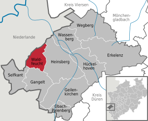
| Location of the community Waldfeucht in the district of Heinsberg | ||
  |
||

Waldfeucht is a municipality located on the border with the Netherlands in the North Rhine-Westphalian district of Heinsberg with around 8,800 inhabitants (as of 2016).
geography

Geographical location
Waldfeucht is located west of Heinsberg in the Selfkant natural area between the Wurm rivers in the east and the Maas in the west.
To the west, the state border between the Kingdom of the Netherlands and the Federal Republic of Germany forms the municipal boundary over a length of about 10 km. The highest point in the community at 72.7 m above sea level. NN is located south of the "Breuner Maar" between Bocket and Breberen, the lowest point in the kitsch break between the villages of Haaren and Karken on the municipal boundary at 31.7 m above sea level. NN .
Expansion of the municipal area
The extension from north to south is about 8.5 km, the extension from west to east about 6.0 km.
Community structure
In addition to the core town, the villages belong to the community of Waldfeucht
history
Traces of settlement and prehistoric burial sites prove the presence of people in the Waldfeucht municipal area since the 4th millennium BC. Today's localities of the community are either Franconian settlements of the 6th / 7th centuries. Century, or they emerged as clearing settlements in the 9./10. Century. They are all mentioned in documents from the 12th and 13th centuries.

As early as the 13th century, the village of Waldfeucht was the most important place in the surrounding area, which went beyond today's municipal boundaries. The location on the Roman road Heerlen - Xanten and on the road that led from Heinsberg through the Echter Bruch into the Maasland contributed significantly to this development and led to the fact that the ownership of Waldfeucht between the rival territories of Geldern , Burgundy , Brabant and Heinsberg for centuries was long controversial. The fortifications around Waldfeucht, today characterized by hedge paths and cottage gardens, which consisted of ramparts, ditches and two city gates that were destroyed in the Second World War, bear witness to these times.
The abundance of forests and the fertile arable soils formed the basis for the economic life of the community in the Middle Ages . Very early on, handicrafts and trading companies set up shop in Waldfeucht, from which the tanning and brewing trades were carried out up to our time. The metalworking and blacksmithing trade was in full bloom in Waldfeucht in the 16th century. Linen and velvet weaving was also carried out in Waldfeucht until the 19th century .
The demarcation established by the Congress of Vienna in 1815 cut up a cultural and economic area that had grown over centuries. Waldfeucht came to the Prussian Rhine Province and became a border town. Today's municipality of Waldfeucht was formed in connection with the Aachen Act on January 1, 1972 from the former office of Waldfeucht with the municipalities of Braunsrath, Haaren and Waldfeucht, as well as the districts of Haas and Haaserdriesch of the former municipality of Kirchhoven.
timeline
- from 4000 BC Chr .: Settlement of the municipality area proven by archaeological finds
- around 400 BC Chr .: Immigration of the Eburones
- 53 BC Chr .: Caesar's legions destroy the Eburones; Germanic tribes are settled.
- until AD 400: Roman administration, the Roman state road Heerlen - Xanten touches Waldfeucht.
- around 500: Francs colonize the Waldfeucht area.
- from 700: Irish-Scottish monks evangelize the Waldfeucht room.
- 800–900: Norman incursions; Lower moths are created as escape and defense systems.
- 1144: Brüggelchen, Frilinghoven (1147), Obspringen (1170), Braunsrath and Hontem (1202), Haaren (1217), Waldfeucht (1240), Bocket (1276), Löcken, Schöndorf and Selsten (1277) are first mentioned in a document.
- 1202: Waldfeucht is fortified with a castle and rampart. According to the chronicle of the Jesuit Jacobus Kritzraed († 1672), two brothers, Walterus and Joannes, knights of Vucht from the Maasland near s'Hertogenbosch, came to Waldfeucht in 1202, received the place as a fief and fortified it.
- 1227: Waldfeucht belongs to the Altena farm association in the Netherlands and has market rights.
- 1324: Waldfeucht is the seat of a jury.
- 1328: Ten bishops sign a letter of indulgence in Avignon for the "St. Jans-Klus", Haaren.
- 1370: Waldfeucht belongs to the Duchy of Brabant, the city fortifications are supplemented by two city gates and are given their shape that is still recognizable today.
- 1420: Johann II, Lord von Heinsberg , receives Waldfeucht as a hereditary fiefdom.
- 1433: The St. Sebastianus Schützenbruderschaft Waldfeucht issues a new statute.
- 1484: Waldfeucht falls to the Duchy of Jülich and is incorporated into the Jülisches Amt Millen.
- 1480/99, 1510/42/70: Conflagrations in forest damp
- 1500: The parish church of St. Lambertus, destroyed by fire, is rebuilt as a late Gothic brick basilica using Carolingian and Romanesque predecessor components.
- 1540–1550: There is a Reformed community in Waldfeucht.
- 1578: The Waldfeucht locksmiths' guild is founded.
- 1797: Braunsrath, Haaren and Waldfeucht form Mairien in the canton of Heinsberg in the department de la Roer, Aachen.
- 1801: Waldfeucht, which until then belonged to the diocese of Liège, is added to the diocese of Aachen.
- 1815: Waldfeucht and the Duchy of Jülich become part of the Kingdom of Prussia and become a border town.
- 1935: Formation of the Waldfeucht office with the mayor offices of Braunsrath, Haaren, Saeffelen and Waldfeucht
- 1945: war destruction; the city gates are blown up.
- 1969: Saeffelen leaves the office of Waldfeucht.
- 1972: On January 1st, the municipality of Waldfeucht is formed from the municipalities of the previous office of Waldfeucht.
- 1995: On March 26th, the border controls in the Schengen area no longer exist. The Waldfeucht customs office is canceled.
places
- Waldfeucht 1240: Watfuthe, 1277: Vochte, Voght, 1477: Vucht, 1513 Waltvucht; Wat = short form of "Watghero / Waltghero / Waltherus"; futhe = early spelling for Vochte / Vucht = "moisture"; Watfuthe / Waltvucht = "Futhe / Vucht des Watghero / Waltghero / Waltherus" (Waltherus, a Friedelohn of Boudewijn von Altena, received the place as a fiefdom around 1200); Waldfeucht had a jury since the 13th century and formed a mayor's office with Bocket, Harzelt, Langbroich and Schierwaldenrath. In 1935, Waldfeucht and Bocket became part of the newly formed Waldfeucht Office.
- Bocket 1276: Bucholte = "beech trees"; Waldfeucht parish until 1851, then an independent parish
- Braunsrath 1202: Brunsdrode = "clearing of the Brun (Bruno)"; Braunsrath had its own lay judge's court until 1560, after which it belonged to the Waldfeucht court and formed a mayor's office with Hontem, Löcken, Obspringen, Selsten and Schöndorf, which in 1935 became an official municipality of the newly formed Waldfeucht office.
- Brüggelchen 1144: Brugele = "swampy lowland"; Waldfeucht parish
- Driesch (Haaren) 1510: Driesch = "undeveloped land, pasture"
- Frilinghoven 1147: Vrilenhove, 1277: Vrilinchovin = "Courtyard of a Friling" (free), possibly also "Courtyard of the Frilo"; Waldfeucht parish
- Haaren 1217: de Hare = “enclosed, protected place (Hag)”. Other interpretations, for example "hill" (hare), are not convincing because of the location of the settlement. Waldfeucht parish until 1804, then an independent parish; formed a mayor's office with Soperich, Neuhaaren, Driesch, Brüggelchen and Frilinghoven, which in 1935 became an official municipality of the newly formed Waldfeucht office.
- Haas (Haaren) 1570: an gen Haas = "hare"
- Haaserdriesch (Haaren) "the pasture (Driesch) of the people from Haas"
- Hontem 1202: Huntheym = "home of Hunto"; Parish Braunsrath
- Löcken 1277: Lucken = "opening, gap clearing (luka)"; Parish Braunsrath
- Obspringen 1170: Obspringen = "on (to) the sources"; Waldfeucht parish, its own rectorate in 1911
- Schabroich (Haaren) 1550: Schaebroich = "Pasture justice (pasture area) in the break"
- Schöndorf 1277: Schondorp = "beautiful", possibly also "sloping, crooked" (because of the hillside location of the place); Parish Braunsrath
- Selsten 1277: Selsteiden = "place / place in the lowland"; Parish Braunsrath
- Soperich (Haaren) 1343: Soperich = "Possession / Empire of Supo", possibly from Superacum = "Court of Superus"
Population development
Total population on December 31st
|
|
|
|
|
politics
Municipal council
(As of: local elections on May 25, 2014 )
The engineer Heinz-Josef Schrammen was elected mayor in 2009.
Coat of arms, flag and banner

coat of arms

banner

Hoist flag

The official description of the coat of arms ( blazon ) in the certificate of the District President of Cologne dated March 14, 1977, with which the municipality of Waldfeucht was approved to use the coat of arms, reads: “Above a golden shield base, inside a black forest hook, in red a crowned, two-tailed silver one Lion". This coat of arms goes back to a seal (probably created in the second half of the 13th century) that can be found on several documents from 1345 to 1355. The seal shows the two-tailed crowned lion with the inscription: "Sigilum Judicis et Scabonarum Watvocht" (seal of the court and the lay judges at Waldfeucht). A three-pronged forest hook below the lion (also interpreted as a wolf tang or as a wall hook) is depicted in the Waldfeuchter coat of arms from 1484, when Waldfeucht came to the Duchy of Jülich and now had the (uncrowned, single-tailed) lion in the coat of arms until 1977.
Description of the banner: "Red-white-red in a ratio of 1: 4: 1 striped lengthways with the heraldic shield shifted upwards over the middle.
Description of the flag: "Red-white-red in a ratio of 1: 4: 1 striped lengthways with the heraldic shield shifted towards the pole.
Culture and sights
Buildings

- Several windmills have been preserved in the community, of which the mills in Waldfeucht und Haaren can be visited:
- The Waldfeuchter Windmühle, a tower windmill ( Erdholländer ), was built in 1897 and is considered the youngest windmill in the Rhineland. The first post mill - located as a town mill in the area of the town wall - was built around 1590 and overturned in the 19th century. The Waldfeuchter mill, which was built outside the wall, is operational and is used by millers from the Mühlenverein-Selfkant to grind grain.
- The Haarener Windmühle, a mountain Dutchman , was built in 1842 and is also operational. It is also used for grinding grain by the mill association.
- The tower of the former Löcken windmill is currently (2005) being restored and will serve as a residential building in the future.
- Churches:
- The parish church of St. Lambertus in Waldfeucht is a three-aisled late Gothic basilica from the 15th to 16th centuries. The relatively long choir with a noticeable axis deviation from the nave has a choir closure constructed from a decagon.
- The St.-Jans- (St.-Johannes-) Klus in Haaren, a former baptistery, which was probably built in the 8th / 9th centuries. It was built in the 16th century and in 1328 received a letter of indulgence issued by ten bishops as an “old place of pilgrimage”. The Klus served as the Parish Church for Hair from 1804 to 1824 and was founded by Irish and Scottish monks. In the immediate vicinity there is a Roman-Franconian cemetery on Dutch territory.

- Of the Motte Bolleberg , the mound of earth in the former swamp area, on which there was an escape and weir system, can still be clearly seen. It was probably built in the 9th century. However, the surrounding moat has been filled in.
- The "Schlösschen", a simple brick building with nine axes and two storeys, dates from the 17th to 18th centuries and is now used as the town hall and the seat of the local government.
Regular events
- Oktoberfest in hair
- Christmas market in Waldfeucht (on the 2nd Sunday of Advent)
Economy and Infrastructure
The Eisfabrik Rosen Eiskrem GmbH with an annual production of 230 million liters of ice cream (including for Aldi ) is the town's largest employer.
traffic
There are bus connections to the individual districts and neighboring towns. The nearest train stations (both 9 km away) are the Dutch train station Echt on the main railway line Eindhoven - Maastricht and the German train station Heinsberg (Rheinl) on the Wurmtalbahn, which was reactivated on December 15, 2013 . The road network of the municipality has a length of about 72 km, of which 50 km are local roads, 17 km district roads and 5 km country roads. The municipality's network of agricultural roads is around 170 km long, of which around 80 km are developed and at the same time dedicated as cycle paths and around 90 km (so-called “green paths”) are not developed.
Personalities
- Johannes von den Driesch (1562–1616), professor of canon and civil law at the University of Würzburg, was born in Waldfeucht.
Others
- In 1989, Waldfeucht was awarded a gold medal in the national competition “Our village should become more beautiful”.
- In 2009, Waldfeucht was awarded a gold medal in the state competition Our Village Has Future .
- In 2010, Waldfeucht was awarded a silver medal in the national competition Our Village Has Future .
- Lt. IT / NRW ranked Waldfeucht with an average taxable income (2010) per taxpayer of € 24,404 p. a. in last place of the 396 municipalities in North Rhine-Westphalia. The average in NRW was € 33,199.00.
Picture gallery
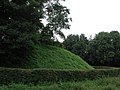
Motte Bolleberg, former escape and weir system

Marienkapelle Brüggelchen, entrance

Marien Altar of the Marienkapelle Brüggelchen

Marienkapelle Brüggelchen, side view

Bergholländer Waldfeucht-Haaren

Thank you boards at the Waldfeucht field chapel

Waldfeucht field chapel

Windmill Waldfeucht, a Dutchman
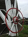
Windmill Waldfeucht, the wing tracking
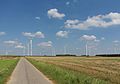
Modern windmills


literature
- Paul Clemen (Hrsgb.), Karl Franck-Oberaspach, Edmund Renard (editor): The art monuments of the Rhine province. 8th volume, III: The art monuments of the Heinsberg district . L. Schwann, Düsseldorf 1906, p. 112 ff.
Web links
- Website of the community of Waldfeucht
- Monuments in the municipality of Waldfeucht
- Churches and chapels in the municipality of Waldfeucht
- A WDR film about hair
- Website of the historical mills association in Selfkant eV
swell
- ↑ Population of the municipalities of North Rhine-Westphalia on December 31, 2019 - update of the population based on the census of May 9, 2011. State Office for Information and Technology North Rhine-Westphalia (IT.NRW), accessed on June 17, 2020 . ( Help on this )
- ^ Federal Statistical Office (ed.): Historical municipality directory for the Federal Republic of Germany. Name, border and key number changes in municipalities, counties and administrative districts from May 27, 1970 to December 31, 1982 . W. Kohlhammer, Stuttgart / Mainz 1983, ISBN 3-17-003263-1 , p. 310 .
- ↑ Martin Bünermann, Heinz Köstering: The communities and districts after the municipal territorial reform in North Rhine-Westphalia . Deutscher Gemeindeverlag, Cologne 1975, ISBN 3-555-30092-X , p. 73 .
- ↑ State Returning Officer NRW: Results of the 2014 local elections for Waldfeucht. Retrieved January 20, 2016 .
- ↑ Article in Handelsblatt from May 20, 2007 about rose ice cream

Erkelenz | Gangelt | Geilenkirchen | Heinsberg | Hückelhoven | Selfkant | Übach-Palenberg | Forest damp | Wassenberg | Wegberg
Bocket | Braunsrath | Brüggelchen | Frilinghoven | Hair | Hontem | Lock | Obspringen | Schondorf | Selsten | Forest damp