
City wall Aachen

The city wall of Aachen was a double wall ring that was supposed to protect the city of Aachen from attacks. It was built in two stages, the inner ring from 1172, the outer one from around 1300.
Only parts of both walls, their numerous towers and city gates have been preserved. Of the towers, only the former watchtower Lavenstein , the Lange Turm , the Marienturm , the Pfaffenturm and the small Adalbertsturm still exist . The two still preserved city gates , the Marschiertor and the Ponttor , were badly damaged in the Second World War , but could be restored.
Inner city wall

The construction of Aachen's inner city wall , which is also called the inner ring , first wall or Barbarossa wall , began in 1172. The trigger was Emperor Friedrich I Barbarossa , who in 1171 made the citizens of Aachen promise to protect Aachen, which he provided with coinage , market and city rights in 1166, with a city wall. The first wall is called the Barbarossa Wall after him. Aachen was given the condition to build a wall completely surrounding the city at that time within four years. During the construction of the inner city wall, the thermal springs of the Lower Aachen spring group were discovered in the area of today's Komphausbadstrasse .
The wall was built as a cast wall. A normal wall was erected on both sides. The gap was filled with stones in layers and grouted with mortar. The wall ring built in this way had a length of 2480 meters, the thickness varied between 1.5 and 2.5 meters. When the inner ring was completed is not known, but apparently some sections of the inner ring were only protected by walls and palisades when Aachen was sieged by Wilhelm of Holland in 1248 .
In today's street scene there are larger remains of the inner city wall in the area of the university quarter of the Rheinisch Westfälische Technische Hochschule am Templergraben. Other remains can be seen on the Seilgraben and on the Minoritenstraße. There is also a notice board pointing to the former city wall.

Excavations show that the wall was built on an earth wall. At the time of the Franks, stone defensive structures were not in use. Instead, earth walls were built up. Outside the wall there was a trench that is still recognizable today due to its special soil structure. It was 2,550 meters long, 5 meters deep and 25 meters wide. On the east side of the city, where the terrain was flat, this ditch was filled with water from Johannisbach and Pau ; on the west side, where there were steep slopes, it was dry. Along this ditch, a ring road was later laid parallel to the course of the wall, the current “Grabenring”, the sub-streets of which mostly end on “-graben” (Hirschgraben, Seilgraben, Dahmengraben, Holzgraben, Kapuzinergraben, Alexianergraben, Löhergraben, Karlsgraben and Templergraben).

The evaluation of old drawings from the 16th century suggests ten city gates and ten towers, although some historians deviate from this and assume only eight original gates. After the construction of the second city wall, some of the gates of the first city wall were given the suffix “Central Gate” to distinguish them from the newly built outer gates. They were in the middle of the walk from the city center to the outer gate. For example, the old Kölntor, which was located in Großkölnstraße at the height of Mefferdatisstraße, was renamed Kölnmittelor after the new Kölntor was built on today's Hansemannplatz . There was also the Jakobs , König , Marschier and Pontmittelor gates . The five other gates were called Besterdertor , Harduinstor , Neutor , Scherptor and Ursulinertor . The main gates were the Pontmittelor in the north, the Kölnmittelor in the east, the Marschiermittelor in the south and the Jakobsmittelor in the west. Most of the gates of the Barbarossa Wall were simple square gate towers . Only the Scherptor is said to have been a gate with two towers. A drawbridge led across the moat. The four main gates had barbican , so front gates on the outside of the moat , for better defense .

The first gates to be torn down were the Marching Middle Gate, also known as the Burtscheider Middle Gate, and the Jakobs Middle Gate, probably as early as the end of the 16th century. The Königs-Mitteltor and the Neutor followed in 1764 and the Besterdertor in 1783. The remaining gates disappeared in the course of the general demolition of the city fortifications in the first quarter of the 19th century.
On the east side of the inner city wall, the city gates were relatively close to each other. On the west side, on the other hand, there were long walls without a gate, which were secured by additional towers. This additional security was also necessary because the city moat could not be filled with water because of the terrain and was therefore easier to negotiate than the moat on the east side. Most of these towers have not been given a name. Some of these towers were just bulwarks ; H. semicircular or rectangular projections of the city wall without wall end on the city side. Others were semicircular or round full towers, there were no square towers in the inner city wall except for the city gates.
Unlike the second, outer wall that was built later, the first enclosed a grown and built-up area of the city. Existing structures, existing settlements and streets had to be taken into account so that a circular wall construction was not possible. So could z. For example, the course of the wall between Pontmittelor and Neutor was not straight, but had to make a bend around it to include the house of the Lords of Punt at the site of the later Teutonic Order Coming St. Aegidius , which was otherwise avoided as much as possible. This kink was secured by a round tower.
The inner city wall also had porches outside the wall. Three of them stood roughly at the places where the Marschiertor , the Ponttor and the Long Tower were later built, two were formed by the church towers of St. Jakob and St. Peter built as a defensive tower .
Outer city wall

Since the inner wall soon restricted the growth of the city of Aachen, the citizens began to build a second wall ring around the city at a greater distance. The exact construction time is uncertain, a start in 1257, as is often assumed in view of a donation from Richard of Cornwall on the occasion of his coronation in Aachen, is rather improbable. At this point in time the inner wall still had to be completed, and the dedication of the donation for the fortification of the city related more to this work and the outer works than to the outer city wall. It is therefore assumed that construction will start towards the end of the 13th century and the fortification will be completed towards the middle of the 14th century.

While the first, inner wall was built around an already existing built-up area, the second, outer wall could be laid out generously. So it was possible to build an almost circular structure. It was laid out in such a way that the Carolingian complex of the Palatinate and Palatine Chapel moved into the center. Most of the area enclosed by the outer wall was only used for agriculture until the 19th century, and there was only settlement on the main arterial roads.
The outer wall was built using a similar process to the inner one. It was about 5,300 m long, 8–10 m high and 2–3 m thick, and up to 4 m in particularly endangered areas. On the city side it had arched niches with loopholes , on the top of the wall battlements with widths of 1–4 m and spaces of 70–80 cm. A kennel was required between Junkerstor and Jakobstor because of the terrain , the Lütticher Schanze . Sections of the wall between the gates and towers were additionally protected by bay windows , from which one could shoot at the area directly on the city wall. The guard houses for the guards of the towers and gates were distributed along the inside of the wall ring . A trench with a width of about 24–28 m was also dug around the outer wall. Where it was filled with water, it had a depth of about 7–8 m, in the dry places a depth of about 10–12 m.

Napoleon I ordered the demolition of the city fortifications, but this was only partially carried out during the French occupation of Aachen . He had the area between Hansemannplatz, where the former Kölntor was located, and the Ponttor green. Court gardener Maximilian Friedrich Weyhe was commissioned with this task . This is how the streets Monheimsallee and Ludwigsallee and the Heinrichsallee towards Adalbertstor were created, after which the street ring, on which the course of the outer city wall can still be recognized today, is called "Alleenring". From the Ponttor, the ring today follows the streets Pontwall, Turmstraße, Junkersstraße, An der Schanz (where the Liège Schanze was) and Boxgraben to the Marschiertor. Between Marschiertor and Adalbertstor, the course of the avenue ring deviates from the former course of the wall, this roughly followed the course of Wallstrasse, Schützenstrasse, Gottfriedstrasse, Martin-Luther-Strasse.
During the expansion of the city in the 19th century and the construction of the railway lines, the remaining parts of the city fortifications were demolished, only two city gates and five towers escaped destruction. While a few isolated wall sections of the inner wall are still preserved, only the wall approaches of the outer wall are left on the preserved gates and towers.
City gates

The outer city wall had a total of eleven city gates , of which only the Ponttor and the Marching Gate have survived . Occasionally the water tower is considered the twelfth gate because of its large water passage. A measurement showed that all city gates except for the former Jakobstor were arranged on a circular path with the center on the Katschhof , an open space between the octagon of the cathedral and the town hall .

The four main gates were the Ponttor in the north, the Kölntor in the east, the Marschiertor in the south and the Jakobstor in the west. Other gates were the Bergtor and the Sandkaultor between the Ponttor and the Kölntor , the Adalbertstor and the Wirichsbongardstor between the Kölntor and the Marschiertor , the Rostor between the Marschiertor and the Jakobstor and the Junkerstor and the Königstor between the Jakobstor and the Ponttor .
Nine of these gates also served as the seat of the nine counties under the command of a captain, into which the bells of the Aachen Empire were divided, i.e. the area around Aachen that could be warned of dangers by the ringing of the city bells.
The completely preserved (or restored) Ponttor best shows the basic structure of the city gates of the outer wall ring. The main building was either a rectangular building like the Ponttor or, like the Marschiertor, consisted of two round towers connected by a central building. The front gates ( barbican ) that stood outside the dry or water-filled trench were constructed in a similar way, only smaller . Only the Junkerstor had no front gate. The main building and the entrance gate were connected by a stone bridge that spanned the moat. At the sides, these bridges were protected by crenellated walls.
Towers

The outer wall had 23 towers, of which only a few have survived. Since the outer city wall was about twice as long as the inner one with about the same number of gates, towers were also arranged between the individual gates on the east side. But also with the outer wall ring, the towers were concentrated on the west side for the reasons already mentioned for the inner city wall, especially in the northwest, where there were six towers between the Königstor and Ponttor. As with the inner city wall, there were also bulwark towers and full towers on the outer city wall. In addition to the semicircular and round full towers, there were also those with a square floor plan.
The widest of the remaining towers is the Marienturm , which is also called Marienburg. On its sides there are still clearly recognizable remains of the outer city wall. The name results from the laying of the foundation stone on the Assumption Day , August 14th, 1512. Today there is a memorial for the victims of both world wars.
The Long Tower, also known as the Powder Tower, was the highest and at the same time the tallest structure on the outer city wall. It is located in today's Turmstrasse, used to be a watchtower and, due to its exposed location, also served as a fire station.
In addition to these structures, three smaller round towers have been preserved: the Lavenstein on Boxgraben, the Pfaffenturm in Junkerstrasse and the Adalbertsturm on Kaiserplatz .
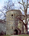
Lavenstein

Pfaff tower

Long tower

Adalbertsturm


See also
- Gates and towers of the Aachen city wall
- Bay window of the Aachen city wall
- Guard houses of the Aachen city wall
literature
- Richard Pick : Report on an official inspection of the city wall in Aachen around 1450 . In: Aachener Geschichtsverein (Hrsg.): Journal of the Aachener Geschichtsverein . tape 7 . Benrath & Vogelsang, Aachen 1885, p. 286–288 ( Text Archive - Internet Archive [accessed May 5, 2015]).
- Carl Rhoen : The fortifications of the free imperial city of Aachen . Anton Creutzer, Aachen 1894 urn : nbn: de: hbz: 061: 1-230540 ( stadtgeschichte.isl.rwth-aachen.de [PDF; accessed on May 6, 2016]).
- Richard Pick: From Aachen's past. Contributions to the history of the old imperial city . Anton Creutzer, Aachen 1895, Aachen's fortification in the Middle Ages, p. 113–171 ( ULB Düsseldorf [accessed on May 6, 2016]).
- Brigitt Sigel: City and Country Walls. vdf Hochschulverlag, 1995, ISBN 3-7281-2055-3 .
- Axel Hausmann : Atuatuka: Caesar's legion camp in Aachen. Books on Demand, 2001, ISBN 3-8311-2860-X .
- Bruno Lerho : The great Aachen city wall with gates and towers . Helios Verlag, 2006, ISBN 3-938208-37-6 .
- Zeitungsverlag Aachen (ed.): Step by step. Experience history (s) on foot. Meyer & Meyer Verlag, ISBN 3-89899-446-5 .
Web links
Individual evidence
- ↑ a b c d e Axel Hausmann: Atuatuka . Caesar's legion camp in Aachen. Books on Demand, 2001, ISBN 3-8311-2860-X , pp. 179 .
- ^ Richard Pick: When did Aachen get its first fortification? In: From Aachen's prehistory . 1st year, no. 2 . Aachen 1888, p. 97-104 ( Text Archive - Internet Archive [accessed August 14, 2015]).
- ↑ a b c d Research tasks on the Aachen city plan. In: Portal "City History and Urban Development Aachen". Working Group for Monument Preservation and Institute for Urban Development and Regional Planning at RWTH Aachen University , accessed on May 6, 2016 .
- ^ Carl Rhoen: The fortifications of the free imperial city of Aachen . Anton Creutzer, Aachen 1894, p. 12, 29 ( digital.ub.uni-duesseldorf.de [accessed on May 6, 2016]).