
Kesternich
|
Kesternich
community Simmerath
|
||
|---|---|---|
 |
||
| Height : | 553 m | |
| Area : | 7.84 km² | |
| Residents : | 1468 (December 31, 2011) | |
| Population density : | 187 inhabitants / km² | |
| Incorporation : | January 1, 1972 | |
| Postal code : | 52152 | |
| Area code : | 02473 | |
Location of Kesternich in North Rhine-Westphalia |
||

Kesternich is a district of Simmerath in the Aachen city region in North Rhine-Westphalia .
Geographical location
Kesternich is located in the northern Eifel along the L 166 and federal road 266 approx. 1 km east of the core town of Simmerath on the way to the Rurtalsperre, whose southern end ( Obersee ) is another 5 km east at Einruhr . This means that Kesternich is located on a touristically relevant through route in the Aachen / Monschau / Rurtalsperre triangle , but has a rural character.
history
Kesternich is located on the historic Roman road , which ran from the High Fens via Monschau- Konzen to Einruhr. In 1964 the foundations of a single Roman building (presumably a refreshment station) were discovered south of the village. The origin of the name can also be found here, it probably comes from "Castriniacum" which means "little soldiers' camp" or "little hostel".
Settlement is only documented in the 18th century. In 1717 there was the first Kesternich church , which belonged to the Simmerath parish. Until the end of the 18th century, this was politically subordinate to the Duchy of Jülich . After the entire Left Bank of the Rhine was occupied during the First Coalition War in 1794 , the area belonged to France from 1798 to 1814 . Simmerath and the surrounding area belonged to the canton of Montjoie in the arrondissement of Aachen in the Rur département . Due to the agreements reached at the Congress of Vienna in 1815 , the area was assigned to the Kingdom of Prussia , and from 1822 until the end of World War II it was part of the Rhine Province . In the winter months of 1944/45 there was heavy fighting during the advance of the Americans. A memorial (bronze plate) was placed on the fallen in 1993. Kesternich was almost completely destroyed in the fighting, but it was possible to maintain the traditional appearance during the reconstruction.
Until 1972, Kesternich belonged as an independent municipality to the also dissolved district of Monschau and this to the also dissolved administrative district of Aachen . Through the law of the state of North Rhine-Westphalia on the reorganization of the municipalities and districts of the reorganization area Aachen (the so-called Aachen law ) of December 14, 1971, the previously independent office of Kesternich, which had also co-administered Rurberg , Steckenborn and Strauch , became together with the previous office Simmerath and other localities merged on January 1, 1972 to form the new municipality Simmerath.
The district of Aachen and the legal successor urban region of Aachen have been planning a bypass for Kesternich since 2006 and justify this with the increased volume of traffic in the Eifel National Park . The urgency has now been postponed, and the route is also unclear.
Culture and sights

societies
Kesternich has an intensive club life.
Buildings
The building fabric is heterogeneous (half-timbered, plaster, greywacke, clinker construction); the historical center is located south of the B 266 (Brunnenstrasse / Ringstrasse), the new district on the western edge. The original building of the parish church St. Peter and Paul from 1717 is no longer traceable; Its current appearance goes back to a neo-Gothic new building from 1899, which was destroyed in the Second World War and then reconstructed. A neo-Gothic crucifix that an American soldier had taken with him and had it detoured back to its place of origin in 1983 remained undamaged. There are wooden sculptures of the 14 helpers above the right side altar .
Kesternich is located on the edge of the Monschau Heckenland and has the characteristic red beech windbreaks on some buildings .
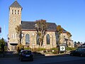
Parish church
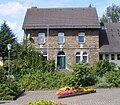
Rectory
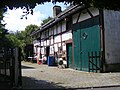
Courtyard stable
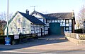
Half-timbered Winkelhofanlage, 18th century


Economy and Infrastructure
Public facilities
- Cemetery with chapel
- Sports fields
Municipal facility
- Simmerath volunteer fire brigade, Kesternich fire fighting group
education
- Kindergarten in the Aachen city region in Kesternich
Public transport
In public transport, Kesternich is connected to the following bus lines from the AVV area :
| line | course |
|---|---|
| 63 | Simmerath - Einruhr - Vogelsang (- Schleiden ) |
| 68 | (Lammersdorf -) Simmerath Bushof - Strauch - Steckenborn - Woffelsbach - Rurberg (- Einruhr) |
| 81 | ( Vossenack - Zweifallshammer -) Schmidt - Steckenborn - Strauch - Kesternich - Simmerath Hospital - Simmerath Bus Station |
Web links
- Website of the municipality of Simmerath
- Village tour Kesternich (PDF file; 314 kB)
Individual evidence
- ↑ Population figures in the community of Simmerath (main residence) at www.simmerath.de
- ↑ Location description on the Simmerath homepage , accessed on December 20, 2012
- ^ Federal Statistical Office (ed.): Historical municipality directory for the Federal Republic of Germany. Name, border and key number changes in municipalities, counties and administrative districts from May 27, 1970 to December 31, 1982 . W. Kohlhammer, Stuttgart / Mainz 1983, ISBN 3-17-003263-1 , p. 309 .

Dedenborn | Eicherscheid | Einruhr | Erkensruhr | Hammer | Deer scrap | Huppenbroich | Kesternich | Lammersdorf | Paustenbach | Rollesbroich | Rurberg | Simmerath | Steckenborn | Shrub | Witzerath | Woffelsbach