
Dalbenden Castle
| Dalbenden Castle | |
|---|---|
 Dalbenden Castle, aerial photo (2015) |
|
| Creation time : | 12th Century |
| Castle type : | Niederungsburg |
| Conservation status: | receive |
| Place: | Kall - Urft |
| Geographical location | 50 ° 30 '51.7 " N , 6 ° 34' 37.3" E |
The castle Dalbenden is a 12th-century moated castle resulting castle. The listed castle is located north of Urft , a district of the municipality of Kall in the North Rhine-Westphalian district of Euskirchen . Nearby is the Dalbenden outcrop of the Eifel aqueduct .
The castle was expanded in the 16th century to include the courtyard and other outbuildings. Another expansion took place in the 18th century, with the castle being expanded to include today's castle park.
The castle complex, which served as the headquarters of Field Marshal Gerd von Rundstedt during the Battle of the Bulge in 1944, was bombed by the American Air Force on December 8, 1944 and suffered severe damage.
After it was rebuilt, it was again badly affected by a fire in 1964.
Known residents
- Fritz von Wille 1905–1907
- Gerd von Rundstedt 1944
Dalbenden Castle, wall gate to the street
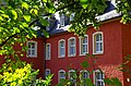
Dalbenden Castle, residential wing front

Dalbenden Castle, access to the courtyard
Inner courtyard with stairs

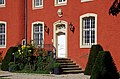
Dalbenden Castle, balcony and terrace front

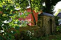
Dalbenden Castle, outer courtyard access

Dalbenden Castle, tower
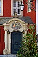
Entrance portal next to the tower


Web links
- Alexandra Zingler's entry on Dalbenden Castle in the " EBIDAT " scientific database of the European Castle Institute
- Website "Burg Dalbenden"
- Dalbenden Castle at eifelreise.de
- Entry on Schloss Dalbenden in the private database "Alle Burgen".
Individual evidence
- ↑ Fritz von Wille (1860-1941) on rheinische-geschichte.lvr.de