Olhão
| Olhão | ||||||
|---|---|---|---|---|---|---|
|
||||||
| Basic data | ||||||
| Region : | Algarve | |||||
| Sub-region : | Algarve | |||||
| District : | Faro | |||||
| Concelho : | Olhão | |||||
| Coordinates : | 37 ° 2 ′ N , 7 ° 50 ′ W | |||||
| Residents: | 14,914 (as of June 30, 2011) | |||||
| Surface: | 12.25 km² (as of January 1, 2010) | |||||
| Population density : | 1217 inhabitants per km² | |||||
| Olhão district | ||||||
|
||||||
| Residents: | 45,396 (as of June 30, 2011) | |||||
| Surface: | 130.87 km² (as of January 1, 2010) | |||||
| Population density : | 347 inhabitants per km² | |||||
| Number of municipalities : | 4th | |||||
| administration | ||||||
| Administration address: | Câmara Municipal de Olhão 8700-349 Olhão |
|||||
| President of the Câmara Municipal: | Francisco José Fernandes Leal ( PS ) | |||||
| Website: | www.cm-olhao.pt | |||||
Olhão [ oˈʎɐ̃ũ ] is a city in Portugal with 14,914 inhabitants (as of June 30, 2011). Olhão is located on the so-called sandy Algarve , the Sotavento . This is the name given to the stretch of land that stretches between Faro airport and the Spanish border in eastern Portugal.
history
Today's district area belonged to the Roman province of Lusitania . The Roman bridge in Quelfes is one of the most important traces from this time. After it belonged to the Arab al-Andalus since the early 8th century , the area became part of the Kingdom of Portugal with the conclusion of the Portuguese Reconquista around 1250 , but without being repopulated afterwards.
Today's place was re-established in the 17th century by fishermen who settled here and lived in simple straw huts. Solid stone houses based on the Moorish model were not built until the end of the 18th century.
A milestone in the development of Olhão was the victory against the Napoleonic invading forces in 1808 . Since it was a pioneer in the expulsion of the French occupiers from Portugal, the city received the lyrical honorary title of Olhão da Restauração (German: Olhão of the restoration) and was elevated to Vila (small town). King João VI (1767–1826) was living with his court in Brazil at this time. The good news of the victory was brought to him by a handful of "Olhanese" people. They had set out on the arduous journey across the Atlantic in a heroic journey in a small boat, only equipped with a rough nautical chart. Due to this initiative, the king showed himself to be connected to the place, which benefited the development.
Since the middle of the 20th century, the fishing industry has expanded. Olhão was promoted to city ( Cidade ) in 1985 .
Culture and sights
Within the district of Olhão is the Ria Formosa Nature Park , which is known for its unique bird life and, due to strict building regulations, influences the tourist development of the region.
The numerous architectural monuments include a number of historical public buildings, various apartment blocks from the social housing of the Estado Novo regime, the fortress from the 17th century, and two Baroque parish churches. The historic town center as a whole is also a listed building, and a tide mill can be seen a bit outside.
The Ecoteca-Museu João Lúcio is a museum on the ecology and nature of the region, which also develops and supports numerous regional environmental initiatives. In the municipal museum Museu Municipal , in addition to temporary exhibitions, there are also three permanent exhibitions on the Roman history of the district, the history of the salt pans of the place, and the seafaring and fishing history of Olhão.
Sports
The Sporting Clube Olhanense, founded in 1912, is located in the village . His professional soccer team rose to the Portuguese first division in 2009 . He plays his home games at the Estádio José Arcanjo . Basketball, cycling and futsal are also practiced at SC Olhanense.
administration
circle
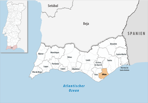
Olhão is the administrative seat of a district of the same name. The neighboring areas are (starting clockwise in the north): Tavira , Faro , São Brás de Alportel and the Atlantic Ocean.
With the territorial reform in September 2013 , the municipalities ( freguesias ) Moncarapacho and Fuseta were merged to form the new municipality União das Freguesias de Moncarapacho e Fuseta . Since then, the district has consisted of the following four municipalities:
| local community | Population (2011) |
Area km² |
Density of population / km² |
LAU code |
|---|---|---|---|---|
| Moncarapacho e Fuseta | 9,635 | 70.63 | 136 | 081006 |
| Olhão | 14,914 | 12.25 | 1,218 | 081003 |
| Pechão | 3,601 | 19.79 | 182 | 081004 |
| Quelfes | 17,246 | 28.20 | 612 | 081005 |
| Olhão district | 45,396 | 130.87 | 347 | 0810 |
Population development
| Population in Olhão County (1849–2011) | ||||||||
|---|---|---|---|---|---|---|---|---|
| 1849 | 1900 | 1930 | 1960 | 1981 | 1991 | 2001 | 2011 | |
| 11,934 | 24,276 | 27,664 | 30,871 | 34,573 | 36,812 | 40,808 | 45,396 | |
Municipal holiday
- June 16
Town twinning
-
 Morocco : Agadir (since 1993)
 -
 France : Lesparre-Médoc (since 1994)
 -
 France : Montalivet-les-Bains (since 1994)
traffic
The place is connected to Lagos , Faro and Vila Real de Santo António by the Linha do Algarve railway line .
The town is connected to Faro via the national road N125, which has been developed as an expressway, and to its junction with the A22 motorway (exit no. 14), 12 km away .
Olhão is part of the Rede Expressos national bus network.
Photos (selection)
Azulejo picture of the resistance of 1808
Well-known sons and daughters of the city
- Estêvão de Vasconcelos (1868–1917), doctor and politician
- João Lúcio Pousão Pereira (1880–1918), poet, nephew of the painter Henrique Pousão
- Alberto Iria (1909–1992), historian
- Maria Barroso (1925–2015), actress and wife of Mário Soares
- Mafalda Sofia (born 1943), singer
- Cidália Moreira (* 1944), actress and fado singer
- Manuel Cajuda (* 1951), football coach
- Nélson Vitorino (* 1975), racing cyclist
- Pete tha Zouk (* 1978), DJ and music producer
- Vasco Herculano Salgado Cunha Mango Fernandes (* 1986), football player
- Gonçalo Ramos (* 2001), football player
See also
Individual evidence
- ↑ www.ine.pt - indicator resident population by place of residence and sex; Decennial in the database of the Instituto Nacional de Estatística
- ↑ a b Overview of code assignments from Freguesias on epp.eurostat.ec.europa.eu
- ↑ www.ine.pt - indicator resident population by place of residence and sex; Decennial in the database of the Instituto Nacional de Estatística
- ^ João Fonseca: Dicionário do Nome das Terras. 2nd edition, Casa das Letras, Cruz Quebrada 2007, p. 183 ( ISBN 978-9724617305 )
- ↑ Olhão - História. Olhão Municipality website, accessed September 24, 2017.
- ^ Bairro de Casas para Pescadores de Olhão. Entry IPA.00025855 in the Portuguese register of monuments Sistema de Informação para o Património Arquitetónico (SIPA), accessed on September 24, 2017.
- ↑ Casa João Lúcio / Ecoteca de Olhão. Website of the municipality of Olhão, accessed September 24, 2017.
- ^ Museu Municipal. Website of the municipality of Olhão, accessed September 24, 2017.
- ↑ Reorganização administrativa do Território the freguesias. Publication of the administrative reorganization in the Diário da República law gazette of January 28, 2013, pp. 552- (83).
- ↑ www.anmp.pt , accessed January 5, 2013
Web links
- Map of the Freguesia Olhão at the Instituto Geográfico do Exército
- Olhão City Council website


