
Loulé
| Loulé | ||||||
|---|---|---|---|---|---|---|
|
||||||
| Basic data | ||||||
| Region : | Algarve | |||||
| Sub-region : | Algarve | |||||
| District : | Faro | |||||
| Concelho : | Loulé | |||||
| Coordinates : | 37 ° 8 ′ N , 8 ° 1 ′ W | |||||
| Residents: | 70,163 (as of June 30, 2011) | |||||
| Surface: | 763.68 km² (as of January 1, 2010) | |||||
| Population density : | 92 inhabitants per km² | |||||
| Postal code : | 8100 | |||||
| County of Loulé | ||||||
|
||||||
| Residents: | 70,163 (as of June 30, 2011) | |||||
| Surface: | 763.68 km² (as of January 1, 2010) | |||||
| Population density : | 92 inhabitants per km² | |||||
| Number of municipalities : | 9 | |||||
| administration | ||||||
| Administration address: | Câmara Municipal de Loulé Praça da República 8100-270 Loulé |
|||||
| Website: | www.cm-loule.pt | |||||
.png)


Loulé [ loˈlɛ ] is a district town in the south of Portugal in the Algarve , about 16 kilometers north of Faro .
history

Finds prove a settlement since the Paleolithic . From the Iron Age onwards, other peoples increasingly came here. Carthaginians and Phoenicians settled here. From the 2nd century BC BC the Romans subjugated the area, and as a result an economic boom began. From 711 the Moors conquered the area. Loulé became an Arab city that has shaped the historic center to this day.
King D.Afonso III. conquered the city from the Arabs in 1249 and gave it city rights in 1266. In the course of the beginning of the Portuguese voyages of discovery and the Portuguese Empire that emerged in the 16th century, Loulé, like a number of places in the Algarve, experienced an economic boom. The earthquake in Lisbon in 1755 caused severe destruction in Loulé, which severely set back the development of the place.
Since the 20th century, the city has seen considerable changes in terms of its economy and urban development. This was not least due to tourism , from which the district was able to benefit, for example with its touristically developed towns such as Quarteira and Vilamoura, which attract a large number of international visitors.

The city's Brazilian-inspired carnival parade , which attracts numerous visitors from all over the country every year , is also known nationwide.
Culture and sights
Buildings, sights
- Roman villa of Vilamoura southwest of Loulé.
- Castle Castelo de Loulé in the city center
- Three-aisled main church Igreja Matriz da São Clemente
- Chapel of Nossa Senhora da Piedade
- Neo-Moorish market hall
- Bell tower next to the Church of São Clemente, probably based on a minaret from the 10th or 11th century

Exhibitions and museums
- Archaeological Museum
Regular events
- Farmers market (every Saturday morning at the market hall)
- Carnival in Avenida José da Costa Mealha. It is considered one of the most colorful in all of Portugal
- Loulé Jazz Festival (annually in July since 1995, under the direction of Mário Laginha )
- Festival MED (since 2004, every year at the end of June / beginning of July, Mediterranean music and culture festival, world music festival)
Sports
In Estádio Algarve more games were the 2004 European Football Championship instead. Since 1994 Loulé has hosted the Algarve Cup , which every spring hosts some of the best national women's football teams.

The most important sports club here is the Louletano Desportos Clube, founded in 1923 . After a few seasons in the second Portuguese division, his professional soccer team is now back in the third highest division (2013).
The Centro Ciclismo de Loulé-Louletano cycling team , which is dedicated to professional cycling races, is based in Loulé . On the other hand, the Clube BTT Terra de Loulé pursues cycling in the form of mountain bike competitions .
In the Pavilhão Desportivo Municipal de Loulé , a World Cup in the sport of trampoline gymnastics is held every year .
gallery

The main church of Loulé

Loulé

Minaret tower
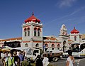
Market hall

Place at the market hall
.jpg)


administration
circle
Loulé is the largest district in the Algarve and borders on the districts (starting clockwise from the north): Almodôvar , Alcoutim , Tavira , São Brás de Alportel , Faro , Albufeira , Silves and the Atlantic Ocean.
With the territorial reform in September 2013, the municipalities ( freguesias ) Querença , Tôr and Benafim were merged to form the new municipality União das Freguesias de Querença, Tôr e Benafim . Since then, the district has consisted of the following nine municipalities:
The Loulé district is divided into nine municipalities ( Freguesias ):

| local community | Population (2011) |
Area km² |
Density of population / km² |
LAU code |
|---|---|---|---|---|
| Almancil | 10,677 | 62.30 | 171 | 080801 |
| Old | 1.997 | 94.33 | 21st | 080802 |
| Ameixial | 439 | 123.85 | 4th | 080803 |
| Boliqueime | 4,973 | 46.21 | 108 | 080804 |
| Quarteira | 21,798 | 38.16 | 571 | 080805 |
| Querença, Tôr e Benafim | 2,713 | 102.18 | 27 | 080812 |
| Salir | 2,775 | 187.75 | 15th | 080807 |
| São Clemente | 17,358 | 46.20 | 376 | 080808 |
| São Sebastião | 7,433 | 62.70 | 119 | 080809 |
| County of Loulé | 70.163 | 763.68 | 92 | 0808 |
Population development
| Population in Loulé County (1801–2011) | |||||||||
|---|---|---|---|---|---|---|---|---|---|
| 1801 | 1849 | 1900 | 1930 | 1960 | 1981 | 1991 | 2001 | 2011 | |
| 13,503 | 16,137 | 44,403 | 44,026 | 45.126 | 44.051 | 46,585 | 59,160 | 70,622 | |
Municipal holiday
- Ascension of Christ
Town twinning
-
 Cape Verde : Boa Vista (Cape Verde)
-
 Brazil : Aquiraz , State of Ceará (cooperation agreement)
 -
 Spain : Cartaya
-
 Guinea-Bissau : Bissoarã , Oio region
-
 France : Le Puy-Notre-Dame
-
France : Créteil
-
 People's Republic of China : Haikou (under negotiation)
 -
 Mozambique : Manica (in preparation)
 -
 Argentina : Belén de Escobar (in preparation)
 -
 Angola : Benguela (in preparation)

economy
Tourism is an important industry. In addition to a large salt mine in Loulé, there are many handicraft businesses that manufacture unglazed pottery, leather goods and large copper kettles for distilling schnapps, among other things.
traffic
Loulé is connected to Lagos , Faro and Vila Real de Santo António by the Linha do Algarve railway line .
The city has two separate junctions on the A22 motorway .
The place is integrated into the national bus network of Rede Expressos .


sons and daughters of the town
- José Mendes Cabeçadas Júnior (1883–1965), Vice Admiral and Republican politician, 1926 Prime Minister
- Francisco Xavier Cândido Guerreiro (1871–1953), lawyer, local politician, poet and playwright
- Duarte Pacheco (1900–1943), engineer, university professor and politician, minister in the Estado Novo regime
- Maria Campina (1914–1984), pianist
- Manuel Correia Abreu (1915–1983), educator and local politician
- Manuel da Luz Afonso (1917–2000), coach of the national soccer team at their third World Cup place in 1966
- Laura Ayres (1922–1992), doctor and virologist
- Rogério Fernandes Ferreira (1929–2010), economist, university professor and government advisor
- Casimiro de Brito (* 1938), writer and translator, especially of haikus
- Aníbal Cavaco Silva (* 1939), President of the Republic, previously Prime Minister
- António José Cavaco Carrilho (* 1942), Bishop of Funchal
- Júlio Guerreiro (1944–2011), journalist and city organizer, innovator of the carnival that has since become popular across the region
- Lídia Jorge (* 1946), writer
- José Sousa Ramos (1948–2007), mathematician and university professor
- António Laginha (* 1955), dancer, choreographer, journalist and university professor
- Felícia Cabrita (* 1963), journalist and author
- José Carlos Fernandes (* 1964), comic book author
- Miguel Farrajota (* 1967), rally driver
- Ana de Sousa Baptista (* 1971), writer
- Nuno Guerreiro (* 1972), musician, best known as the singer of the successful pop group Ala dos Namorados
- Idalécio Silvestre Lopes Soares Rosa (* 1973), football player
- Jamila Madeira (* 1975), socialist politician
- Victória Guerra (born 1989), actress
Web links
Individual evidence
- ↑ a b www.ine.pt - indicator resident population by place of residence and sex; Decennial in the database of the Instituto Nacional de Estatística
- ↑ a b Overview of code assignments from Freguesias on epp.eurostat.ec.europa.eu
- ↑ www.verportugal.net , accessed on August 25, 2013
- ^ Information from the district administration on the annual World Cup trampoline gymnastics , accessed on November 2, 2014
- ^ Publication of the administrative reorganization in the Diário da República gazette of January 28, 2013, accessed on March 16, 2014
- ↑ www.anmp.pt , accessed on August 25, 2013

Albufeira | Alcoutim | Aljezur | Castro Marim | Faro | Lagoa | Lagos | Loulé | Monchique | Olhão | Portimão | São Brás de Alportel | Silves | Tavira | Vila do Bispo | Vila Real de Santo Antonio