Aljezur
| Aljezur | ||||||
|---|---|---|---|---|---|---|
|
||||||
| Basic data | ||||||
| Region : | Algarve | |||||
| Sub-region : | Algarve | |||||
| District : | Faro | |||||
| Concelho : | Aljezur | |||||
| Coordinates : | 37 ° 19 ′ N , 8 ° 48 ′ W | |||||
| Residents: | 3365 (as of June 30, 2011) | |||||
| Surface: | 166.76 km² (as of January 1, 2010) | |||||
| Population density : | 20 inhabitants per km² | |||||
| Height: | 38 m | |||||
| Postal code : | 8670 | |||||
| politics | ||||||
| Address of the municipal administration: | Junta de Freguesia de Aljezur Rua Capitão Salgueiro Maia 8670-005 Aljezur |
|||||
| Website: | www.jf-aljezur.pt | |||||
| Aljezur district | ||||||
|
||||||
| Residents: | 5884 (as of June 30, 2011) | |||||
| Surface: | 323.5 km² (as of January 1, 2010) | |||||
| Population density : | 18 inhabitants per km² | |||||
| Number of municipalities : | 4th | |||||
| administration | ||||||
| Administration address: | Câmara Municipal de Aljezur Rua Capitão Salgueiro Maia 8670-005 Aljezur |
|||||
| President of the Câmara Municipal: | José Manuel Velhinho Amarelinho ( PS ) | |||||
| Website: | www.cm-aljezur.pt | |||||
Aljezur is a small town ( Vila ) in the south of Portugal . It has 3365 inhabitants (as of June 30, 2011) and belongs to the Faro district . The area west of the village is part of the Parque Natural do Sudoeste Alentejano e Costa Vicentina National Park .
history
The old town is dominated by a Moorish castle ruin from the 10th century. Traces of settlement were found here that go back to the Iron Age . The Almoravids and Almohads had the castle, which lies in a loop of the Ribeira de Aljezur, significantly expanded between the 11th and the first half of the 13th century. Since then, the outer walls have been 1.5 m thick and the corner towers 9 m high. Small forts and watchtowers extended the defense system into the surrounding area. A rainwater cistern, which is 7.3 m long, 5.7 m wide and has an average internal height of 3.8 m, also dates from this period. An inner and an outer layer of mortar 4 cm thick made the structure watertight.
Aljezur was snatched from the Almohads by the Santiagoorden under the direction of Dom Paio Peres Correia around 1249 . The order set up storage facilities and barracks at the castle and controlled the area around the fortress in a wide area. Alfonso X of Castile and Alfonso III. of Portugal agreed in the Treaty of Badajoz in 1267 on the rights to numerous castles in the Algarve , with Aljezur going to Dom Dinis of Portugal, the son of Alfonsus III.
In 1280 Dinis granted Aljezur town charter, taking on half of the maintenance of the castle, the other half being taken over by the Knights of Aljezur. A town hall was built on today's square on October 5th, which has housed the city museum, the Museo Municipal, since 2000. At the end of the 15th century the castle had lost its military function and was given up.
On the slopes below the castle a town had emerged that reached down to the river. An important port was built there, as the only natural port on the rugged Atlantic coast was located south to Lagos; the river was also the only one to be navigable until it silted up in the 16th and 17th centuries. The trade contacts reached to Flanders in the north and to Castile, but especially to Tavira and Lisbon . Cloth played an important role, but also dried fruits, honey, olive oil, spices and medicinal products. The fees and charges were collected in a separate customs house. The income from the fishing fees went to the city hospital. It was fished in the rivers as well as on the Atlantic.
In the river valley there were extensive fields of grain, the yields of which were processed into flour at the mills on the river. The grain was exported to the African fortresses of Portugal. The Portuguese fleet was also equipped with biscoito , a type of ship's biscuit . Horticulture and viticulture supplied export products and supplied the regional market. There were also pigs, cattle, sheep and goats, as well as melons, coriander , beans and other agricultural products. Beekeeping and hunting were encouraged in the steeper areas.
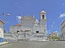
The earthquake in Lisbon in 1755 , which affected practically all of Portugal, was a sharp cut . Across the river and about a kilometer from the old town, the new town around the Igreja Nova was built on the initiative of the Bishop of Faro , Francisco Gomes de Avelar (1739-1816), who wanted to offer the population after 1755 a safer place to stay. Today, the majority of the population lives here, and they increasingly live from tourism. Nevertheless, the market remains an important distribution center for the sparsely populated region, along with administrative and cultural tasks.
administration
Aljezur district
Aljezur is the administrative seat of a district of the same name. The neighboring areas are (starting clockwise in the north): Odemira , Monchique , Lagos and Vila do Bispo .
The following four municipalities ( freguesias ) make up the Aljezur district:
| local community | Population (2011) |
Area km² |
Density of population / km² |
LAU code |
|---|---|---|---|---|
| Aljezur | 3,365 | 166.76 | 20th | 080301 |
| Bordeira | 432 | 79.87 | 5 | 080302 |
| Odeceixe | 961 | 41.91 | 23 | 080303 |
| Rogil | 1,126 | 34.96 | 32 | 080304 |
| Aljezur district | 5,884 | 323.50 | 18th | 0803 |
Population development
| Year: | 1801 | 1849 | 1900 | 1930 | 1960 | 1981 | 1991 | 2001 | 2004 |
| Residents: | 1790 | 2780 | 5053 | 6977 | 8139 | 5059 | 5006 | 5288 | 5322 |
Municipal holiday
- 29th August
Town twinning
Web links
- Map of the Freguesia Aljezur at the Instituto Geográfico do Exército
- Aljezur - official website of the city administration
Individual evidence
- ↑ www.ine.pt - indicator resident population by place of residence and sex; Decennial in the database of the Instituto Nacional de Estatística
- ↑ a b Overview of code assignments from Freguesias on epp.eurostat.ec.europa.eu
- ↑ www.ine.pt - indicator resident population by place of residence and sex; Decennial in the database of the Instituto Nacional de Estatística
- ↑ www.anmp.pt , accessed on February 3, 2013


