Arronches
| Arronches | ||||||
|---|---|---|---|---|---|---|
|
||||||
| Basic data | ||||||
| Region : | Alentejo | |||||
| Sub-region : | Alto Alentejo | |||||
| District : | Portalegre | |||||
| Concelho : | Arronches | |||||
| Coordinates : | 39 ° 7 ′ N , 7 ° 17 ′ W | |||||
| Residents: | 3165 (as of June 30, 2011) | |||||
| Surface: | 314.65 km² (as of January 1, 2010) | |||||
| Population density : | 10 inhabitants per km² | |||||
| Postal code : | 7340 | |||||
| Arronches county | ||||||
|
||||||
| Residents: | 3165 (as of June 30, 2011) | |||||
| Surface: | 314.65 km² (as of January 1, 2010) | |||||
| Population density : | 10 inhabitants per km² | |||||
| Number of municipalities : | 3 | |||||
| administration | ||||||
| Administration address: | Câmara Municipal de Arronches Praça da República Apartado 8 7340-012 Arronches |
|||||
| President of the Câmara Municipal: | Fermelinda de Jesus Pombo Carvalho ( PPD / PSD ) | |||||
| Website: | www.cm-arronches.pt | |||||
Arronches is a small town ( Vila ) and a district ( Concelho ) in eastern Portugal with 3165 inhabitants (as of June 30, 2011).
history
A large number of finds prove a prehistoric settlement. The place was probably founded as a Roman settlement in the province of Lusitania at the time of the Emperor Caligula , but there is no clear evidence. After the Arab conquest in 711, Arronches belonged to al-Andalus . The place name goes back to the first inhabitants of the place, who came from the place Aroche in today's province of Huelva in Spain.
In the course of the Reconquista , King D. Afonso Henriques conquered the place in 1166 for the now independent Kingdom of Portugal . However, the place remained contested. After a reconquest by the Moors, King D.Sancho II took possession of Arronches again in 1235 . The place received its first city rights in 1255. After repeated attacks by the Arabs, Paio Peres Correia managed to finally recapture the place in 1242. During the revolution of 1383 , Castile took possession of Arronches until Nuno Álvares Pereira recaptured the place in 1384.
In the course of his administrative reforms, King D. Manuel I renewed the town charter in 1512 . In the course of the Restoration War , the place fell under João de Áustria to Habsburg Spain in 1661 , but it was recaptured by Portugal in the same year, in one of the decisive battles of the Restoration War. King Pedro I renewed Arronches' town charter in 1678. In 1712 the place fought off one last attempt at conquering Spain.
Culture and sights
A number of megalithic complexes can be seen here, mostly called Antas in Portuguese . Even rock paintings can be seen that Sitios de pintura rupestre de Arronches (including Lapa dos Gaivões ). Other architectural monuments include stone fountains, mansions , remains of various fortifications, historical private and public buildings as well as various sacred buildings , such as the former monastery church Igreja de Nossa Senhora da Luz do Convento dos Religiosos Agostinhos Calçados (also Igreja de Nossa Senhora da Luz ) from the 16th century Century.
The historic town center is also a listed building as a whole.
The Museu de (a) Brincar (German: about: Museum of Play) deals with the history of play and toys, and offers educational offers. Traditional handicrafts are shown in various small establishments in the village and some are sold.
Sports
The football club Arronches e Benfica , founded in 1939 and a subsidiary of Benfica Lisbon , plays in the association's top regional league in the Portalegre district and plays its home games in the Estádio Municipal de Arronches . The Atlético Clube de Arronches , which also has futsal departments, also play there. Other sports clubs are the Centro Republicano Arronchense, founded in 1902, and the futsal club Terrimponente Associação Cultural Desportiva e Recreativa, which has existed since 2011 . In the Pavilhão Municipal de Arronches , an urban sports hall complex, the home games of the futsal teams take place.
administration
circle
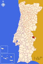
Arronches is the administrative seat of a district of the same name that borders Spain in the northeast . The neighboring areas are (starting clockwise in the north): Portalegre , Campo Maior , Elvas and Monforte .
The following municipalities ( Freguesias ) are in the Arronches district:
| local community | Population (2011) |
Area km² |
Density of population / km² |
LAU code |
|---|---|---|---|---|
| Assunção | 1,970 | 204.51 | 10 | 120201 |
| Esperança | 739 | 57.15 | 13 | 120202 |
| Mosteiros | 456 | 52.99 | 9 | 120203 |
| Arronches county | 3.165 | 314.65 | 10 | 1202 |
Population development
| Population in Arronches County (1801–2011) | |||||||||
|---|---|---|---|---|---|---|---|---|---|
| 1801 | 1849 | 1900 | 1930 | 1960 | 1981 | 1991 | 2001 | 2004 | 2011 |
| 2470 | 2970 | 4990 | 6205 | 6818 | 4307 | 3677 | 3389 | 3278 | 3119 |
Municipal holiday
- June 24th
traffic
Since the Linha do Leste railway line was closed in 2012, Arronches has no connection to the country's railway network.
The national road N246 connects Arronches with Elvas and its connection to the A6 motorway in the south, and with the district capital Portalegre in the north. The N371 leads to Campo Maior , while the N243 connects the place with Monforte and its connection to the IP2 (here also European route E 802).
Local public transport is provided by regional bus routes operated by Rodoviária do Alentejo , part of the Barraqueiro group .
sons and daughters of the town
- Francisco Aranha (1603–1677), Jesuit theologian and author
- Álvaro de Castelo-Branco (1619–1668), theologian and author
- Francisco Xavier Aranha († 1771), Bishop of the Olinda Diocese , Brazil
- Edmundo Curvelo (1913–1954), philosopher, logician and translator
- Artur Semedo (1924–2001), director, actor and screenwriter
- Francisco Palmeiro Rodrigues (* 1932), football player
Web links
Individual evidence
- ↑ a b c www.ine.pt - indicator resident population by place of residence and sex; Decennial in the database of the Instituto Nacional de Estatística
- ↑ a b Overview of code assignments from Freguesias on epp.eurostat.ec.europa.eu
- ^ Entry of the battle in the Infopédia , the online encyclopedia of the Porto Editora , accessed on July 10, 2013
- ^ João Fonseca: Dicionário do Nome das Terras . 2nd Edition. Casa das Letras, Cruz Quebrada 2007, ISBN 978-972-46-1730-5 , p. 39.
- ↑ history page of the district website; Retrieved July 10, 2013.
- ↑ verportugal.net accessed on July 10, 2013
- ↑ monumentos.pt accessed on July 10, 2013
- ↑ ditto
- ^ Museum website , accessed July 10, 2013
- ↑ List of houses on the district website; Retrieved July 10, 2013
- ↑ fussballzz.de accessed on July 10, 2013
- ↑ traffic page of the district website; Retrieved July 10, 2013


