Campo Maior
| Campo Maior | ||||||
|---|---|---|---|---|---|---|
|
||||||
| Basic data | ||||||
| Region : | Alentejo | |||||
| Sub-region : | Alto Alentejo | |||||
| District : | Portalegre | |||||
| Concelho : | Campo Maior | |||||
| Coordinates : | 39 ° 1 ′ N , 7 ° 4 ′ W | |||||
| Residents: | 8456 (as of June 30, 2011) | |||||
| Surface: | 247.2 km² (as of January 1, 2010) | |||||
| Population density : | 34 inhabitants per km² | |||||
| Campo Maior district | ||||||
|
||||||
| Residents: | 8456 (as of June 30, 2011) | |||||
| Surface: | 247.2 km² (as of January 1, 2010) | |||||
| Population density : | 34 inhabitants per km² | |||||
| Number of municipalities : | 3 | |||||
| administration | ||||||
| Administration address: | Câmara Municipal de Campo Maior 7370-999 Campo Maior |
|||||
| President of the Câmara Municipal: | Ricardo Miguel Furtado Pinheiro ( PS ) | |||||
| Website: | www.cm-campo-maior.pt | |||||
Campo Maior is a small town ( Vila ) and a district ( Concelho ) in Portugal with 8,456 inhabitants (as of June 30, 2011).
history
Finds prove a prehistoric settlement of the area. Also in the 2nd century BC Chr. Sunken Romans settled here, as well as from 711 sunken Moors . The Pérez family from Badajoz recaptured the place from the Arabs in 1219 . In 1255 King Alfonso X raised Campo Maior to vila (small town). With the Treaty of Alcañices , the place came to the Kingdom of Portugal in 1297 . King D Dinis had the fortress rebuilt and expanded in 1310 .
Due to the continuing Spanish influence, the place was on the side of Castile in the revolution of 1383 and was finally recaptured by the Portuguese crown after the siege in 1388 . The population has increased since the end of the 14th century when people fleeing from Spain settled here and fled the Inquisition there. In this context, the Jewish community also grew significantly. King Manuel I gave Campo Maior Portuguese city rights in 1512 .
In the course of the Restoration War from 1640 , the place was again heavily fortified. It remained an important fortress town and was the target of a Spanish invasion in 1712 , which was repulsed. In 1732 the place suffered severe destruction and as a result a significant decrease in population when a strong storm with lightning strikes caused the powder chambers of the fortress to explode. King D. João V had the place rebuilt. As a result of the strong repopulation in 1766, the place was divided into two parishes, Nossa Senhora da Expectação and São João Baptista.
In 1801 the site resisted a Spanish invasion, and in 1808 the site rose against the French occupiers in the Napoleonic Wars on the Iberian Peninsula , who were driven out of Badajoz with the help of troops. The Spanish troops stayed in town for three years. In 1811 there was another French invasion. After strong local resistance against the invaders, the arriving British-Portuguese troops under General Beresford were able to liberate the place again.
After a cholera epidemic greatly reduced the population in 1865 , the planned dissolution of the independent Campo Maior district in 1867 was only averted by strong resistance from the population. In 1926 his third parish was added to the district with Nossa Senhora dos Degolados, and in 1941 the formerly important neighboring district of Ouguela was finally dissolved and incorporated into the parish of São João Baptista.
Culture and sights
The remains of the Roman dam of Muro are nearby. Other architectural monuments include other Roman excavations (mines, a villa rustica and parts of a Roman road ), including various sacred buildings , fountains, historical public buildings and mills, country estates, fortifications, etc. The historic centers of Ouguela and Campo Maior are also included as a whole Monument protection.
In the cultural complex Centro Cultural de Campo Maior concerts, performances, exhibitions, conferences and other such place. The Lagar Museu, opened in 2005 in the listed manor house of the Count of Olivã ( Palácio Visconde d'Olivã ) from the 17th century, deals extensively with the cultivation and processing of olives . The city library ( Biblioteca Municipal ) is also housed there. The museum for sacred art , which is centrally located in the Capela da Nossa Senhora do Carmo , and the city museum Museu Aberto are other cultural sites in the area. The only coffee museum on the Iberian Peninsula is located on the Delta Cafés premises . In this context it also deals with the Portuguese colonial history .
Campo Maior is known nationwide for its irregular folk festival, the Festas do Povo ( which takes place at the end of August ), for which the whole city is brightly decorated. After 2004, the 2011 folk festival, also known as Festas das Flores (German: Flower Festival), took place, lasted one week, and was opened by President Cavaco Silva . An application for the entry of the popular festival of Campo Maior on the Representative List of the Intangible Cultural Heritage of Humanity at UNESCO has been submitted for 2020.
Sports
Founded in 1926, SC Campomaiorense played for a long time in the First Portuguese Football League until it retired from professional sport in 2002. He last played in the fourth division ( IIIª Divisão ) and played his home games in the Estádio Capitão Cesar Correia, which has a capacity of 7,500 . After the 2011/2002 season, the club stopped playing.
economy
Agriculture has traditionally been the most important factor in the local economy. Olive oil is of particular importance, including wheat. The ham of the Iberian pig produced here is also known .
The international coffee manufacturer Delta Cafés is the market leader in Portugal and one of the largest employers in the district.
administration
The circle
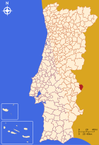
Campo Maior is the administrative seat of a district of the same name that borders Spain to the north and east . The neighboring districts are (starting clockwise in the north): Elvas and Arronches .
The following municipalities ( Freguesias ) are in the Campo Maior district:
| local community | Population (2011) |
Area km² |
Density of population / km² |
LAU code |
|---|---|---|---|---|
| Nossa Senhora da Expectação | 3,974 | 105.06 | 38 | 120401 |
| Nossa Senhora da Graça dos Degolados | 587 | 35.75 | 16 | 120402 |
| São João Baptista | 3,895 | 106.39 | 37 | 120403 |
| Campo Maior district | 8,456 | 247.20 | 34 | 1204 |
Population development
| Population in the district of Campo Maior (1801–2011) | |||||||||
|---|---|---|---|---|---|---|---|---|---|
| 1801 | 1849 | 1900 | 1930 | 1960 | 1981 | 1991 | 2001 | 2004 | 2011 |
| 4975 | 4416 | 6050 | 8234 | 9887 | 8549 | 8535 | 8387 | 8359 | 8456 |
Town twinning
-
 Campo Maior (Brazil) , State of Piauí , Brazil (since 2010)
 -
 Ermera , East Timor (since 2013)
Personalities
- Beatrix da Silva Meneses (1424–1492), noble founder of the order, saint
- Beato Amadeu da Silva (1438–1482), noble Franciscan, saint
- Francisco Xavier Craveiro Lopes (1814-1883), military
- Fernando Mouzinho de Albuquerque (1874–1942), military, district head of Coimbra and head of the Benguela Railway
- José Joaquim Ribeiro (1918–2002), Bishop in East Timor
- Vítor Caldeira (* 1960), President of the European Court of Auditors
Web links
Individual evidence
- ↑ a b www.ine.pt - indicator resident population by place of residence and sex; Decennial in the database of the Instituto Nacional de Estatística
- ↑ a b Overview of code assignments from Freguesias on epp.eurostat.ec.europa.eu
- ↑ History page on the website of the district administration (port.), Accessed on May 26, 2013
- ↑ www.monumentos.pt , accessed on May 26, 2013
- ↑ ditto
- ↑ ditto
- ^ Lydia Hohenberger, Jürgen Strohmaier: Portugal. 2nd edition, DuMont Reiseverlag, Ostfildern 2009
- ↑ TV recording on YouTube , accessed on May 26, 2013
- ↑ Website on the intangible world heritage in Portugal at UNESCO (English, French and Spanish), accessed on January 14, 2020
- ↑ List of Campo Maiors partnerships with the Association of Portuguese District Governments , accessed on January 5, 2019


