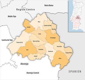
Alto Alentejo
| Alto Alentejo | |
|---|---|

|
|
| Basic data | |
| Country |
|
| region | Alentejo |
| Capital | Portalegre |
| population | 118,506 (2013) |
| Population density | 19.5 inhabitants per km² |
| surface | 6,084.29 km² |
| Circles | 15th |
| Communities | 69 |
| ISO-3166-2 code | PT-186 |
Alto Alentejo is a Portuguese sub-region and is identical to the Portalegre district . In the north it borders on the sub-region of the Pinhal Interior Sul and the Beira Interior Sul , in the east on Spain , in the south the Alentejo Central and in the west the Lezíria do Tejo and the Médio Tejo . The area of the sub-region is: 6230 km². The population in 2001 was 127,025. There are 15 districts in the sub-region:
| circle | Number of municipalities |
Population (2011) |
Area km² |
Density of population / km² |
LAU code |
District |
|---|---|---|---|---|---|---|
| Alter do Chão | 4th | 3,562 | 362.06 | 10 | 1201 | Portalegre |
| Arronches | 3 | 3.165 | 314.65 | 10 | 1202 | Portalegre |
| Advice | 6th | 4,571 | 605.95 | 8th | 1203 | Portalegre |
| Campo Maior | 3 | 8,456 | 247.20 | 34 | 1204 | Portalegre |
| Castelo de Vide | 4th | 3,407 | 264.91 | 13 | 1205 | Portalegre |
| Crato | 4th | 3,708 | 398.07 | 9 | 1206 | Portalegre |
| Elvas | 7th | 23,078 | 631.28 | 37 | 1207 | Portalegre |
| Fronteira | 3 | 3,410 | 248.59 | 14th | 1208 | Portalegre |
| Gavião | 4th | 4.132 | 294.59 | 14th | 1209 | Portalegre |
| Marvão | 4th | 3,512 | 154.90 | 23 | 1210 | Portalegre |
| Monforte | 4th | 3,329 | 420.25 | 8th | 1211 | Portalegre |
| Nisa | 7th | 7,450 | 575.67 | 13 | 1212 | Portalegre |
| Ponte de Sor | 5 | 16,722 | 839.71 | 20th | 1213 | Portalegre |
| Portalegre | 7th | 24,930 | 447.14 | 56 | 1214 | Portalegre |
| Sousel | 4th | 5,074 | 279.32 | 18th | 1215 | Portalegre |
| Alto Alentejo | 69 | 118.506 | 6,084.29 | 19th | 186 | - |