Fronteira (Portugal)
| Fronteira | ||||||
|---|---|---|---|---|---|---|
|
||||||
| Basic data | ||||||
| Region : | Alentejo | |||||
| Sub-region : | Alto Alentejo | |||||
| District : | Portalegre | |||||
| Concelho : | Fronteira | |||||
| Coordinates : | 39 ° 3 ′ N , 7 ° 39 ′ W | |||||
| Residents: | 2069 (as of June 30, 2011) | |||||
| Surface: | 141.39 km² (as of January 1, 2010) | |||||
| Population density : | 15 inhabitants per km² | |||||
| Fronteira district | ||||||
|
||||||
| Residents: | 3410 (as of June 30, 2011) | |||||
| Surface: | 248.59 km² (as of January 1, 2010) | |||||
| Population density : | 14 inhabitants per km² | |||||
| Number of municipalities : | 3 | |||||
| administration | ||||||
| Administration address: | Câmara Municipal de Fronteira Praça do Município 7460-110 Fronteira |
|||||
| President of the Câmara Municipal: | Pedro Namorado Lancha ( PSD ) | |||||
| Website: | www.cm-fronteira.pt | |||||
Fronteira ( Portuguese for: border) is a small town ( Vila ) and a district ( concelho ) in the Portuguese Alentejo with 2069 inhabitants (as of June 30, 2011).
history
The local presence of humans for about 10,000 years is documented. Presumably the Romans maintained a fortified place here. After the conquest of the Iberian Peninsula by the Moors in the early 8th century AD, the place was probably abandoned.
During the Reconquista , Fernão Rodrigues Monteiro († 1237), a Grand Master of the Order of Avis , re-established the place for King Dinis and settled it.
In the Portuguese Revolution of 1383 , Fronteira was the scene of fighting. The battle of Batalha dos Atoleiros on April 6, 1384 , in which the Portuguese forces under Nuno Álvares Pereira defeated the numerically superior army of the Kingdom of Castile, should be mentioned in particular . King John I then granted Fronteira a number of privileges, but only King Manuel I gave the place full city rights ( Foral ) in 1512 .
After the Fronteira district had consisted of two municipalities for several centuries, namely Nossa Senhora da Atalaia de Fronteira and São Saturnino , it experienced numerous changes in the course of the various administrative reforms after the Liberal Revolution of 1822 . In 1867, the Fronteira district itself was dissolved and Alter do Chão was incorporated, but in 1868 it was independent again. After several parishes were newly incorporated or hived off to the districts of Monforte and Sousel, today's Fronteira district with its three parishes has existed since the last change in 1932 , when the parish of Santo Amaro was spun off to the district of Sousel.
Culture and sights
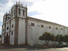
The historic town center is a listed building as a whole. A number of historical public buildings, remains of fortifications, stone fountains, a water mill, the train station and various sacred buildings are among the architectural monuments of Fronteira, including the Mannerist - Baroque main church Igreja Paroquial de Fronteira (also Igreja de Nossa Senhora da Atalaia ) from the 16th century. The Monumento comemorativo da Batalha de Atoleiros (also Terreiro da Batalha dos Atoleiros ) commemorates the battle of April 6, 1384 and is also a listed building. In 2012 the community set up a museum “Centro de Interpretação da Batalha de Atoleiros” to commemorate the battle.
The Ribeira Grande astronomical observation station is another attraction. The nature reserve Espaço eco-turístico da Ribeira Grande with its hiking trails and nature trails around the Ribeira Grande watercourse is also worth seeing.
administration
circle
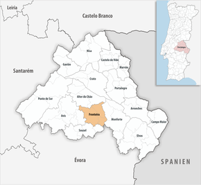
Fronteira is the administrative seat of a district of the same name. The neighboring areas are (starting clockwise in the north): Alter do Chão , Monforte , Estremoz , Sousel and Avis .
The following municipalities ( Freguesias ) are in the Fronteira district:
| local community | Population (2011) |
Area km² |
Density of population / km² |
LAU code |
|---|---|---|---|---|
| Cabeço de Vide | 1,063 | 65.81 | 16 | 120801 |
| Fronteira | 2,069 | 141.39 | 15th | 120802 |
| São Saturnino | 278 | 41.39 | 7th | 120803 |
| Fronteira district | 3,410 | 248.59 | 14th | 1208 |
Population development
| Population in Fronteira District (1801–2011) | ||||||||||||
|---|---|---|---|---|---|---|---|---|---|---|---|---|
| 1801 | 1849 | 1900 | 1930 | 1960 | 1981 | 1991 | 2001 | 2004 | 2006 | 2007 | 2008 | 2011 |
| 2182 | 2366 | 3385 | 4774 | 7063 | 4452 | 4122 | 3732 | 3422 | 3286 | 3240 | 3200 | 3410 |
Municipal holiday
- April 6th
economy
Agriculture and the processing of agricultural products are the main economic factors in the district. Mention should be made of olive oil and cork , but above all the cultivation of cereals and vegetables. Livestock breeding also has some significance here.
Tourism has gained in importance in the district and is mostly operated as rural tourism , for example in the listed Herdade dos Aroeirais estate and other mostly baroque mansions . However, the thermal baths in the municipality of Cabeço de Vide are the most important for tourism .
Handicrafts , especially embroidery , are another line of business in the area.
traffic
The place was a stop on the Ramal de Portalegre railway line . Since its closure in 1990, Fronteira has no longer had a connection to the Portuguese rail network.
The national road N245 connects Fronteira with Estremoz, about 30 km south, and its connection to the A6 motorway .
Fronteira is integrated into the national bus network of Rede Expressos .
sons and daughters of the town
- Manuel Cardoso (1566–1650), composer, choir director, organist and singer
- Cândido de Oliveira (1896–1958), journalist, football player and coach
Web links
- Map of the Freguesia Fronteira (Portugal) at the Instituto Geográfico do Exército
- Official website
Individual evidence
- ↑ a b www.ine.pt - indicator resident population by place of residence and sex; Decennial in the database of the Instituto Nacional de Estatística
- ↑ a b Overview of code assignments from Freguesias on epp.eurostat.ec.europa.eu
- ↑ www.ine.pt - indicator resident population by place of residence and sex; Decennial in the database of the Instituto Nacional de Estatística
- ^ João Fonseca: Dicionário do Nome das Terras . 2nd edition, Casa das Letras, Cruz Quebrada 2007, p. 120 ( ISBN 978-9724617305 )
- ↑ www.verportugal.net , accessed on July 13, 2013
- ↑ History on the circle's website ( Memento of the original from May 30, 2013 in the Internet Archive ) Info: The archive link was inserted automatically and has not yet been checked. Please check the original and archive link according to the instructions and then remove this notice. , accessed July 13, 2013
- ↑ Entry of the place in the Infopédia , accessed on July 13, 2013
- ↑ ditto ( memento of the original dated May 30, 2013 in the Internet Archive ) Info: The archive link was automatically inserted and not yet checked. Please check the original and archive link according to the instructions and then remove this notice.
- ↑ ditto
- ↑ www.monumentos.pt , accessed on July 13, 2013
- ↑ ditto
- ^ Website of the district ( Memento of the original from May 31, 2013 in the Internet Archive ) Info: The archive link was inserted automatically and has not yet been checked. Please check the original and archive link according to the instructions and then remove this notice. (under Observatório ), accessed July 13, 2013
- ↑ Entry in Infopédia , the online encyclopedia of the Porto Editora , accessed on July 13, 2013
- ↑ www.monumentos.pt , accessed on July 13, 2013
- ↑ The thermal baths on the municipality's website ( memento of the original dated November 7, 2013 in the Internet Archive ) Info: The archive link was inserted automatically and has not yet been checked. Please check the original and archive link according to the instructions and then remove this notice. , accessed July 13, 2013


