Crato
| Crato | ||||||
|---|---|---|---|---|---|---|
|
||||||
| Basic data | ||||||
| Region : | Alentejo | |||||
| Sub-region : | Alto Alentejo | |||||
| District : | Portalegre | |||||
| Concelho : | Crato | |||||
| Coordinates : | 39 ° 17 ′ N , 7 ° 39 ′ W | |||||
| Residents: | 3708 (as of June 30, 2011) | |||||
| Surface: | 398.07 km² (as of January 1, 2010) | |||||
| Population density : | 9.3 inhabitants per km² | |||||
| Crato County | ||||||
|
||||||
| Residents: | 3708 (as of June 30, 2011) | |||||
| Surface: | 398.07 km² (as of January 1, 2010) | |||||
| Population density : | 9.3 inhabitants per km² | |||||
| Number of municipalities : | 4th | |||||
| administration | ||||||
| Administration address: | Câmara Municipal de Crato Praça do Município 7430-999 Crato |
|||||
| President of the Câmara Municipal: | João Teresa Ribeiro ( CDU ) | |||||
| Website: | www.cm-crato.pt | |||||
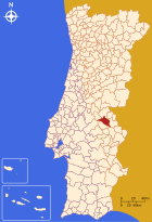
Crato is a small town ( Vila ) and a district ( Concelho ) in Portugal with 3708 inhabitants (as of June 30, 2011).
history
With around 70 Antas, a large number of megalithic sites in the district prove a prehistoric settlement. The Anta do Crato (also called Anta do Tapadão or Anta da Aldeia da Mata) is located about 400 m north of the train station on a hill between the Ribeira da Seda and the Ribeiro do Chocanal. Of the original seven supporting stones, the approximately 2.0 m high, relatively wide front stone and four wall stones have been preserved. The capstone is in situ . The corridor and the hill have not been preserved. It is a wide-chambered Anta. The place was in the 3rd century BC. BC as Castraleuca , Castraleucos or Cattaleucos a city of Carthage . From the 2nd century conquered Romans , the Iberian Peninsula , and the site became part of the province of Lusitania . Two bridges and excavations of villas are the most important Roman finds in the district. The two four-arch bridges are located 1.5 km and 2.5 km south of Crato and can be seen from National Road 245. The Roman road in between has been preserved. Not much is known about the time since the invasion of barbarian tribes from the 5th century, and even under Arab rule from 711 the place was not specifically mentioned.
During the Reconquista , Portugal's first king Afonso Henriques conquered the place from the Moors in 1160 . In the course of the consolidation of the Kingdom of Portugal , which has been independent since 1140, and its settlement policy, Crato was then handed over to the Hospitaller Order. It received its first town charter in 1270 . From 1340 it was chosen as the Portuguese seat of the Hospitallers, who from 1356 also took up residence in the Convento Flor da Rosa monastery .
King Manuel I renewed the city rights of Cratos in 1512 as part of his administrative reforms. He married in 1519 here also Eleanor of Castile , his third wife. Also his son, King João III. , married here, but other sources cite Lisbon as the place of his marriage to Catherine of Castile in 1525 .
During the war of restoration , Spanish- Hapsburg troops under João de Áustria destroyed the place in 1662 . The fortress and city walls were not rebuilt afterwards. In 1790 Crato came back into the possession of the Portuguese king. It has remained an independent group to this day.
administration
circle
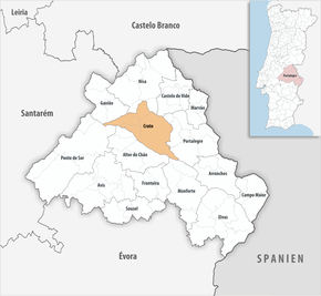
Crato is the administrative seat of a district of the same name. The neighboring districts are (starting clockwise in the north): Gavião , Nisa , Castelo de Vide , Portalegre , Monforte , Alter do Chão and Ponte de Sor .
With the territorial reform in September 2013, the municipalities ( freguesias ) Crato e Mártires , Flor da Rosa and Vale do Peso were merged to form the new municipality União das Freguesias de Crato e Mártires, Flor da Rosa e Vale do Peso . Since then, the district has consisted of the following four municipalities:
The following municipalities ( Freguesias ) are in the Crato district:
| local community | Population (2011) |
Area km² |
Density of population / km² |
LAU code |
|---|---|---|---|---|
| Aldeia da Mata | 374 | 37.28 | 10 | 120601 |
| Crato e Martires, Flor da Rosa e Vale do Peso | 2,198 | 254.56 | 9 | 120607 |
| Gáfete | 856 | 46.15 | 19th | 120604 |
| Monte da Pedra | 280 | 60.08 | 5 | 120605 |
| Crato County | 3,708 | 398.07 | 9 | 1206 |
Population development
| Population in Crato County (1801–2011) | ||||||||||
|---|---|---|---|---|---|---|---|---|---|---|
| 1801 | 1849 | 1900 | 1930 | 1960 | 1981 | 1991 | 2001 | 2004 | 2006 | 2011 |
| 2968 | 3069 | 6074 | 8253 | 8642 | 5642 | 5064 | 4348 | 3995 | 3835 | 3708 |
Municipal holiday
- Easter Monday
Town twinning
traffic
Since the end of passenger traffic on the Linha do Leste railway line in 2012, Crato has no connection to the country's railway network.
The place is integrated into the national bus network of Rede Expressos .
The national road N245 connects Crato with the 14 km northern Alpalhão and its connection to the IP2 (here also European road E 802). The district capital Portalegre can be reached via the IC13 25 km to the west.

sons and daughters of the town
- Roderigo Lopes (1525–1594), personal physician to the Queen of England
- Anabela Cardoso , diplomat and parapsychologist
literature
- Thomas G. Schattner (Ed.): Archaeological guide through Portugal (= cultural history of the ancient world . Vol. 74). Philipp von Zabern, Mainz 1998, ISBN 3-8053-2313-1 p. 126
Individual evidence
- ↑ a b c www.ine.pt - indicator resident population by place of residence and sex; Decennial in the database of the Instituto Nacional de Estatística
- ↑ a b Overview of code assignments from Freguesias on epp.eurostat.ec.europa.eu
- ^ João Fonseca: Dicionário do Nome das Terras . 2nd edition, Casa das Letras, Cruz Quebrada 2007, p. 95 ( ISBN 978-9724617305 )
- ↑ www.monumentos.pt (under Cronologia ), accessed on July 15, 2013
- ↑ ditto
- ↑ ditto
- ↑ History page of the parish website ( memento of the original from March 4, 2016 in the Internet Archive ) Info: The archive link has been inserted automatically and has not yet been checked. Please check the original and archive link according to the instructions and then remove this notice. , accessed July 15, 2013
- ↑ www.verportugal.net , accessed July 15, 2013
- ^ Publication of the administrative reorganization in the Diário da República gazette of January 28, 2013, accessed on March 16, 2014
- ↑ www.anmp.pt , accessed on July 15, 2013


