
Crato (Ceará)
| Município do Crato Crato |
|||
|---|---|---|---|
 |
|||
|
|||
| Coordinates | 7 ° 14 ′ S , 39 ° 25 ′ W | ||
 Location of the municipality in the state of Ceará Location of the municipality in the state of Ceará
|
|||
| Symbols | |||
|
|||
| founding | October 17, 1853 (Munizip) | ||
| Basic data | |||
| Country | Brazil | ||
| State | Ceará | ||
| ISO 3166-2 | BR-CE | ||
| Região intermediária | Juazeiro do Norte (since 2017) | ||
| Região imediata | Juazeiro do Norte (since 2017) | ||
| Metropolitan area | Cariri metropolitan area | ||
| structure | 10 districts | ||
| height | 426 m | ||
| climate | tropical, Aw / As | ||
| surface | 1,176.5 km² | ||
| Residents | 121,428 (2010) | ||
| density | 103.2 Ew. / km² | ||
| estimate | 131,372 (July 1, 2018) | ||
| Parish code | IBGE : 2304202 | ||
| Post Code | 63.100-000 to 63.139-999 | ||
| Time zone | UTC −3 | ||
| politics | |||
| City Prefect | José Ailton de Sousa Brasil (2017–2020) | ||
| Political party | PP | ||
| Culture | |||
| Patron saint | Nossa Senhora da Penha | ||
| economy | |||
| GDP | 1,509,564 thousand. R $ 11,642 R $ per capita (2016) |
||
| HDI | 0.713 (2010) | ||
.svg) Crato in the Cariri metropolitan area
|
|||


Crato, officially Portuguese Município do Crato , is a Brazilian city in the state of Ceará . According to the 2010 census, the population was 121,428, the population was estimated at 131,372 as of July 1, 2018, who live in a community area of around 1176.5 km² and are called Cratenser (Portuguese cratenses ). The distance to the capital Fortaleza is 508 km. It is known for its location in the Araripe Geopark and is in the Cariri metropolitan area .
geography
Surrounding places are in the north Farias Brito , in the east Caririaçu , Juazeiro do Norte and Barbalha , in the west Nova Olinda and Santana do Cariri and in the south in Pernambuco Exu and Moreilândia . An agglomeration is developing with Juazeiro do Norte.
The city has several nicknames: “Berço da República do Brasil”, “Berço do Pe”. Cícero ”,“ Coração do Ceará ”,“ Terra de Alencar ”,“ Princesa do Cariri ”,“ Cratinho de Açúcar ”.
The landscape and biome are mainly characterized by Cerrado , Cerradão and Caatinga .
climate
The city has a tropical climate Aw according to the Köppen and Geiger climate classification . The average temperature is 25.1 ° C. The average rainfall is 1086 mm per year.
history
The place emerged from the Miranda Capuchin mission after a chapel was built there in honor of Nossa Senhora da Penha and a parish was founded. The mission looked after Indians from the tribes of Kariri, Quixeréu, Cariú, Cariuané, Calabaça and Icozinho. The area belonged to the Ceará captaincy , with the Pernambuco captaincy having a strong influence. Crato shares a border with today's Pernambuco in the south. In the early 1760s, permission had been given to found villages in the hinterland. The place was first called Missão do Miranda , then Missão dos Cariris Novos , then Aldeia do Brejo Grande and received on June 21, 1764 the status of a Vila and was called Vila Real do Crato . It was only the seventh village that had been founded in what is now Ceará. In 1799 the area became part of the autonomous Ceará during the colonial period. A landed gentry had formed in the region through the cultivation of sugar. Even before the province of Ceará was established in 1822, liberation movements took place in the Cariri region, so in 1817 the Republic of Crato (República do Crato) was proclaimed and the independence of all of Brazil from the Portuguese crown was declared, eight days later the monarchist landowner Leandro ended Bezerra Monteiro the dream of freedom, those responsible were imprisoned. Crato was also heavily involved in the Equator Confederation (Confederação do Equador), a secessionist revolt of 1824.
In 1828 the city council of Crato (Câmara de Vereadores) sent a delegation to the government in which it was about the establishment of a separate province of Cariri Novo , which was ignored. The idea was renewed by the Senator José Martiniano Pereira de Alencar of the Partido Liberal, who presented the same proposal to the Imperial Senate as a draft law on August 14, 1839, whereby the capital was to be Vila do Crato, which also had no consequences.
On October 17, 1853, Crato was given city status by Provincial Law No. 628.
In 1855 the first newspaper in the interior of Ceará was founded in Crato, the weekly O Araripe. In the last quarter of the 19th century, Crato was no longer involved in political disputes.
Urban politics
Since the local elections in Brazil in 2016, the executive has been the city prefect José Ailton de Sousa Brasil des Partido Progressista (PP) for the 2017 to 2020 term of office . The legislature rests with a city council ( Câmara Municipal ) made up of 19 elected persons ( vereadores ).
Community structure
Crato has 10 districts: Crato (headquarters), Baixio das Palmeiras, Belmonte, Campo Alegre, Dom Quintino, Monte Alverne, Bela Vista, Ponta da Serra, Santa Fé and Santa Rosa.
Population development
Source: IBGE (2018 figures are only estimates).
In 2010, 25.62% of the population were children and adolescents up to the age of 15. 83.11% lived in the urban zone in 2010, 16.89% in rural areas, in 1991 the figure was 20.24%. The urban area of the main town is given as around 4.9 km².

Ethnic composition
Ethnic groups according to the statistical classification of the IBGE (status 2010 with 121,328 inhabitants): Of these, 100,916 inhabitants lived in urban areas in 2010 and 20,512 in rural areas.
| group | Share (2010) | annotation |
|---|---|---|
| Pardos | 72,808 | Mixed races, mulattos , mestizos |
| Brancos | 37,813 | Whites, descendants of Europeans |
| Pretus | 9,328 | black |
| Amarelos | 1,326 | Asians |
| Indigenous people | 143 | indigenous population |
| without specification | - |
Standard of living and income
The human development index for cities, abbreviated HDI (Portuguese: IDH-M ), was at the very low value of 0.444 in 1991, at the low value of 0.577 in 2000, and 0.713 in 2010. The monthly average income in 2017 was a factor of 1.9 of the minimum income of R $ 880, in 2019 around 372 euros per month. The gross national product per capita was R $ 11,642 in 2016.
economy
The local economy is based on the agriculture of beans , corn , cassava , rice , monoculture cotton , sugar cane , cashew nuts , vegetables, bananas, avocados and various fruits. Extensive animal husbandry includes cattle, sheep, goats, pigs and poultry. Plant extraction relates to the recovery of various woods, to various species such as Palm BaBassu , the Oiticica ( licania rigida ), which for the recovery of oiticica used, and the carnauba palm , from the carnauba wax is prepared.
The craft of embroidery and the production of hanging mats are another source of income. The city also sells industrial products such as aluminum, shoes, ceramics and brandy to the other urban centers of Ceará.
The quarry supplies building materials such as decorative stone, there are suitable sites for sand and clay for tiles and bricks, and limestone for extracting lime and gypsum for the production of Portland cement.
Crato has an industrial park. The Expocrato agricultural exhibition (Exposição Centro Nordestina de Animais e Produtos Derivados) takes place in the Parque de Exposições Pedro Felício Cavalcante and attracts around 500,000 visitors annually.
In general, this part of Ceará is considered structurally weak and geotourism is being promoted.
Attractions
The Centro Histórico do Crato is the old town center, in which there are some sights:
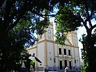
Nossa Senhora da Penha Cathedral
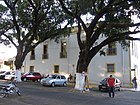
Historical Museum of Crato

Fossil Museum of the Centro de Pesquisas Paleontológicas da Bacia do Araripe

Former railway station

Seminario São José


cult
Crato is the seat of the Diocese of Crato . The patron saint of the city is based on a Marian veneration, which is named after the Portuguese city Penha de França and found its way into ritual and festive life as Nossa Senhora da Penha de França .
education
Crato is the seat of the Universidade Regional do Cariri (URCA), founded in 1986, with locations in other cities. The university maintains the Museu de Paleontologia da Universidade Regional do Cariridas in Santana do Cariri , also known as the Museu de Paleontologia Plácido Cidade Nuvens (Paleontology and Fossil Museum ).
traffic
The city can be reached from Fortaleza on the BR-122 federal road. Within Ceará it is connected to the Metrô do Cariri , which opened on December 1, 2009, but Crato's public transport system is considered to be inadequate.
The nearest airport is Juazeiro do Norte Airport in the neighboring city, south of the town of Crato there is a runway.
sons and daughters of the town
- José Martiniano Pereira de Alencar (1794–1860), priest, journalist and politician
- Joaquim Ferreira de Melo (1873–1940), Roman Catholic bishop
- Marcos Ceará (* 1980), football player
literature
- Prefeitura do Crato: Mapa Turístico. (Brochure, Portuguese).
- Raimundo Batista Aragão: História do Ceará. Imprensa Oficial do Ceará, Fortaleza 1985.
Web links
- Official Crato Portal (Portuguese)
Individual evidence
- ↑ a b c Crato - Panorama. In: cidades.ibge.gov.br. IBGE , accessed August 21, 2019 (Brazilian Portuguese).
- ↑ Climatic data for Crato , accessed on August 21, 2019.
- ^ Antonio Correia Lima: Historia de Crato. In: blogspot.com. October 21, 2011, accessed August 22, 2019 (Brazilian Portuguese).
- ^ Ceará State: Municípios do Ceará. In: blogspot.com. October 10, 2011, accessed August 22, 2019 (Brazilian Portuguese).
- ^ Brazilian Digital Library: O Araripe - 1855 a 1864. In: memoria.bn.br. Retrieved August 24, 2019 .
- ^ Zé Ailton 11 (Prefeito). In: todapolitica.com. Eleições 2016, accessed August 21, 2019 (Brazilian Portuguese).
- ^ Eleições no Crato / CE. In: todapolitica.com. Eleições 2016, accessed August 22, 2019 (Brazilian Portuguese).
- ↑ Crato. Ceará - CE. (PDF; 15 kB).
- ^ A b Atlas do Desenvolvimento Humano no Brasil: Crato (CE). Retrieved August 21, 2019 (Brazilian Portuguese).
- ↑ Embrapa : Urbanização das cidades brasileiras. In: webcitation.org. Retrieved August 21, 2019 (archived 2011).
- ↑ IBGE : Sistema IBGE de Recuperação Automática - SIDRA: Tabela 2093. Accessed on August 21, 2019 (Portuguese, database query, search terms Crato (CE) and Cor ou raça).
- ↑ Expocrato começa domingo com grandes atrações nacionais. In: com.br. O Estado CE, July 6, 2012, accessed August 21, 2019 (Brazilian Portuguese).
- ↑ Eduardo S. Guimarães et al. a .: Matrix of Priorities for the Management of Visitation Impacts on the Geosites of Araripe UNESCO Global Geopark (NE Brazil) . In: Geosciences . tape 8 , no. 6 , June 1, 2018, p. 199–220 , doi : 10.3390 / geosciences8060199 (English, mdpi.com [accessed on August 21, 2019]).
- ↑ Rubens Gondim Lossio: Nossa Senhora da Penha de França, Padroeira do Crato. In: Itaytera, órgão do Instituto Cultural do Cariri, Crato (CE). Volume VI, 1961, No. VI.
- ^ Universidade Regional do Cariri. In: urca.br. Retrieved August 22, 2019 (Brazilian Portuguese).
- ↑ Sobre. In: museudepaleontologiaplacidocidadenuvens.com. Museu de Paleontologia Plácido Cidade Nuvens, accessed on August 22, 2019 .
