Itapipoca
| Itapipoca | ||
|---|---|---|
|
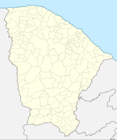
Coordinates: 3 ° 30 ′ S , 39 ° 35 ′ W Itapipoca on the map of Ceará
|
||
| Basic data | ||
| Country |
|
|
| State |
|
|
| City foundation | February 3, 1823 | |
| Residents | 128,135 (2018 estimate) | |
| City insignia | ||
| Detailed data | ||
| surface | 1613,913 km² | |
| Population density | 79.4 inhabitants / km 2 | |
| height | 109 m | |
| Time zone | UTC −3 | |
| Website | ||
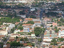
| Partial view of the center | ||
| Praça da Catedral Diocesana | ||
Itapipoca , officially Município de Itapipoca , is a city in the Brazilian state of Ceará with about 128,000 inhabitants.
Web links
Commons : Itapipoca - collection of images, videos and audio files
- City Prefecture website , Prefeitura Municipal (Brazilian Portuguese)
- City Council website , Câmara Municipal (Brazilian Portuguese)
- IBGE : Itapipoca - Panorama. In: cidades.ibge.gov.br. Retrieved November 11, 2018 (Brazilian Portuguese). Updated statistics.
Individual evidence
- ^ Brazilian Institute of Geography and Statistics . 2018. Retrieved March 6, 2019: "2018 Estimates of Population"


