Marvão
| Marvão | ||||||
|---|---|---|---|---|---|---|
|
||||||
| Basic data | ||||||
| Region : | Alentejo | |||||
| Sub-region : | Alto Alentejo | |||||
| District : | Portalegre | |||||
| Concelho : | Marvão | |||||
| Coordinates : | 39 ° 24 ′ N , 7 ° 22 ′ W | |||||
| Residents: | 3512 (as of June 30, 2011) | |||||
| Surface: | 154.9 km² (as of January 1, 2010) | |||||
| Population density : | 23 inhabitants per km² | |||||
| Marvão district | ||||||
|
||||||
| Residents: | 3512 (as of June 30, 2011) | |||||
| Surface: | 154.9 km² (as of January 1, 2010) | |||||
| Population density : | 23 inhabitants per km² | |||||
| Number of municipalities : | 4th | |||||
| administration | ||||||
| Administration address: | Câmara Municipal Largo de Santa Maria 7330-101 Marvão |
|||||
| President of the Câmara Municipal: | Victor Manuel Martins Frutuoso ( PSD / PPD ) | |||||
| Website: | www.cm-marvao.pt | |||||
Marvão is a small town ( Vila ) and a district ( concelho ) located on the Spanish border in Portugal with 3512 inhabitants (as of June 30, 2011). He belongs to the Portalegre district .
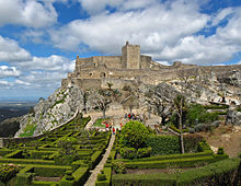
Located on a 800–860 m high rock plateau, the city offers a beautiful view of the surrounding Serra de São Mamede . Thanks to its strategic location on the border with Spain, the place can look back on an eventful history. In connection with the constant threats and conquests over the centuries, the city's extensive fortifications were created. An application for recognition as a UNESCO World Heritage Site ran from 2000 to 2017, but will not be pursued any further.
history
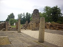
People have settled here since the Paleolithic and especially since the Neolithic . The Iron Age settlements and castros that emerged here later were taken over by the Romans from the 2nd century BC. Subjected to BC. Excavations of Roman estates prove the following intensive agricultural use of the area. Ammaia (now São Salvador da Aramenha ) was a civitas in what is now the district area. Ammaia was elevated to a Municipium until it was subdued by invading Germanic tribes from the 5th century onwards, and was probably flooded by a dam breach and largely abandoned.
From 711 the Moors conquered the Iberian Peninsula . They found the fortress remains of the city of Ammaia here, which they called Ammaia Castle. The Galician convert Ibn Marwan (Bem Marvão) built a new fortress here in 884 and laid out a village named after him, from which today's Marvão developed.
After a first conquest in 1166 by Portugal's first king, Afonso Henriques , only King Sancho II was able to finally take and repopulate the place in 1226.
In the course of the Restoration War (1640–1668), the fortifications were rebuilt, and after 1641 Marvão was mainly targeted by Spanish attacks in 1648. In connection with the War of the Spanish Succession , the place experienced a Franco-Spanish invasion in 1704. At the end of the Seven Years' War in 1762, the place was one of the few scenes of actual fighting in Portugal, when Spanish troops attacked the defense organized by Count Wilhelm zu Schaumburg-Lippe here . During the Napoleonic invasions , Marvão fell into French hands, only to be liberated in 1808 by Portuguese-Spanish insurgents.
During the Miguelistenkrieg in 1833 the place was taken with the consent of the population by liberal troops, who with the support of the residents and with supplies from Spain defied a siege by absolutist troops in 1834. In July 1847 Marvão was conquered one last time, by troops under the Spanish general Concha in connection with the civil war between liberal Setembrists and conservative Cartists .
Culture and sights
The local monuments include u. a. the castle and associated fortifications, historical fountains and bridges, the manor house Palácio Bourbon e Valle (also Palácio dos Barros Castelo-Branco Barba Mouzinho e Mattos ), and the pousada , which was furnished from 1954 . There are also a number of listed sacred buildings in Marvão, including the Convento de Nossa Senhora da Estrela . The Gothic building was started in 1448 and then expanded and redesigned several times.
The historic town center is also a listed building as a whole.
The three- story Casa da Cultura is housed in the old town hall . A permanent exhibition shows traditional handicrafts from the region, which are also produced and sold in an in-house workshop. In addition, temporary exhibitions and other events take place in other rooms. The city archive is also housed here.
The Museu Municipal , which opened in 1987 in the former church of Santa Maria , shows sacred , ethnographic and archaeological exhibits from the region.
Other museums include the two-story interactive local history museum in the old Moinho da Cova water mill , and the Roman archaeological site Ammaia in the municipality of São Salvador da Aramenha .
Hiking trails and nature trails are laid out in and around Marvão and the Serra de São Mamede . City tours, excursions on horses and other thematic tours are also offered.
The international film festival Festival Internacional de Cinema de Marvão has been taking place in Marvão and the surrounding villages since 2013 .
The Marvão International Music Festival has been taking place here from late July to early August since 2014 . It was initiated by the German conductor Christoph Poppen .
administration
circle
Marvão is the administrative seat of a district of the same name. In the north and east, the Marvão district borders on Spain , the neighboring districts are Portalegre in the south and Castelo de Vide in the north-west .
The district ( concelho ) Marvão consists of four communities ( freguesias ) , of which Santa Maria de Marvão includes the actual urban area of Marvão.
The communities are in detail:
| local community | Population (2011) |
Area km² |
Density of population / km² |
LAU code |
|---|---|---|---|---|
| Beirã | 498 | 44.76 | 11 | 121001 |
| Santa Maria de Marvão | 486 | 23.35 | 21st | 121002 |
| Santo António das Areias | 1.102 | 35.99 | 31 | 121003 |
| Sao Salvador da Aramenha | 1,426 | 50.80 | 28 | 121004 |
| Marvão district | 3,512 | 154.90 | 23 | 1210 |
Population development
| Population in the Marvão district (1801–2011) | |||||||||
|---|---|---|---|---|---|---|---|---|---|
| 1801 | 1849 | 1900 | 1930 | 1960 | 1981 | 1991 | 2001 | 2004 | 2011 |
| 4,048 | 3,780 | 5,994 | 7.116 | 7,478 | 5,418 | 4,419 | 4.029 | 3,739 | 3,512 |
Municipal holiday
- September 8th
Town twinning
-
 Brazil : Castelo do Piauí , State of Piauí
traffic
Until the cessation of passenger traffic on January 1, 2012, the place could be reached via the Ramal de Cáceres railway line .
Marvão is located on the national road N246, which joins the A23 motorway (here also European route 802 here) 50 km to the northwest , after having merged with the IP2 at Alpalhão after about 26 km .
Web links
Individual evidence
- ↑ a b c www.ine.pt - indicator resident population by place of residence and sex; Decennial in the database of the Instituto Nacional de Estatística
- ↑ a b Overview of code assignments from Freguesias on epp.eurostat.ec.europa.eu
- ↑ www.unesco.org , accessed July 27, 2013
- ^ Page of the city administration on the prehistory of the city , accessed on July 27, 2013
- ↑ www.verportugal.pt , accessed July 27, 2013
- ^ History page on the city administration website , accessed July 27, 2013
- ↑ www.monumentos.pt , accessed on July 27, 2013
- ↑ ditto
- ↑ ditto
- ↑ ditto
- ↑ www.verportugal.net , accessed on July 27, 2013
- ↑ ditto
- ↑ ditto
- ↑ Casa da Cultura page on the city administration's website ( Memento of the original from September 5, 2013 in the Internet Archive ) Info: The archive link has been inserted automatically and has not yet been checked. Please check the original and archive link according to the instructions and then remove this notice. , accessed July 27, 2013
- ^ Page of the Museu Municipal on the website of the city administration ( Memento of the original from September 5, 2013 in the Internet Archive ) Info: The archive link has been inserted automatically and has not yet been checked. Please check the original and archive link according to the instructions and then remove this notice. , accessed July 27, 2013
- ↑ The Moinho da Cova mill on the city administration's website ( Memento of the original from September 5, 2013 in the Internet Archive ) Info: The archive link has been inserted automatically and has not yet been checked. Please check the original and archive link according to the instructions and then remove this notice. , accessed July 27, 2013
- ↑ A Cidade Romana de Ammaia archaeological site Ammaia , accessed on April 1, 2016
- ↑ www.verportugal.net , accessed on July 27, 2013
- ↑ Routes on the website of the city administration ( memento of the original from September 5, 2013 in the Internet Archive ) Info: The archive link was inserted automatically and has not yet been checked. Please check the original and archive link according to the instructions and then remove this notice. , accessed July 27, 2013
- ↑ Information on the website of the city administration , accessed on July 27, 2013
- ↑ Article of September 12, 2014 in the Correio Alentejo newspaper on the second edition of the festival, accessed on October 11, 2014
- ↑ Official website of the festival . marvaomusic.com, accessed July 30, 2015
- ↑ Mozart with wind and clothespins . faz.de, accessed on July 30, 2015
- ↑ www.anmp.pt , accessed on July 27, 2013


