Baixo Alentejo
| Baixo Alentejo | |
|---|---|

|
|
| Basic data | |
| Country |
|
| region | Alentejo |
| Capital | Be yes |
| population | 126,718 (2013) |
| Population density | 14.8 inhabitants per km² |
| surface | 8,542.69 km² |
| Circles | 13 |
| Communities | 62 |
| ISO-3166-2 code | PT-184 |
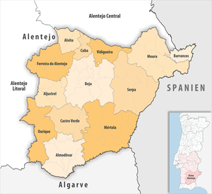
The Baixo Alentejo (German " Niederalentejo ") is a Portuguese sub-region . It is part of the Alentejo region and has the same districts as the Beja district , except for the Odemira district . In the north the Baixo Alentejo borders on the Alentejo Central , in the east on Spain , in the south on the Algarve and in the west on the Alentejo Litoral . The area of the sub-region is 8505 km². The Baixo Alentejo consists of 13 circles:
| circle | Number of municipalities |
Population (2011) |
Area km² |
Density of population / km² |
LAU code |
District |
|---|---|---|---|---|---|---|
| Aljustrel | 4th | 9,257 | 458.48 | 20th | 0201 | Be yes |
| Almodôvar | 6th | 7,449 | 777.88 | 10 | 0202 | Be yes |
| Alvito | 2 | 2,523 | 264.82 | 10 | 0203 | Be yes |
| Barrancos | 1 | 1,841 | 168.42 | 11 | 0204 | Be yes |
| Be yes | 12 | 35,854 | 1,146.43 | 31 | 0205 | Be yes |
| Castro Verde | 4th | 7,276 | 569.44 | 13 | 0206 | Be yes |
| Cuba | 4th | 4,878 | 172.09 | 28 | 0207 | Be yes |
| Ferreira do Alentejo | 4th | 8,255 | 648.24 | 13 | 0208 | Be yes |
| Mertola | 7th | 7,274 | 1,292.87 | 6th | 0209 | Be yes |
| Moura | 5 | 15,167 | 958.46 | 16 | 0210 | Be yes |
| Ourique | 4th | 5,389 | 663.32 | 8th | 0212 | Be yes |
| Serpa | 5 | 15,623 | 1,105.63 | 14th | 0213 | Be yes |
| Vidigueira | 4th | 5,932 | 316.61 | 19th | 0214 | Be yes |
| Baixo Alentejo | 62 | 126,718 | 8,542.69 | 15th | 184 | - |